METAR & TAF PAMC
Current METAR
Observed 06:53Z
PAMC 280653Z AUTO 22006KT 10SM -RA OVC060 11/09 A2993 RMK AO2 SLP139 P0000 T01110094 TSNO $
- Wind
- 220° @ 6 kt
- Visibility
- 10 SM
- Temp / Dew
- 11°C / 9°C
- Altimeter
- 29.93 inHg
- Clouds
- OVC
- Density alt
- -67 ft
- Ceiling
- 6,000 ft AGL
- Rules
- VFR
Airport info & contacts
Manager on record, flight service, ARTCC, attendance schedule and pattern altitude — published by the FAA and refreshed every 28 days.
Location
- From city
- 0 NM W
- VFR sectional
- MC GRATH
- ARTCC
- ZAN · ANCHORAGE
- NOTAM facility
- MCG (NOTAM-D)
Airport manager
- Name
- STEFFEN STRICK
- Phone
- 907-524-3241
- Address
- PO BOX 21, MCGRATH AK 99627
Flight service · Hours
- FSS MCG
- MCGRATH907-524-3611LD524-3611
- Attendance
- MAY-SEPT · MON-WED · 0700-1730
- OCT-APR · MON-FRI · 0800 - 1630
- MAY-SEPT · THURS · 0700-1500
Frequencies
Tap any row to copy the frequency to your clipboard.
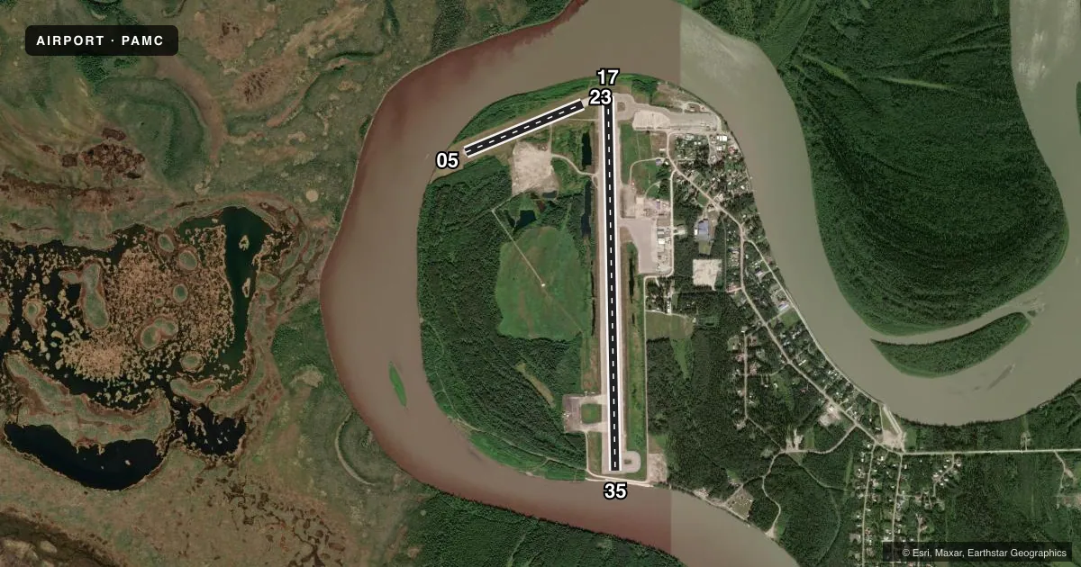
Runways & pattern
Full pagePattern entry · RWY 23
LEFT TRAFFIC| Runway | Heading (°M) | Length | Surface | Traffic |
|---|---|---|---|---|
| 17/35 | 167° / 347° | 5,936 ft | ASPH | Standard L |
| 05/23Favored | 56° / 236° | 2,000 ft | GRAVEL | Standard L |
Runway end performance
| End | TORA | TODA | ASDA | LDA | VGSI | Approach lights | Obstruction |
|---|---|---|---|---|---|---|---|
| 17 | 5,936' | 5,936' | 5,389' | 4,843' | VASI 4-box left(3°) | — | — |
| 35 | 5,936' | 5,936' | 5,390' | 4,843' | VASI 4-box left(3°) | — | 53', tree, 1305' from thr, 200' R of cntrln, slope 24 |
| 05 | — | — | — | — | — | — | 22', brush, 200' from thr, 110' R of cntrln, slope 9 |
Declared distances in feet. TORA = takeoff run available, TODA = takeoff distance, ASDA = accelerate-stop, LDA = landing distance.
Airport sketch
Runways drawn to scale from FAA survey coordinates, rendered over satellite imagery. Not for navigation.
Approaches & charts
ILS · 1
Services on the field
Fuel grades, oxygen, maintenance, ramp storage and lighting — as declared to the FAA by the airport operator.
Fuel & services
- Fuel
- 100LLA1+
- Airframe repair
- Minor
- Power plant repair
- Minor
- Other services
- CARGO
Ramp & ground
- Transient storage
- Tie-down
- Hangar
- Landing fee
- No fee published
- Customs
- Not available
- Lighting schedule
- SEE RMK
- Beacon schedule
- SS-SR
- Beacon
- White / Green (civil land)(WG)
- Wind indicator
- Lighted
- Segmented circle
- Yes
Fuel & FBOs
Cheapest 100LL and Jet A on the field and nearby. Always confirm with the FBO before taxi.
Airport notes
Surface conditions, obstructions, local procedures, lighting outages and other notes published with each FAA cycle.
General notes
- WATER FOWL ON & INVOF ARPT SPRING-FALL; MOOSE INVOF ARPT.
- FIRE ATTACK OPS DURG SUMMER.
- RWY COND UNMNT; RCMD VISUAL INSP BFR LNDG.
- CLSD TO ACR GTR THAN 30 PAX SEATS.
- PAEW ON RWY.
- APRON TSNT PRKG MKD BY GREEN CONES.
- WX CAMERA AVBL ON INTERNET AT HTTPS://WEATHERCAMS.FAA.GOV/.
- WX BLN FAC ON ARPT; SEE INSIDE BACK COVER FOR OPS DETAILS.
- MAINT SVC AVBL MAY-SEPT MON-THURS 0700L-1730L; OCT-APR MON-FRI 0800L-1700; AFT HR - AMGR.
- LOCK WHEELED TURNS NA.
- COLD TEMPERATURE AIRPORT. ALTITUDE CORRECTION REQUIRED AT OR BELOW -45C.
- ARPT SAND LRGR GRADATION THAN FAA RCMDD/SEE AC150/5200-30.
- FUEL SVC FEE AFT 1700 DAILY & ON SUNDAYS.
Lighting notes
- ACTVT REIL RWY 17 & 35; VASI RWY 17 & 35; MIRL RWY 05/23 & 17/35 - CTAF.
Runway surface & condition
- 17/35PCR VALUE: 450/F/C/W/T
Approach & departure obstructions
- 35ROAD 6 FT BLW 115 FT BYD RWY.
VFR map & nearby airports
VFR sectional. Tap any ICAO chip to open that airport.
Key facts · PAMC
Answer card- ICAO
- PAMC
- Name
- MC GRATH
- Location
- MC GRATH, ALASKA
- Elevation
- 342.7 ft MSL
- Traffic pattern altitude
- 1,342.7 ft MSL (1,000 AGL)
- Control tower
- Non-towered (use CTAF)
- Total runways
- 2
- Longest runway
- 17/35 · 5,936 ft
- Published ILS approaches
- 1
- Published frequencies
- 1
- Magnetic variation
- 12°
- Current flight rules
- VFR
- Current wind
- 220° at 6 kt
- Favored runway now
- RWY 23
Mc Grath Airport sits in Mc Grath, Alaska. Field elevation is 342.7 ft MSL. The airport has two runways. The longest is 5,936 ft asphalt runway 17/35. Runway 05/23 is 2,000 ft gravel. There is no control tower. Use CTAF 123.6 for traffic calls.
An ILS is published for runway 17. Pattern altitude is not published, so use standard traffic pattern judgment for the field. Verify the current pattern in the FAA Chart Supplement before you go. The airport is closed to aircraft greater than 30 passenger seats. That matters for planning if you are bringing a larger aircraft.
Northern Petroleum Services is on the field. It carries AVGAS 100LL, JET A, JET A PRIST and MOGAS. The airport also has a few operational points worth briefing before arrival. Runway condition is unmonitored. A visual check before landing is recommended. Pavement is reported rough. The airport sand is coarser than FAA guidance recommends. There is also a trail 7 feet below and 170 feet beyond runway 17. In cold weather, this is a cold temperature airport. Altitude correction is required at or below minus 45 degrees Celsius.