METAR & TAF PAFS
Current METAR
Observed 22:39Z
PAFS 272239Z AUTO 21007G20KT 10SM -RA BKN011 OVC016 13/12 A2983 RMK AO2 CIG 008V012 P0003 $
- Wind
- 210° @ 7G20 kt
- Visibility
- 10 SM
- Temp / Dew
- 13°C / 12°C
- Altimeter
- 29.83 inHg
- Clouds
- OVC
- Density alt
- 426 ft
- Ceiling
- 1,100 ft AGL
- Rules
- MVFR
Airport info & contacts
Manager on record, flight service, ARTCC, attendance schedule and pattern altitude — published by the FAA and refreshed every 28 days.
Location
- From city
- 1 NM NE
- VFR sectional
- MC GRATH
- ARTCC
- ZAN · ANCHORAGE
- NOTAM facility
- FSP (NOTAM-D)
Airport manager
- Name
- STEFFEN STRICK
- Phone
- 907-524-3241
- Address
- PO BOX 21, MCGRATH AK 99627
Flight service · Hours
- FSS ENA
- KENAI907-283-72111-866-864-1737
- Attendance
- Unattended
Frequencies
Tap any row to copy the frequency to your clipboard.
Runways & pattern
Full pagePattern entry · RWY 23
LEFT TRAFFICRunway end performance
| End | TORA | TODA | ASDA | LDA | VGSI | Approach lights | Obstruction |
|---|---|---|---|---|---|---|---|
| 05 | — | — | — | — | PAPI 4-box left(3.2°) | — | 10', brush, 0' from thr, 139' R of cntrln, slope 0 |
| 23 | — | — | — | — | PAPI 4-box left(3.2°) | — | 10', brush, 12' from thr, 92' R of cntrln, slope 1 |
Declared distances in feet. TORA = takeoff run available, TODA = takeoff distance, ASDA = accelerate-stop, LDA = landing distance.
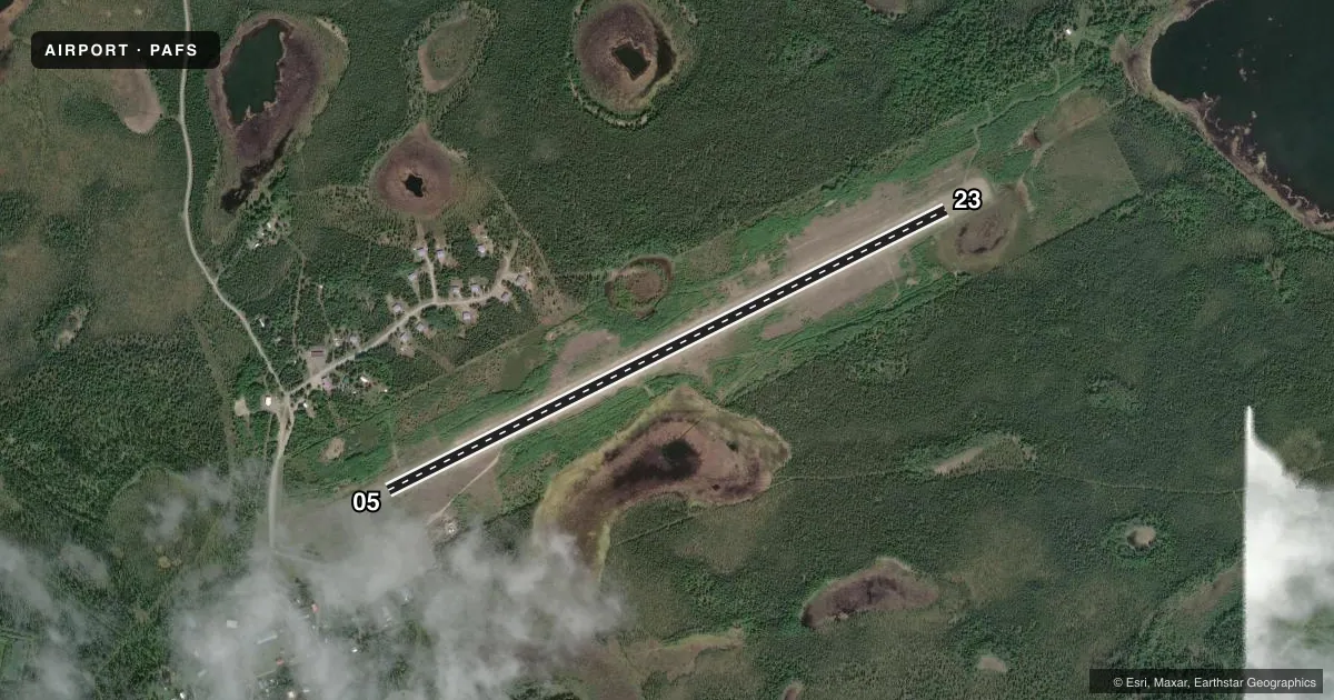
Airport sketch
Runways drawn to scale from FAA survey coordinates, rendered over satellite imagery. Not for navigation.
Approaches & charts
Services on the field
Fuel grades, oxygen, maintenance, ramp storage and lighting — as declared to the FAA by the airport operator.
Fuel & services
- Fuel
- Not available
Ramp & ground
- Transient storage
- Not published
- Landing fee
- No fee published
- Customs
- Not available
- Lighting schedule
- SEE RMK
- Beacon schedule
- SEE RMK
- Beacon
- White / Green (civil land)(WG)
- Wind indicator
- Lighted
- Segmented circle
- Yes
Fuel & FBOs
Cheapest 100LL and Jet A on the field and nearby. Always confirm with the FBO before taxi.
Airport notes
Surface conditions, obstructions, local procedures, lighting outages and other notes published with each FAA cycle.
General notes
- RWY COND UNMNT; RCMD VISUAL INSP BFR USE.
- WX CAMERA AVBL ON INTERNET AT HTTPS://WEATHERCAMS.FAA.GOV.
Lighting notes
- ACVT ROTG BCN - CTAF.
- ACTVT REIL RWY 05 & 23; PAPI RWY 05 & 23; MIRL RWY 05/23 - CTAF.
Runway surface & condition
- 05/23MULT LGTS BROKEN ENTIRE LEN. BRUSH & GRASS OBSC LGTS.
Other notes
- BRUSH INSIDE OF SEGMENTED CRC.
VFR map & nearby airports
VFR sectional. Tap any ICAO chip to open that airport.
Key facts · PAFS
Answer card- ICAO
- PAFS
- Name
- NIKOLAI
- Location
- NIKOLAI, ALASKA
- Elevation
- 447.3 ft MSL
- Traffic pattern altitude
- 1,447.3 ft MSL (1,000 AGL)
- Control tower
- Non-towered (use CTAF)
- Total runways
- 1
- Longest runway
- 05/23 · 4,001 ft
- Published ILS approaches
- 0
- Published frequencies
- 1
- Magnetic variation
- 14°
- Current flight rules
- MVFR
- Current wind
- 210° at 7 kt
- Favored runway now
- RWY 23
PAFS is the airport at Nikolai, Alaska. The field sits at 447.3 ft MSL. It has one runway, 05/23, which is 4,001 ft long and gravel. There is no control tower. CTAF is 122.8.
No ILS approaches are published here. Pattern altitude is not published, so use the standard 1,000 ft AGL for light piston operations unless the current FAA Chart Supplement says otherwise. The runway headings are magnetic. Runway 05/23 has medium intensity lighting controlled by CTAF. The runway end identifier lights and precision approach path indicators are also listed for both ends. Published remarks say runway condition is unmonitored, so a visual inspection before use is a good idea. The FAA notes broken lights along the runway and brush and grass that can hide them. Brush is also inside the segmented circle.
There are no on-field FBOs listed. Check with the airport operator or the FBO directly by phone before arrival if you need current services. This is a remote Alaska field, so plan for a basic self-brief. Use the current FAA Chart Supplement for any updated runway condition, lighting, or local operating notes before you go.