METAR & TAF PPCT
PPCT does not publish a METAR.
Showing the nearest reporting station: PAMC (MC GRATH) · 11.8 NM away. Conditions at PPCT may differ.
METAR · PAMC
Observed 04:53Z
PAMC 280453Z AUTO VRB06KT 10SM -RA BKN042 OVC055 12/11 A2991 RMK AO2 SLP130 P0001 T01170106 TSNO $
- Wind
- VAR @ 6 kt
- Visibility
- 10 SM
- Temp / Dew
- 12°C / 11°C
- Altimeter
- 29.91 inHg
- Clouds
- OVC
- Density alt
- 177 ft
- Ceiling
- 4,200 ft AGL
- Rules
- VFR
Airport info & contacts
Manager on record, flight service, ARTCC, attendance schedule and pattern altitude — published by the FAA and refreshed every 28 days.
Location
- From city
- 1 NM E
- VFR sectional
- MC GRATH
- ARTCC
- ZAN · ANCHORAGE
- NOTAM facility
- ENA (NOTAM-D)
Airport manager
- Name
- STEFFEN STRICK
- Phone
- 907-524-3241
- Address
- PO BOX 21, MC GRATH AK 99627
Flight service · Hours
- FSS ENA
- KENAI907-283-72111-866-864-1737
- Attendance
- Unattended
Frequencies
Tap any row to copy the frequency to your clipboard.
Runways & pattern
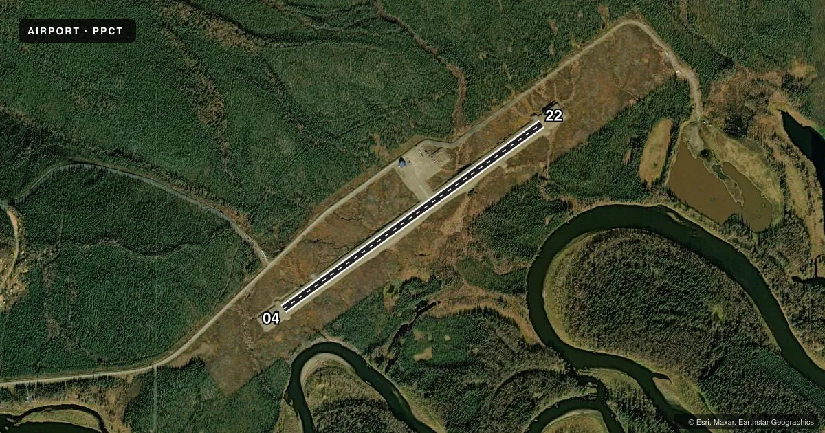
Full pagePattern entry · RWY 04
LEFT TRAFFICAirport sketch
Runways drawn to scale from FAA survey coordinates, rendered over satellite imagery. Not for navigation.
Approaches & charts
Services on the field
Fuel grades, oxygen, maintenance, ramp storage and lighting — as declared to the FAA by the airport operator.
Fuel & services
- Fuel
- Not available
- Oxygen (bottled)
- Not available
- Oxygen (bulk)
- Not available
- Airframe repair
- Not available
- Power plant repair
- Not available
Ramp & ground
- Transient storage
- Not published
- Landing fee
- No fee published
- Customs
- Not available
- Lighting schedule
- SEE RMK
- Beacon schedule
- SEE RMK
- Beacon
- White / Green (civil land)(WG)
- Wind indicator
- Lighted
- Segmented circle
- Yes
Fuel & FBOs
Cheapest 100LL and Jet A on the field and nearby. Always confirm with the FBO before taxi.
Airport notes
Surface conditions, obstructions, local procedures, lighting outages and other notes published with each FAA cycle.
General notes
- RWY CONDITION NOT MONITORED; RECOMMEND VISUAL INSPECTION BEFORE USING.
- WX CAMERA AVBL ON INTERNET AT HTTPS://WEATHERCAMS.FAA.GOV.
Lighting notes
- ACTVT ROTG BCN - CTAF.
- ACTVT MIRL RY 04/22 - CTAF.
Approach & departure obstructions
- 04RY 04/22 NSTD MKGS: RY MKD WITH REFLECTIVE CONES AND MARKERS.
Other notes
- ESTABD PRIOR TO 1959.
- 04/22RWY 04/22 MULTIPLE LATERAL CRACKS FULL LENGTH AND WIDTH OF RWY. UNEVEN SURFACE, DIPS, HEAVES AND HUMPS FULL LENGTH AND WIDTH OF RWY.
VFR map & nearby airports
VFR sectional. Tap any ICAO chip to open that airport.
Key facts · PPCT
Answer card- ICAO
- PPCT
- Name
- TAKOTNA
- Location
- TAKOTNA, ALASKA
- Elevation
- 423.1 ft MSL
- Traffic pattern altitude
- 1,423.1 ft MSL (1,000 AGL)
- Control tower
- Non-towered (use CTAF)
- Total runways
- 1
- Longest runway
- 04/22 · 3,300 ft
- Published ILS approaches
- 0
- Published frequencies
- 1
- Magnetic variation
- 17°
- Current flight rules
- VFR
- Current wind
- 000° at 6 kt
- Favored runway now
- RWY 04
Takotna Airport (PPCT) sits in Takotna, Alaska. Field elevation is 423.1 ft MSL. The airport has one runway. Runway 04/22 is 3,300 ft long and gravel. There is no control tower. CTAF is 122.9. No ILS approaches are published.
Pattern altitude is not published. Use the standard 1,000 ft AGL pattern for light piston traffic unless the current Chart Supplement says otherwise. The runway headings are magnetic. Runway 04/22 is marked with reflective cones and markers. Medium intensity runway lights and the rotating beacon are both activated by CTAF.
The published remarks matter here. The runway has multiple cracks across the full length and width. It is also uneven, with dips, heaves and humps. Runway condition is not monitored. Plan on a careful visual inspection before you commit to landing. The airport was established before 1959. There are no on-field FBOs listed, so verify services with the airport operator or call the field directly before arrival. For a first-time pilot, this is a gravel strip with a rough surface. Treat it like a short-field, condition-dependent arrival. Keep an eye on density altitude, wind and braking action.