METAR & TAF PANU
Current METAR
Observed 05:56Z
PANU 280556Z AUTO 23004KT 10SM -RA FEW002 BKN080 OVC095 14/13 A2982 RMK AO2 RAB32 SLP008 P0001 60005 T01390133 10206 20133 50004
- Wind
- 230° @ 4 kt
- Visibility
- 10 SM
- Temp / Dew
- 14°C / 13°C
- Altimeter
- 29.82 inHg
- Clouds
- OVC
- Density alt
- 507 ft
- Ceiling
- 8,000 ft AGL
- Rules
- VFR
Airport info & contacts
Manager on record, flight service, ARTCC, attendance schedule and pattern altitude — published by the FAA and refreshed every 28 days.
Location
- From city
- 1 NM NE
- VFR sectional
- NOME
- ARTCC
- ZAN · ANCHORAGE
- NOTAM facility
- FAI (NOTAM-D)
Airport manager
- Name
- JASON LUDINGTON
- Phone
- (907) 451-5280
- Address
- 2301 PEGER ROAD, FAIRBANKS AK 99709
Flight service · Hours
- FSS FAI
- FAIRBANKS907-474-07881-866-248-6516
- Attendance
- Unattended
Frequencies
Tap any row to copy the frequency to your clipboard.
Runways & pattern
Full pagePattern entry · RWY 21
LEFT TRAFFICRunway end performance
| End | TORA | TODA | ASDA | LDA | VGSI | Approach lights | Obstruction |
|---|---|---|---|---|---|---|---|
| 03 | — | — | — | — | — | — | 6', brush, 0' from thr, 95' R of cntrln, slope 0 |
| 21 | — | — | — | — | — | — | 6', brush, 0' from thr, 210' R of cntrln, slope 0 |
Declared distances in feet. TORA = takeoff run available, TODA = takeoff distance, ASDA = accelerate-stop, LDA = landing distance.
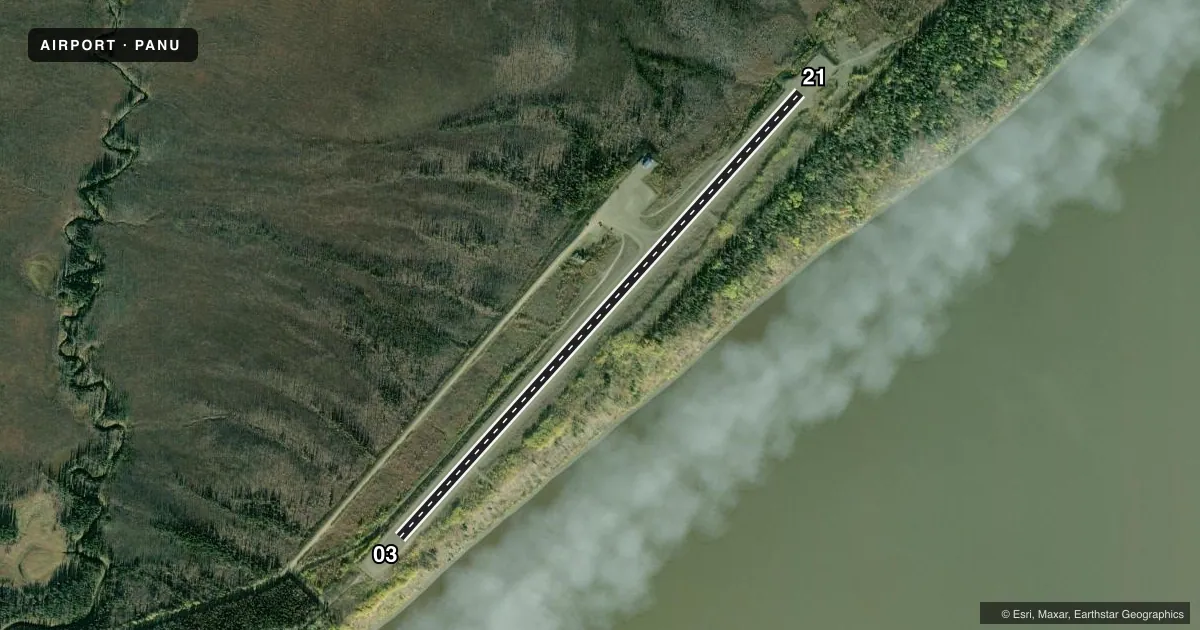
Airport sketch
Runways drawn to scale from FAA survey coordinates, rendered over satellite imagery. Not for navigation.
Approaches & charts
Services on the field
Fuel grades, oxygen, maintenance, ramp storage and lighting — as declared to the FAA by the airport operator.
Fuel & services
- Fuel
- Not available
- Oxygen (bottled)
- Not available
- Oxygen (bulk)
- Not available
- Airframe repair
- Not available
- Power plant repair
- Not available
Ramp & ground
- Transient storage
- Tie-down
- Landing fee
- No fee published
- Customs
- Not available
- Lighting schedule
- SEE RMK
- Beacon schedule
- SS-SR
- Beacon
- White / Green (civil land)(WG)
- Wind indicator
- Lighted
- Segmented circle
- Yes
Fuel & FBOs
Cheapest 100LL and Jet A on the field and nearby. Always confirm with the FBO before taxi.
Airport notes
Surface conditions, obstructions, local procedures, lighting outages and other notes published with each FAA cycle.
General notes
- RWY CONDITION NOT MONITORED; RECOMMEND VISUAL INSPECTION PRIOR TO LANDING.
- SNOW REMOVAL OPERATIONS DURING WINTER--MONITOR CTAF.
- WX CAMERA AVBL ON INTERNET AT HTTPS://WEATHERCAMS.FAA.GOV.
Lighting notes
- ACTVT MIRL RY 03/21 - CTAF.
Other notes
- ESTABD PRIOR TO 1959.
VFR map & nearby airports
VFR sectional. Tap any ICAO chip to open that airport.
Key facts · PANU
Answer card- ICAO
- PANU
- Name
- NULATO
- Location
- NULATO, ALASKA
- Elevation
- 405.9 ft MSL
- Traffic pattern altitude
- 1,405.9 ft MSL (1,000 AGL)
- Control tower
- Non-towered (use CTAF)
- Total runways
- 1
- Longest runway
- 03/21 · 4,011 ft
- Published ILS approaches
- 0
- Published frequencies
- 1
- Magnetic variation
- 13°
- Current flight rules
- VFR
- Current wind
- 230° at 4 kt
- Favored runway now
- RWY 21
Nulato Airport sits in Nulato, Alaska. The field elevation is 405.9 ft MSL. It has one runway. Runway 03/21 is 4,011 ft long and gravel. There is no control tower. CTAF is 122.9.
No ILS approaches are published here. Pattern altitude is not published, so use standard traffic pattern planning unless the current Chart Supplement says otherwise. The runway lights on 03/21 are medium intensity and are activated by CTAF. Winter snow removal happens here, so listen on CTAF for field updates. The runway condition is not monitored, so a visual check before landing is a good idea. A weather camera is available through the FAA weather camera system.
There are no on-field FBOs listed. Check with the airport operator or the FBO directly by phone before arrival if you need local support. This is a gravel strip in a remote Alaska setting. Plan for surface condition checks, seasonal snow and the usual backcountry-style margin for weather and performance. The airport has been established since before 1959, which tells you it has long local use but not modern towered-field services.