METAR & TAF PASK
Current METAR
Observed 07:56Z
PASK 280756Z AUTO 26012G18KT 10SM CLR 11/08 A2982 RMK AO2 SLP093 T01110078
- Wind
- 260° @ 12G18 kt
- Visibility
- 10 SM
- Temp / Dew
- 11°C / 8°C
- Altimeter
- 29.82 inHg
- Clouds
- CLR
- Density alt
- -335 ft
- Ceiling
- Unlimited
- Rules
- VFR
Airport info & contacts
Manager on record, flight service, ARTCC, attendance schedule and pattern altitude — published by the FAA and refreshed every 28 days.
Location
- From city
- 0 NM E
- VFR sectional
- NOME
- ARTCC
- ZAN · ANCHORAGE
- NOTAM facility
- WLK (NOTAM-D)
Airport manager
- Name
- ALVIN WERNEKE
- Phone
- 907-442-3147
- Address
- BOX 55, KOTZEBUE AK 99752
Flight service · Hours
- FSS OTZ
- KOTZEBUE907-442-33101-800-478-7460
- Attendance
- Unattended
Frequencies
Tap any row to copy the frequency to your clipboard.
Runways & pattern
Full pagePattern entry · RWY 27
LEFT TRAFFIC| Runway | Heading (°M) | Length | Surface | Traffic |
|---|---|---|---|---|
| 04/22 | 37° / 217° | 3,002 ft | GRAVEL | Standard L |
| 09/27Favored | 90° / 270° | 2,659 ft | GRAVEL | Standard L |
Runway end performance
| End | TORA | TODA | ASDA | LDA | VGSI | Approach lights | Obstruction |
|---|---|---|---|---|---|---|---|
| 04 | — | — | — | — | VASI 4-box left(3°) | — | 5', brush, 0' from thr, 70' R of cntrln, slope 0 |
| 22 | — | — | — | — | — | — | 6', brush, 0' from thr, 70' R of cntrln, slope 0 |
| 09 | — | — | — | — | — | — | 7', brush, 0' from thr, 65' R of cntrln, slope 0 |
| 27 | — | — | — | — | PAPI 4-box right(3°) | — | 5', brush, 0' from thr, 70' R of cntrln, slope 0 |
Declared distances in feet. TORA = takeoff run available, TODA = takeoff distance, ASDA = accelerate-stop, LDA = landing distance.
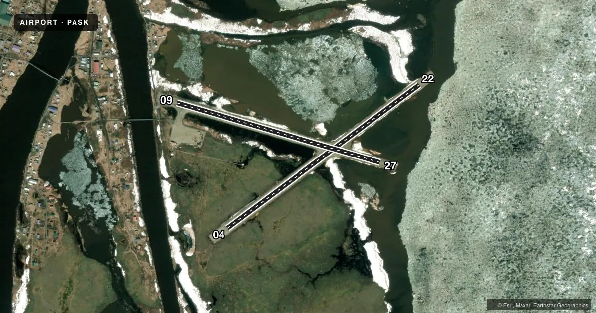
Airport sketch
Runways drawn to scale from FAA survey coordinates, rendered over satellite imagery. Not for navigation.
Approaches & charts
Services on the field
Fuel grades, oxygen, maintenance, ramp storage and lighting — as declared to the FAA by the airport operator.
Fuel & services
- Fuel
- Not available
Ramp & ground
- Transient storage
- Not published
- Landing fee
- No fee published
- Customs
- Not available
- Lighting schedule
- SEE RMK
- Beacon schedule
- SEE RMK
- Beacon
- White / Green (civil land)(WG)
- Wind indicator
- Lighted
- Segmented circle
- Yes
Fuel & FBOs
Cheapest 100LL and Jet A on the field and nearby. Always confirm with the FBO before taxi.
Airport notes
Surface conditions, obstructions, local procedures, lighting outages and other notes published with each FAA cycle.
General notes
- RWY COND UNMNT; RCMDD VISUAL INSP PRIOR TO USE.
- WX CAMERA AVBL ON INTERNET AT HTTPS://WEATHERCAMS.FAA.GOV
Lighting notes
- ACTVT ROTG BCN - CTAF.
- ACTVT VASI RWY 04; PAPI RWY 27; MIRL RWY 09/27 & 04/22 - CTAF.
Other notes
- THIS AIRPORT HAS BEEN SURVEYED BY THE NATIONAL GEODETIC SURVEY.
- NORTHWEST ARCTIC BOROUGH
VFR map & nearby airports
VFR sectional. Tap any ICAO chip to open that airport.
Key facts · PASK
Answer card- ICAO
- PASK
- Name
- SELAWIK
- Location
- SELAWIK, ALASKA
- Elevation
- 17.1 ft MSL
- Traffic pattern altitude
- 1,017.1 ft MSL (1,000 AGL)
- Control tower
- Non-towered (use CTAF)
- Total runways
- 2
- Longest runway
- 04/22 · 3,002 ft
- Published ILS approaches
- 0
- Published frequencies
- 1
- Magnetic variation
- 16°
- Current flight rules
- VFR
- Current wind
- 260° at 12 kt
- Favored runway now
- RWY 27
Selawik Airport sits in Selawik, Alaska. Field elevation is 17.1 ft MSL. It has two gravel runways. The longest is 3,002 ft on runway 04/22. There is no control tower. CTAF is 122.7. No ILS approaches are published here.
Pattern altitude is not published. Use the standard 1,000 ft AGL for light piston traffic unless the current Chart Supplement says otherwise. That puts the pattern at about 1,017 ft MSL based on the field elevation, but verify before you fly. Runway headings are magnetic. Runway 04/22 is 53°/233°. Runway 09/27 is 106°/286°.
The airport has a few items worth planning for. Runway condition is unmonitored, so a visual inspection before use is smart. Lighting is CTAF-activated. Runway 04 has a visual approach slope indicator. Runway 27 has a precision approach path indicator. Medium intensity runway lights are available for both runways. The rotating beacon is also CTAF-activated.
No on-field FBOs are listed. Check with the airport operator or the FBO directly by phone before arrival if you need services. Selawik is in the Northwest Arctic Borough. Weather camera coverage is available online, which can help with a quick look at local conditions before departure.