METAR & TAF PABL
Current METAR
Observed 07:56Z
PABL 280756Z AUTO 33008KT 10SM CLR 12/06 A2984 RMK AO2 SLP108 T01220056 401440061
- Wind
- 330° @ 8 kt
- Visibility
- 10 SM
- Temp / Dew
- 12°C / 6°C
- Altimeter
- 29.84 inHg
- Clouds
- CLR
- Density alt
- -225 ft
- Ceiling
- Unlimited
- Rules
- VFR
Airport info & contacts
Manager on record, flight service, ARTCC, attendance schedule and pattern altitude — published by the FAA and refreshed every 28 days.
Location
- From city
- 1 NM SW
- VFR sectional
- NOME
- ARTCC
- ZAN · ANCHORAGE
- NOTAM facility
- BVK (NOTAM-D)
Airport manager
- Name
- ALVIN WERNEKE
- Phone
- 907-442-3147
- Address
- PO BOX 55, KOTZEBUE AK 99752
Flight service · Hours
- FSS OTZ
- KOTZEBUE907-442-33101-800-478-7460
- Attendance
- Unattended
Frequencies
Tap any row to copy the frequency to your clipboard.
Runways & pattern
Full pagePattern entry · RWY 29
LEFT TRAFFICRunway end performance
| End | TORA | TODA | ASDA | LDA | VGSI | Approach lights | Obstruction |
|---|---|---|---|---|---|---|---|
| 11 | — | — | — | — | VASI 4-box right(3°) | — | 5', brush, 0' from thr, 95' R of cntrln, slope 0 |
| 29 | — | — | — | — | VASI 4-box left(3.5°) | — | 60', ant, 1545' from thr, 155' R of cntrln, slope 25 |
Declared distances in feet. TORA = takeoff run available, TODA = takeoff distance, ASDA = accelerate-stop, LDA = landing distance.
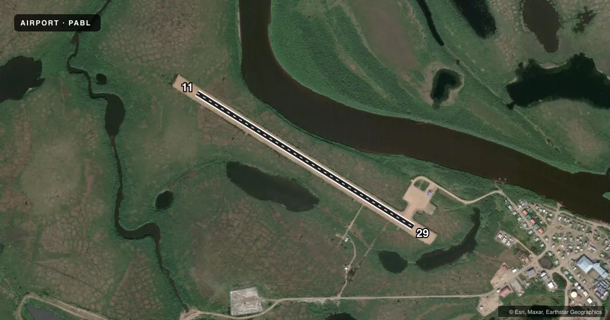
Airport sketch
Runways drawn to scale from FAA survey coordinates, rendered over satellite imagery. Not for navigation.
Approaches & charts
Services on the field
Fuel grades, oxygen, maintenance, ramp storage and lighting — as declared to the FAA by the airport operator.
Fuel & services
- Fuel
- Not available
Ramp & ground
- Transient storage
- Not published
- Lighting schedule
- SEE RMK
- Beacon schedule
- SS-SR
- Beacon
- White / Green (civil land)(WG)
- Wind indicator
- Lighted
- Segmented circle
- Yes
Fuel & FBOs
Cheapest 100LL and Jet A on the field and nearby. Always confirm with the FBO before taxi.
Airport notes
Surface conditions, obstructions, local procedures, lighting outages and other notes published with each FAA cycle.
General notes
- RWY COND UNMNT; RCMD VISUAL INSP BFR USE.
- WATERFOWL INVOF ARPT SPRING - FALL.
- WX CAMERA AVBL ON INTERNET AT HTTPS://WEATHERCAMS.FAA.GOV
Lighting notes
- ACTVT MIRL RWY 11/29 - CTAF. VASI RWY 11 & 29 OPR CONSLY.
Runway surface & condition
- 11/29TURB X WINDS SUMMER MONTHS.
Other notes
- NW ARCTIC BOROUGH.
VFR map & nearby airports
VFR sectional. Tap any ICAO chip to open that airport.
Key facts · PABL
Answer card- ICAO
- PABL
- Name
- BUCKLAND
- Location
- BUCKLAND, ALASKA
- Elevation
- 29 ft MSL
- Traffic pattern altitude
- 1,029 ft MSL (1,000 AGL)
- Control tower
- Non-towered (use CTAF)
- Total runways
- 1
- Longest runway
- 11/29 · 3,200 ft
- Published ILS approaches
- 0
- Published frequencies
- 1
- Magnetic variation
- 11°
- Current flight rules
- VFR
- Current wind
- 330° at 8 kt
- Favored runway now
- RWY 29
Buckland Airport (PABL) sits in Buckland, Alaska. The field elevation is 29 ft MSL. It has one runway, 11/29, which is 3,200 ft long and gravel. There is no control tower. CTAF is 122.9.
No ILS approaches are published here. The pattern altitude is not published, so use the current FAA Chart Supplement before you go. The runway lights on 11/29 are medium intensity lights that you activate by CTAF. The visual approach slope indicators on 11 and 29 operate continuously. The runway condition is unmonitored, so a visual inspection before use is a good idea.
This field is in the Northwest Arctic Borough. Waterfowl are reported in the area from spring through fall. Summer crosswinds can get turbulent on 11/29, so plan for a careful wind check before arrival. There are no on-field FBOs listed. Check with the airport operator or the FBO directly by phone for current services before you launch.