METAR & TAF PAOT
Current METAR
Observed 11:53Z
PAOT 281153Z AUTO 23004KT 10SM CLR 06/04 A2979 RMK AO2 SLP089 T00610039 10106 20061 50003 TSNO
- Wind
- 230° @ 4 kt
- Visibility
- 10 SM
- Temp / Dew
- 6°C / 4°C
- Altimeter
- 29.79 inHg
- Clouds
- CLR
- Density alt
- -900 ft
- Ceiling
- Unlimited
- Rules
- VFR
Airport info & contacts
Manager on record, flight service, ARTCC, attendance schedule and pattern altitude — published by the FAA and refreshed every 28 days.
Location
- From city
- 1 NM S
- VFR sectional
- NOME
- ARTCC
- ZAN · ANCHORAGE
- NOTAM facility
- OTZ (NOTAM-D)
Airport manager
- Name
- ANDREW GREENE
- Phone
- 907-442-3147
- Address
- BOX 55, KOTZEBUE AK 99752
Flight service · Hours
- FSS OTZ
- KOTZEBUE907-442-33101-800-478-7460
- Attendance
- WED-MON · 0700-1900
Frequencies
Tap any row to copy the frequency to your clipboard.
Runways & pattern
Full pagePattern entry · RWY 18
LEFT TRAFFIC| Runway | Heading (°M) | Length | Surface | Traffic |
|---|---|---|---|---|
| 09/27 | 91° / 271° | 6,300 ft | ASPH | Standard L |
| 18/36Favored | 183° / 3° | 3,876 ft | GRVL | Standard L |
Runway end performance
| End | TORA | TODA | ASDA | LDA | VGSI | Approach lights | Obstruction |
|---|---|---|---|---|---|---|---|
| 09 | 6,300' | 6,300' | 6,300' | 5,900' | PAPI 4-box right(3°) | — | 15', road, 30' from thr, slope 0 |
| 27 | 5,900' | 5,900' | 5,900' | 5,900' | PAPI 4-box left(3.3°) | — | 38', hill, 800' from thr, 0' R of cntrln, slope 15 |
| 18 | — | — | — | — | — | — | 15', road, 400' from thr, 0' R of cntrln, slope 26 |
Declared distances in feet. TORA = takeoff run available, TODA = takeoff distance, ASDA = accelerate-stop, LDA = landing distance.
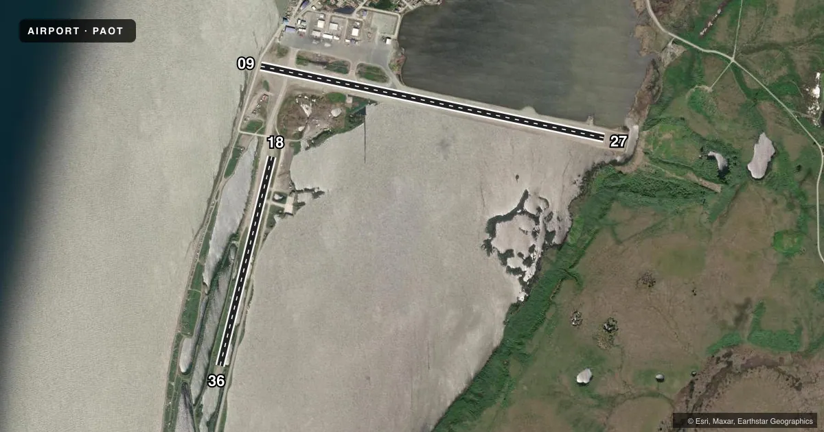
Airport sketch
Runways drawn to scale from FAA survey coordinates, rendered over satellite imagery. Not for navigation.
Approaches & charts
ILS · 1
Services on the field
Fuel grades, oxygen, maintenance, ramp storage and lighting — as declared to the FAA by the airport operator.
Fuel & services
- Fuel
- 100A
- Airframe repair
- Minor
- Power plant repair
- Minor
- Other services
- CARGO
Ramp & ground
- Transient storage
- Hangar
- Landing fee
- No fee published
- Customs
- Not available
- Lighting schedule
- SEE RMK
- Beacon schedule
- SS-SR
- Beacon
- White / Green (civil land)(WG)
- Wind indicator
- Lighted
- Segmented circle
- Yes
Fuel & FBOs
Cheapest 100LL and Jet A on the field and nearby. Always confirm with the FBO before taxi.
Airport notes
Surface conditions, obstructions, local procedures, lighting outages and other notes published with each FAA cycle.
General notes
- ARPT SVCS AVBL 0700-2000; AFT HR - AMGR.
- PRKG AREA UNLGTD. TSNT PRKG - FLT SVC.
- TWYS & RAMPS HAVE NMRS DIPS & ROUGH SFCS.
- SAND LRGR GRADATION THAN FAA RCMDD/SEE AC150/5200-30.
- NMRS 330 FT WIND TURBINE TWRS 3.5 MI SE.
- WX CAMERA AVBL ON INTERNET AT HTTPS://WEATHERCAMS.FAA.GOV
- BIRDS & WATERFOWL INVOF ARPT.
- TSA REGULATED: SEE 49 CFR 1542; ALL GATES & DOORS SECURED ALL TIMES; INFO - AMGR.
- IREG SFC TWY E 175 FT SW.
- FUEL SVC - 907-412-0775.
- RWY, TWY & RAMP EDGE LGTS EXTD 30 IN ABV GND.
Lighting notes
- ACTVT REIL RWY 09 & 27 - CTAF. HIRL RWY 09/27; MIRL RWY 18/36 ON 0700-2400; OTR TIME - CTAF. PAPI RWY 09 & 27 ON CONSLY.
Runway surface & condition
- 09/27PCR VALUE: 713/F/B/X/T
- 09/27SAFETY AREA NON STD. LOCKED WHEEL TURNS NA.
- 18/36ACR OPS MORE THAN 30 PAX SEATS NA. WINGSPAN GTR THAN 49 FT PPR - AMGR. UNCTLD VEHICLE ACES.
Approach & departure obstructions
- 09ROAD 430 FT FM THR; VEHICLE HGT LTD TO 13 FT.
- 09IREG SFC 1175 FT E OF THR.
Other notes
- CLSD TO ACR OPS MORE THAN 30 PAX SEATS EXC PPR IN WRITING - AMGR BOX 55 KOTZEBUE AK 99752.
VFR map & nearby airports
VFR sectional. Tap any ICAO chip to open that airport.
Key facts · PAOT
Answer card- ICAO
- PAOT
- Name
- RALPH WIEN MEML
- Location
- KOTZEBUE, ALASKA
- Elevation
- 15.4 ft MSL
- Traffic pattern altitude
- 1,015.4 ft MSL (1,000 AGL)
- Control tower
- Non-towered (use CTAF)
- Total runways
- 2
- Longest runway
- 09/27 · 6,300 ft
- Published ILS approaches
- 1
- Published frequencies
- 2
- Magnetic variation
- 11°
- Current flight rules
- VFR
- Current wind
- 230° at 4 kt
- Favored runway now
- RWY 18
Ralph Wien Memorial Airport sits in Kotzebue, Alaska. The field elevation is 15.4 ft MSL. It has two runways. The longest is 09/27 at 6,300 ft. There is no control tower, so expect non-towered procedures on CTAF 123.6 or UNICOM 122.8. The airport has one ILS approach on runway 09. Pattern altitude is not published. Use the standard 1,000 ft AGL for light piston traffic unless the current Chart Supplement says otherwise.
Crowley Aviation Fuels is on the field. It carries 100LL and Jet A. Bering Air is also on the field. It carries 100LL, Jet A and Jet A Prist. For fuel service calls, the published number is 907-412-0775. The airport remarks also note REIL activation on 09 and 27 via CTAF. High intensity lights serve 09/27. Medium intensity lights serve 18/36 from 0700 to 2400. Other times they are also activated via CTAF. That matters here because the airport sits in a coastal Alaska environment with birds and waterfowl in the area. The published remarks also call out a road 430 ft from the 09 threshold with a 13 ft vehicle height limit. Check the current Chart Supplement and coordinate with the airport operator if you are planning a larger aircraft or anything outside normal general aviation use.