METAR & TAF K29
K29 does not publish a METAR.
Showing the nearest reporting station: PAWM (WHITE MOUNTAIN) · 14.5 NM away. Conditions at K29 may differ.
METAR · PAWM
Observed 11:56Z
PAWM 281156Z AUTO VRB05KT 5SM -RA BR OVC007 08/08 A2994 RMK AO2 CIG 004V011 SLP141 P0000 60000 T00830078 10106 20083 51008 $
- Wind
- VAR @ 5 kt
- Visibility
- 5 SM
- Temp / Dew
- 8°C / 8°C
- Altimeter
- 29.94 inHg
- Clouds
- OVC
- Density alt
- -741 ft
- Ceiling
- 700 ft AGL
- Rules
- IFR
Airport info & contacts
Manager on record, flight service, ARTCC, attendance schedule and pattern altitude — published by the FAA and refreshed every 28 days.
Location
- From city
- 1 NM N
- VFR sectional
- NOME
- ARTCC
- ZAN · ANCHORAGE
- NOTAM facility
- OME (NOTAM-D)
Airport manager
- Name
- GEORGE KOST
- Phone
- 907-443-2500
- Address
- PO BOX 1048, NOME AK 99762
Flight service · Hours
- FSS OME
- NOMELC 443-22911-800-478-8400
- Attendance
- Unattended
Frequencies
Tap any row to copy the frequency to your clipboard.
Runways & pattern
Full pagePattern entry · RWY 28
LEFT TRAFFICRunway end performance
| End | TORA | TODA | ASDA | LDA | VGSI | Approach lights | Obstruction |
|---|---|---|---|---|---|---|---|
| 10 | — | — | — | — | — | — | 2', brush, 0' from thr, 40' R of cntrln, slope 0 |
| 28 | — | — | — | — | — | — | 3', brush, 0' from thr, 40' R of cntrln, slope 0 |
Declared distances in feet. TORA = takeoff run available, TODA = takeoff distance, ASDA = accelerate-stop, LDA = landing distance.
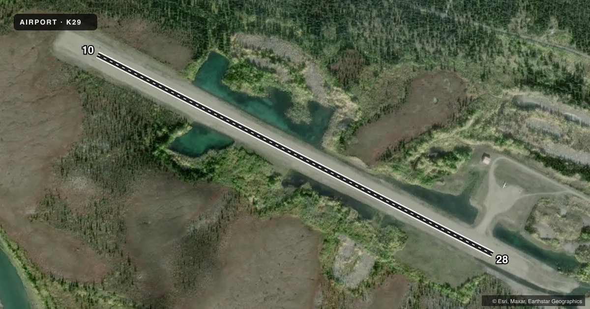
Airport sketch
Runways drawn to scale from FAA survey coordinates, rendered over satellite imagery. Not for navigation.
Approaches & charts
Services on the field
Fuel grades, oxygen, maintenance, ramp storage and lighting — as declared to the FAA by the airport operator.
Fuel & services
- Fuel
- Not available
Ramp & ground
- Transient storage
- Tie-down
- Wind indicator
- Yes
- Segmented circle
- Yes
Fuel & FBOs
Cheapest 100LL and Jet A on the field and nearby. Always confirm with the FBO before taxi.
Airport notes
Surface conditions, obstructions, local procedures, lighting outages and other notes published with each FAA cycle.
General notes
- RY CONDITION NOT MONITORED; RECOMMEND VISUAL INSPECTION PRIOR TO LANDING.
- RY NOT MAINTAINED DURING WINTER.
- THLD PANELS FADED TO WHITE
Approach & departure obstructions
- 10RY 10/28 MARKED WITH CONES AND THLD PANELS.
Other notes
- DETERMINATION PENDING.
- 10/28TALL GRASS ON RUNWAY AND RAMP
VFR map & nearby airports
VFR sectional. Tap any ICAO chip to open that airport.
Key facts · K29
Answer card- ICAO
- K29
- Name
- COUNCIL
- Location
- COUNCIL, ALASKA
- Elevation
- 100 ft MSL
- Traffic pattern altitude
- 1,100 ft MSL (1,000 AGL)
- Control tower
- Non-towered (use CTAF)
- Total runways
- 1
- Longest runway
- 10/28 · 3,000 ft
- Published ILS approaches
- 0
- Published frequencies
- 1
- Magnetic variation
- 18°
- Current flight rules
- IFR
- Current wind
- 000° at 5 kt
- Favored runway now
- RWY 28
Council Airport sits in Council, Alaska. Field elevation is 100 ft MSL. The airport has one runway. Runway 10/28 is 3,000 ft of turf, which is the longest runway on the field. There is no control tower. CTAF is 122.9. No ILS approaches are published here.
Pattern altitude is not published. Use 1,000 ft AGL as the standard light piston pattern unless local procedures or current chart data say otherwise. The published runway headings are magnetic. Runway 10/28 is marked with cones and threshold panels. The threshold panels are faded to white. Tall grass is reported on the runway and ramp. The runway is not maintained during winter. Runway condition is not monitored, so a visual inspection before landing makes sense here.
There are no on-field FBOs listed. Plan on self-sufficiency and verify current field conditions before departure. For a first-time arrival, the main issues are the turf surface, winter maintenance and the need to judge the runway yourself from the air. Check the current FAA Chart Supplement and contact the airport operator directly if you need current operational details before you go.