METAR & TAF Z47
Z47 does not publish a METAR.
Showing the nearest reporting station: PAOM (NOME) · 10.7 NM away. Conditions at Z47 may differ.
METAR · PAOM
Observed 06:53Z
PAOM 270653Z AUTO 19009KT 10SM FEW090 13/09 A2982
- Wind
- 190° @ 9 kt
- Visibility
- 10 SM
- Temp / Dew
- 13°C / 9°C
- Altimeter
- 29.82 inHg
- Clouds
- FEW
- Density alt
- 61 ft
- Ceiling
- Unlimited
- Rules
- VFR
Airport info & contacts
Manager on record, flight service, ARTCC, attendance schedule and pattern altitude — published by the FAA and refreshed every 28 days.
Location
- From city
- 0 NM W
- VFR sectional
- NOME
- ARTCC
- ZAN · ANCHORAGE
- NOTAM facility
- OME (NOTAM-D)
Airport manager
- Name
- RON ENGSTROM
- Phone
- 907-443-2586
- Address
- PO BOX 536, NOME AK 99762
Flight service · Hours
- FSS OME
- NOMELC 443-22911-800-478-8400
- Attendance
- Unattended
Frequencies
Tap any row to copy the frequency to your clipboard.
Runways & pattern
Full pagePattern entry · RWY 16
LEFT TRAFFICRunway end performance
| End | TORA | TODA | ASDA | LDA | VGSI | Approach lights | Obstruction |
|---|---|---|---|---|---|---|---|
| 16 | — | — | — | — | — | — | 6', brush, 0' from thr, 70' R of cntrln, slope 0 |
| 34 | — | — | — | — | — | — | 5', brush, 2' from thr, 29' R of cntrln, slope 0 |
Declared distances in feet. TORA = takeoff run available, TODA = takeoff distance, ASDA = accelerate-stop, LDA = landing distance.
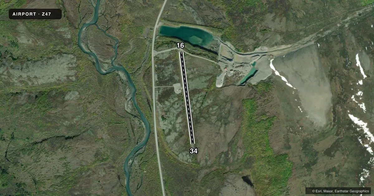
Airport sketch
Runways drawn to scale from FAA survey coordinates, rendered over satellite imagery. Not for navigation.
Approaches & charts
Services on the field
Fuel grades, oxygen, maintenance, ramp storage and lighting — as declared to the FAA by the airport operator.
Fuel & services
- Fuel
- Not available
- Oxygen (bottled)
- Not available
- Oxygen (bulk)
- Not available
- Airframe repair
- Not available
- Power plant repair
- Not available
Ramp & ground
- Transient storage
- Not published
- Landing fee
- No fee published
- Customs
- Not available
- Wind indicator
- Yes
- Segmented circle
- No
Fuel & FBOs
Cheapest 100LL and Jet A on the field and nearby. Always confirm with the FBO before taxi.
Airport notes
Surface conditions, obstructions, local procedures, lighting outages and other notes published with each FAA cycle.
General notes
- RY COND NOT MONITORED; RECOMMEND VISUAL INSPECTION PRIOR TO LANDING.
- RY SOFT DURING RAIN SEASON.
Approach & departure obstructions
- 16PVT ROAD 70 FT FRM RY 16 THLD.
Other notes
- 16/34TALL GRASS ON RWY
VFR map & nearby airports
VFR sectional. Tap any ICAO chip to open that airport.
Key facts · Z47
Answer card- ICAO
- Z47
- Name
- ENGSTROM FLD
- Location
- BASIN CREEK, ALASKA
- Elevation
- 143 ft MSL
- Traffic pattern altitude
- 1,143 ft MSL (1,000 AGL)
- Control tower
- Non-towered (use CTAF)
- Total runways
- 1
- Longest runway
- 16/34 · 2,000 ft
- Published ILS approaches
- 0
- Published frequencies
- 1
- Magnetic variation
- 17°
- Current flight rules
- VFR
- Current wind
- 190° at 9 kt
- Favored runway now
- RWY 16
Engstrom Fld is in Basin Creek, Alaska. The field elevation is 143 ft MSL. It has one runway, 16/34, which is 2,000 ft long with a gravel-dirt surface. The airport is not towered. CTAF is 122.9. No ILS approaches are published here.
Pattern altitude is not published. Use 1,000 ft AGL as the standard light-piston pattern unless local conditions or current guidance say otherwise. That puts the pattern at about 1,143 ft MSL based on the field elevation. The runway headings are 173° and 353° magnetic. Published remarks matter here. There is a private road about 70 ft from the runway 16 threshold. The runway can be soft during the rain season. Tall grass is also reported on the runway. Runway condition is not monitored, so a careful visual check before landing makes sense.
No on-field FBOs are listed. Plan fuel and services accordingly. For any current operational details, check the current FAA Chart Supplement or call the airport operator directly before you go. This is a small Alaska strip with a short unpaved runway, so surface condition and braking action deserve attention on every arrival.