METAR & TAF PAWM
Current METAR
Observed 13:34Z
PAWM 281334Z AUTO 24006KT 5SM -RA BR OVC005 08/07 A2994 RMK AO2 CIG 003V009 P0001 $
- Wind
- 240° @ 6 kt
- Visibility
- 5 SM
- Temp / Dew
- 8°C / 7°C
- Altimeter
- 29.94 inHg
- Clouds
- OVC
- Density alt
- -533 ft
- Ceiling
- 500 ft AGL
- Rules
- IFR
Airport info & contacts
Manager on record, flight service, ARTCC, attendance schedule and pattern altitude — published by the FAA and refreshed every 28 days.
Location
- From city
- 1 NM N
- VFR sectional
- NOME
- ARTCC
- ZAN · ANCHORAGE
- NOTAM facility
- WMO (NOTAM-D)
Airport manager
- Name
- GEORGE KOST
- Phone
- 907-443-2500
- Address
- PO BOX 1048, NOME AK 99762
Flight service · Hours
- FSS OME
- NOMELC 443-22911-800-478-8400
- Attendance
- Unattended
Frequencies
Tap any row to copy the frequency to your clipboard.
Runways & pattern
Full pagePattern entry · RWY 15
LEFT TRAFFICRunway end performance
| End | TORA | TODA | ASDA | LDA | VGSI | Approach lights | Obstruction |
|---|---|---|---|---|---|---|---|
| 15 | — | — | — | — | — | — | 3', brush, 0' from thr, 80' R of cntrln, slope 0 |
| 33 | — | — | — | — | — | — | 4', brush, 0' from thr, 125' R of cntrln, slope 0 |
Declared distances in feet. TORA = takeoff run available, TODA = takeoff distance, ASDA = accelerate-stop, LDA = landing distance.
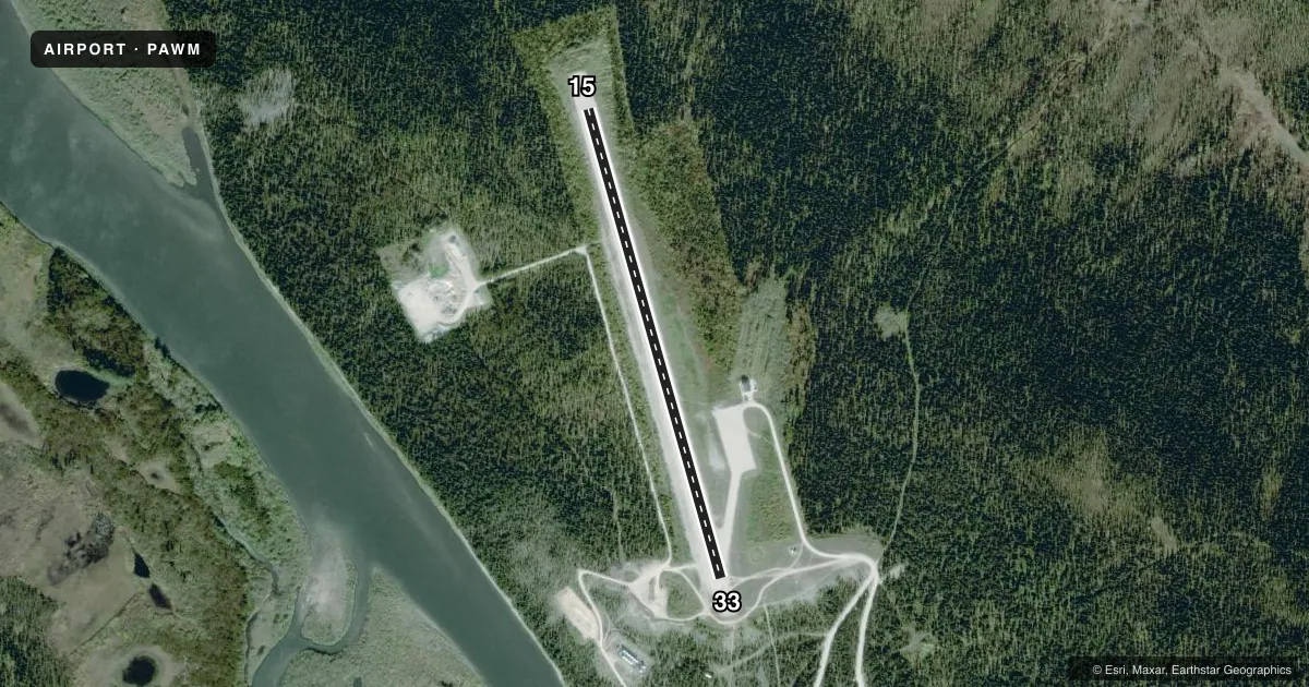
Airport sketch
Runways drawn to scale from FAA survey coordinates, rendered over satellite imagery. Not for navigation.
Approaches & charts
Services on the field
Fuel grades, oxygen, maintenance, ramp storage and lighting — as declared to the FAA by the airport operator.
Fuel & services
- Fuel
- Not available
Ramp & ground
- Transient storage
- Not published
- Landing fee
- No fee published
- Customs
- Not available
- Lighting schedule
- SEE RMK
- Beacon schedule
- SEE RMK
- Beacon
- White / Green (civil land)(WG)
- Wind indicator
- Lighted
- Segmented circle
- Yes
Fuel & FBOs
Cheapest 100LL and Jet A on the field and nearby. Always confirm with the FBO before taxi.
Airport notes
Surface conditions, obstructions, local procedures, lighting outages and other notes published with each FAA cycle.
General notes
- RWY COND UNMNT; RCMD VISUAL INSP BFR LNDG.
- WX CAMERA AVBL ON INTERNET AT HTTPS://WEATHERCAMS.FAA.GOV
Lighting notes
- H24.
- ACTVT MIRL RWY 15/33 - CTAF.
Runway surface & condition
- 15/33SLOPES DOWN AT RWY 33 THR NW TO SE. S END 45 FT HYR.
Approach & departure obstructions
- 33EXP TURB DURG APCH.
- 15CONES, LGTS & REFLECTIVE THR PANELS.
- 33CONES, LGTS & REFLECTIVE THR PANELS.
Other notes
- THIS AIRPORT HAS BEEN SURVEYED BY THE NATIONAL GEODETIC SURVEY.
- ESTABD PRIOR TO 1959.
- TALL BRUSH INVOF.
VFR map & nearby airports
VFR sectional. Tap any ICAO chip to open that airport.
Key facts · PAWM
Answer card- ICAO
- PAWM
- Name
- WHITE MOUNTAIN
- Location
- WHITE MOUNTAIN, ALASKA
- Elevation
- 267.4 ft MSL
- Traffic pattern altitude
- 1,267.4 ft MSL (1,000 AGL)
- Control tower
- Non-towered (use CTAF)
- Total runways
- 1
- Longest runway
- 15/33 · 3,000 ft
- Published ILS approaches
- 0
- Published frequencies
- 1
- Magnetic variation
- 12°
- Current flight rules
- IFR
- Current wind
- 240° at 6 kt
- Favored runway now
- RWY 15
White Mountain Airport sits in White Mountain, Alaska. Field elevation is 267.4 ft MSL. The airport has one runway. Runway 15/33 is 3,000 ft long and surfaced with gravel. There is no control tower. CTAF is 122.9. No ILS approaches are published here.
Pattern altitude is not published. Use 1,000 ft AGL for light piston traffic unless the current Chart Supplement says otherwise. The published remarks matter here. Expect turbulence on approach to runway 33. The runway slopes down toward the 33 threshold from northwest to southeast. The south end is 45 ft higher. Runway condition is unmonitored, so a visual check before landing is smart. Tall brush is also near the airport.
Runway lighting is pilot-controlled through CTAF. Medium intensity runway lights serve runway 15/33. Cones, lights and reflective threshold panels mark both runway ends. A beacon runs 24 hours a day. No on-field FBOs are listed, so plan on self-sufficiency and verify services with the airport operator before you go. This is an older field that was established before 1959. In this part of Alaska, weather and surface condition can change fast. Check the current Chart Supplement for any updated local notes before departure.