METAR & TAF PFEL
Current METAR
Observed 11:56Z
PFEL 281156Z AUTO 28008G15KT 10SM -RA OVC070 09/08 A2991 RMK AO2 SLP129 P0003 60005 70005 T00890078 10122 20089 51007 $
- Wind
- 280° @ 8G15 kt
- Visibility
- 10 SM
- Temp / Dew
- 9°C / 8°C
- Altimeter
- 29.91 inHg
- Clouds
- OVC
- Density alt
- -507 ft
- Ceiling
- 7,000 ft AGL
- Rules
- VFR
Airport info & contacts
Manager on record, flight service, ARTCC, attendance schedule and pattern altitude — published by the FAA and refreshed every 28 days.
Location
- From city
- 3 NM SW
- VFR sectional
- NOME
- ARTCC
- ZAN · ANCHORAGE
- NOTAM facility
- ELI (NOTAM-D)
Airport manager
- Name
- JOHN WILSON
- Phone
- (907) 625-1025
- Address
- PO BOX 192, UNALAKLEET AK 99684
Flight service · Hours
- FSS OME
- NOMELC 443-22911-800-478-8400
- Attendance
- Unattended
Frequencies
Tap any row to copy the frequency to your clipboard.
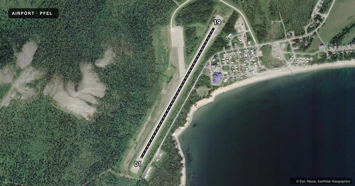
Runways & pattern
Full pagePattern entry · RWY 19
LEFT TRAFFICRunway end performance
| End | TORA | TODA | ASDA | LDA | VGSI | Approach lights | Obstruction |
|---|---|---|---|---|---|---|---|
| 01 | — | — | — | — | — | — | 12', tree, 20' from thr, 216' R of cntrln, slope 1 |
| 19 | — | — | — | — | — | — | 744', hill, 8700' from thr, slope 11 |
Declared distances in feet. TORA = takeoff run available, TODA = takeoff distance, ASDA = accelerate-stop, LDA = landing distance.
Airport sketch
Runways drawn to scale from FAA survey coordinates, rendered over satellite imagery. Not for navigation.
Approaches & charts
Services on the field
Fuel grades, oxygen, maintenance, ramp storage and lighting — as declared to the FAA by the airport operator.
Fuel & services
- Fuel
- Not available
- Oxygen (bottled)
- Not available
- Oxygen (bulk)
- Not available
- Airframe repair
- Not available
- Power plant repair
- Not available
Ramp & ground
- Transient storage
- Not published
- Landing fee
- No fee published
- Customs
- Not available
- Lighting schedule
- SEE RMK
- Beacon schedule
- SS-SR
- Beacon
- White / Green (civil land)(WG)
- Wind indicator
- Lighted
- Segmented circle
- Yes
Fuel & FBOs
Cheapest 100LL and Jet A on the field and nearby. Always confirm with the FBO before taxi.
Airport notes
Surface conditions, obstructions, local procedures, lighting outages and other notes published with each FAA cycle.
General notes
- RY CONDITION NOT MONITORED; RECOMMEND VISUAL INSPECTION PRIOR TO LANDING.
- +744 FT HILL 8700 FT FM RY END 500 FT R.
- WX CAMERA AVBL ON INTERNET AT HTTPS://WEATHERCAMS.FAA.GOV
- COLD TEMPERATURE AIRPORT. ALTITUDE CORRECTION REQUIRED AT OR BELOW -34C.
- SINKING AREA MIDFIELD WEST SIDE OF RWY 10'INSIDE LIGHTS 20' OUTSIDE.
Lighting notes
- ACTVT MIRL RY 01/19 - CTAF.
Runway surface & condition
- 01/19RY 19 SLOPES UPHILL 0.5% TO SOUTH END.
Approach & departure obstructions
- 01RWY 01/19 MARKED WITH LIGHTS AND PLASTIC MARKERS.
- 19RY 19, +744 FT HILL, DIST 8700 FT FM RY 19 END, 500 FT R.
Other notes
- THIS AIRPORT HAS BEEN SURVEYED BY THE NATIONAL GEODETIC SURVEY.
- ESTABD PRIOR TO 1959.
- SURVEYED
VFR map & nearby airports
VFR sectional. Tap any ICAO chip to open that airport.
Key facts · PFEL
Answer card- ICAO
- PFEL
- Name
- ELIM
- Location
- ELIM, ALASKA
- Elevation
- 161.5 ft MSL
- Traffic pattern altitude
- 1,161.5 ft MSL (1,000 AGL)
- Control tower
- Non-towered (use CTAF)
- Total runways
- 1
- Longest runway
- 01/19 · 3,401 ft
- Published ILS approaches
- 0
- Published frequencies
- 1
- Magnetic variation
- 9°
- Current flight rules
- VFR
- Current wind
- 280° at 8 kt
- Favored runway now
- RWY 19
PFEL is the airport for Elim, Alaska. The field sits at 161.5 ft MSL. It has one runway, 01/19, which is 3,401 ft long and surfaced gravel-dirt. There is no control tower. CTAF is 122.8. No ILS approaches are published here.
Pattern altitude is not published. Use the standard 1,000 ft AGL for light piston traffic unless the current Chart Supplement says otherwise. The runway is marked with lights and plastic markers. Medium intensity runway lights are controlled on CTAF. That helps for evening arrivals. You still need to confirm the lighting is working before you commit.
There are no on-field FBOs listed. Plan on self-sufficiency and verify services with the airport operator before you go. Published remarks say runway condition is not monitored, so a visual inspection before landing is a good idea. There is also a 744-foot hill 8,700 ft from the runway 19 end, 500 ft to the right. Runway 19 slopes uphill 0.5 percent to the south end. This is a cold temperature airport too. Altitude correction is required at or below minus 34 degrees Celsius. For a first-time arrival, treat this as a remote Alaska strip with limited published services, a gravel surface and terrain that deserves a close look on arrival and departure.