METAR & TAF PFSH
Current METAR
Observed 03:03Z
PFSH 280303Z AUTO 24016KT 10SM OVC008 13/11 A2989 RMK AO2 TSB02E03 $
- Wind
- 240° @ 16 kt
- Visibility
- 10 SM
- Temp / Dew
- 13°C / 11°C
- Altimeter
- 29.89 inHg
- Clouds
- OVC
- Density alt
- -173 ft
- Ceiling
- 800 ft AGL
- Rules
- IFR
Airport info & contacts
Manager on record, flight service, ARTCC, attendance schedule and pattern altitude — published by the FAA and refreshed every 28 days.
Location
- From city
- 1 NM NW
- VFR sectional
- NOME
- ARTCC
- ZAN · ANCHORAGE
- NOTAM facility
- 2C7
Airport manager
- Name
- JOHN WILSON
- Phone
- 907-625-1025
- Address
- BOX 192, UNALAKLEET AK 99684
Flight service · Hours
- FSS OME
- NOMELC 443-22911-800-478-8400
- Attendance
- Unattended
Frequencies
Tap any row to copy the frequency to your clipboard.
Runways & pattern
Full pagePattern entry · RWY 15
LEFT TRAFFICRunway end performance
| End | TORA | TODA | ASDA | LDA | VGSI | Approach lights | Obstruction |
|---|---|---|---|---|---|---|---|
| 33 | — | — | — | — | PAPI 4-box left(3°) | — | — |
Declared distances in feet. TORA = takeoff run available, TODA = takeoff distance, ASDA = accelerate-stop, LDA = landing distance.
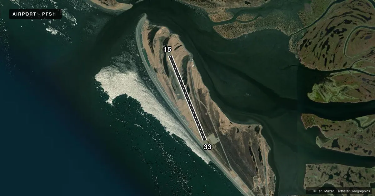
Airport sketch
Runways drawn to scale from FAA survey coordinates, rendered over satellite imagery. Not for navigation.
Approaches & charts
Services on the field
Fuel grades, oxygen, maintenance, ramp storage and lighting — as declared to the FAA by the airport operator.
Fuel & services
- Fuel
- Not available
Ramp & ground
- Transient storage
- Not published
- Lighting schedule
- SEE RMK
- Beacon schedule
- SS-SR
- Beacon
- White / Green (civil land)(WG)
- Wind indicator
- Lighted
- Segmented circle
- Yes
Fuel & FBOs
Cheapest 100LL and Jet A on the field and nearby. Always confirm with the FBO before taxi.
Airport notes
Surface conditions, obstructions, local procedures, lighting outages and other notes published with each FAA cycle.
General notes
- RWY COND UNMNT; RCMD VISUAL INSP BFR LNDG.
- CTN: CLSD ABNDD RWY UNMKD.
- WX CAMERA AVBL ON INTERNET AT HTTPS://WEATHERCAMS.FAA.GOV
Lighting notes
- ACTVT REIL RWY 33; PAPI RWY 33; MIRL RWY 15/33 - CTAF.
Approach & departure obstructions
- 15LGTS & CONES.
- 33LGTS & CONES.
Other notes
- THIS AIRPORT HAS BEEN SURVEYED BY THE NATIONAL GEODETIC SURVEY.
- MNT DALGT HRS BY LCL AIRLINE; RESPONSE N/A TO NON-SKED.
- 15/33PONDING & SLIPPERY WHEN WET.
VFR map & nearby airports
VFR sectional. Tap any ICAO chip to open that airport.
Key facts · PFSH
Answer card- ICAO
- PFSH
- Name
- SHAKTOOLIK
- Location
- SHAKTOOLIK, ALASKA
- Elevation
- 24.4 ft MSL
- Traffic pattern altitude
- 1,024.4 ft MSL (1,000 AGL)
- Control tower
- Non-towered (use CTAF)
- Total runways
- 1
- Longest runway
- 15/33 · 4,001 ft
- Published ILS approaches
- 0
- Published frequencies
- 2
- Magnetic variation
- 11°
- Current flight rules
- IFR
- Current wind
- 240° at 16 kt
- Favored runway now
- RWY 15
Shaktoolik Airport sits in Shaktoolik, Alaska. Field elevation is 24.4 ft MSL. The airport has one runway. Runway 15/33 is 4,001 ft long and gravel. There is no control tower. CTAF and UNICOM are both 122.8. No ILS approaches are published here.
Pattern altitude is not published. For light piston aircraft, use 1,000 ft AGL as the standard unless the current Chart Supplement or local procedures say otherwise. The field is low and coastal. Wet runway performance can change fast here. The published remarks say ponding and slippery conditions can occur when the runway is wet. Runway condition is also unmonitored. A visual inspection before landing is a good idea.
The published remarks also note lights and cones at both runway ends. Runway end identifier lights, a PAPI on runway 33 and medium intensity runway lights on 15/33 are activated via CTAF. The airport has been surveyed by the National Geodetic Survey. There is no on-field FBO listed. Check with the airport operator or the FBO directly by phone for current services before you go. The remarks also say the airport is maintained for daylight hours by a local airline. Non-scheduled aircraft may not get a response.