METAR & TAF PAMK
Current METAR
Observed 02:56Z
PAMK 270256Z AUTO 28009KT 10SM CLR 17/13 A2985 RMK AO2 RAB05E16 SLP107 P0000 60000 T01720128 50001
- Wind
- 280° @ 9 kt
- Visibility
- 10 SM
- Temp / Dew
- 17°C / 13°C
- Altimeter
- 29.85 inHg
- Clouds
- CLR
- Density alt
- 449 ft
- Ceiling
- Unlimited
- Rules
- VFR
Airport info & contacts
Manager on record, flight service, ARTCC, attendance schedule and pattern altitude — published by the FAA and refreshed every 28 days.
Location
- From city
- 2 NM W
- VFR sectional
- BETHEL
- ARTCC
- ZAN · ANCHORAGE
- NOTAM facility
- OME (NOTAM-D)
Airport manager
- Name
- JOHN WILSON
- Phone
- (907) 625-1025
- Address
- PO BOX 192, UNALAKLEET AK 99684
Flight service · Hours
- FSS OME
- NOMELC 443-22911-800-478-8400
- Attendance
- Unattended
Frequencies
Tap any row to copy the frequency to your clipboard.
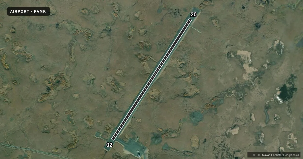
Runways & pattern
Full pagePattern entry · RWY 20
LEFT TRAFFICAirport sketch
Runways drawn to scale from FAA survey coordinates, rendered over satellite imagery. Not for navigation.
Approaches & charts
Services on the field
Fuel grades, oxygen, maintenance, ramp storage and lighting — as declared to the FAA by the airport operator.
Fuel & services
- Fuel
- Not available
Ramp & ground
- Transient storage
- Tie-down
- Landing fee
- No fee published
- Lighting schedule
- SEE RMK
- Beacon schedule
- SS-SR
- Beacon
- White / Green (civil land)(WG)
- Wind indicator
- Lighted
- Segmented circle
- Yes
Fuel & FBOs
Cheapest 100LL and Jet A on the field and nearby. Always confirm with the FBO before taxi.
Airport notes
Surface conditions, obstructions, local procedures, lighting outages and other notes published with each FAA cycle.
General notes
- COND UNMNT; RCMND VISUAL INSP PRIOR TO USE.
- WX CAMERA AVBL ON INTERNET AT HTTPS://WEATHERCAMS.FAA.GOV
- REINDEER HERDS INVOF ARPT JUN-OCT.
Lighting notes
- ACTVT MIRL RWY 02/20 - CTAF.
Runway surface & condition
- 02/20SLOPES UP 32 FT NE TO SW.
Other notes
- THIS AIRPORT HAS BEEN SURVEYED BY THE NATIONAL GEODETIC SURVEY.
VFR map & nearby airports
VFR sectional. Tap any ICAO chip to open that airport.
Key facts · PAMK
Answer card- ICAO
- PAMK
- Name
- ST MICHAEL
- Location
- ST MICHAEL, ALASKA
- Elevation
- 98.2 ft MSL
- Traffic pattern altitude
- 1,098.2 ft MSL (1,000 AGL)
- Control tower
- Non-towered (use CTAF)
- Total runways
- 1
- Longest runway
- 02/20 · 4,001 ft
- Published ILS approaches
- 0
- Published frequencies
- 2
- Magnetic variation
- 17°
- Current flight rules
- VFR
- Current wind
- 280° at 9 kt
- Favored runway now
- RWY 20
St Michael Airport is in St Michael, Alaska. Field elevation is 98.2 ft MSL. The airport has one runway. Runway 02/20 is 4,001 ft long and gravel. The runway headings are 33° and 213° magnetic. No control tower is published here. CTAF and UNICOM are both 122.8.
No ILS approaches are published for PAMK. Pattern altitude is not published, so use the standard 1,000 ft AGL for light piston traffic unless the current Chart Supplement says otherwise. The field has no on-field FBOs listed, so plan to verify services with the airport operator or by calling the field on CTAF before arrival.
A few published remarks matter here. The runway slopes up 32 ft from northeast to southwest. Condition is unmonitored, so a visual inspection before use is a good idea. Reindeer herds may be in the vicinity from June through October. Medium intensity runway lights on 02/20 are activated by using the common traffic advisory frequency. This is a small, non-towered Alaska field, so expect to manage your own spacing, surface check and weather picture before you commit.