METAR & TAF Z81
Z81 does not publish a METAR.
Showing the nearest reporting station: PAOM (NOME) · 26.2 NM away. Conditions at Z81 may differ.
METAR · PAOM
Observed 06:53Z
PAOM 270653Z AUTO 19009KT 10SM FEW090 13/09 A2982
- Wind
- 190° @ 9 kt
- Visibility
- 10 SM
- Temp / Dew
- 13°C / 9°C
- Altimeter
- 29.82 inHg
- Clouds
- FEW
- Density alt
- 515 ft
- Ceiling
- Unlimited
- Rules
- VFR
Airport info & contacts
Manager on record, flight service, ARTCC, attendance schedule and pattern altitude — published by the FAA and refreshed every 28 days.
Location
- From city
- 0 NM NW
- VFR sectional
- NOME
- ARTCC
- ZAN · ANCHORAGE
- NOTAM facility
- OME (NOTAM-D)
Airport manager
- Name
- GEORGE KOST
- Phone
- 907-443-3431
- Address
- PO BOX 1048, NOME AK 99762
Flight service · Hours
- FSS OME
- NOMELC 443-22911-800-478-8400
- Attendance
- Unattended
Frequencies
Tap any row to copy the frequency to your clipboard.
Runways & pattern
Full pagePattern entry · RWY 15
LEFT TRAFFICRunway end performance
| End | TORA | TODA | ASDA | LDA | VGSI | Approach lights | Obstruction |
|---|---|---|---|---|---|---|---|
| 15 | — | — | — | — | — | — | 2', brush, 0' from thr, 45' R of cntrln, slope 0 |
| 33 | — | — | — | — | — | — | 15', road, 0' from thr, 120' R of cntrln, slope 0 |
Declared distances in feet. TORA = takeoff run available, TODA = takeoff distance, ASDA = accelerate-stop, LDA = landing distance.
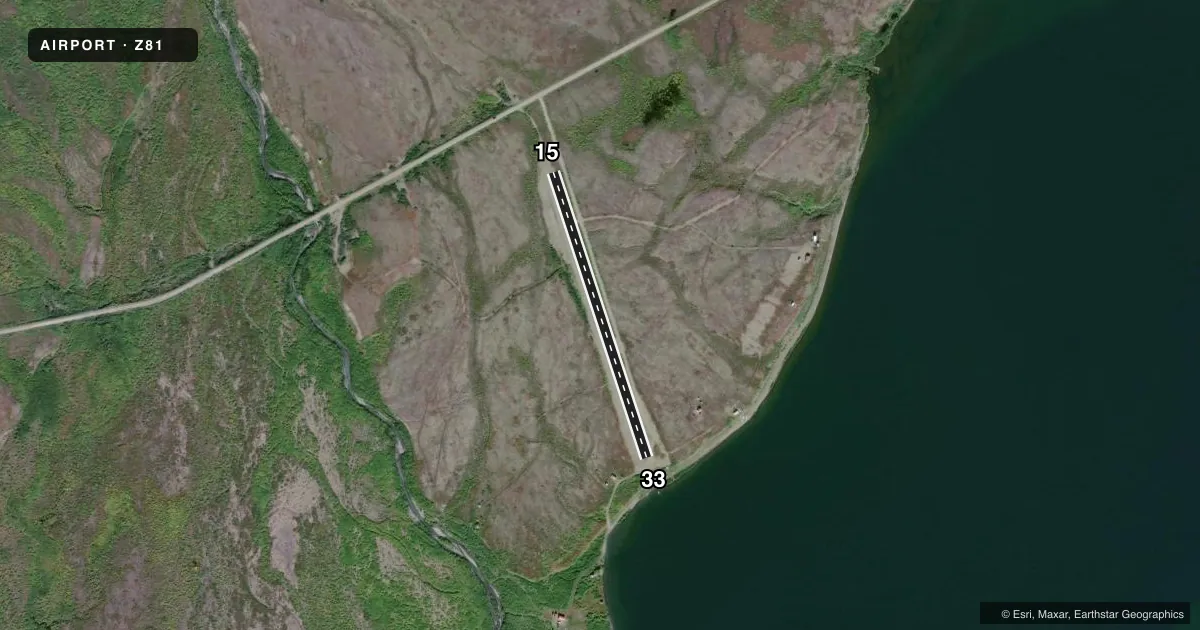
Airport sketch
Runways drawn to scale from FAA survey coordinates, rendered over satellite imagery. Not for navigation.
Approaches & charts
Services on the field
Fuel grades, oxygen, maintenance, ramp storage and lighting — as declared to the FAA by the airport operator.
Fuel & services
- Fuel
- Not available
Ramp & ground
- Transient storage
- Not published
- Landing fee
- No fee published
- Customs
- Not available
- Wind indicator
- Yes
- Segmented circle
- No
Fuel & FBOs
Cheapest 100LL and Jet A on the field and nearby. Always confirm with the FBO before taxi.
Airport notes
Surface conditions, obstructions, local procedures, lighting outages and other notes published with each FAA cycle.
General notes
- RWY MAINT NA. RWY COND UNMNT, RCMD VISUAL INSP BFR USE.
- HIGH TRRN ALL QUADS.
Runway surface & condition
- 15/33SLOPES 40 FT UPHILL SE TO NW.
Approach & departure obstructions
- 33RWY END ROCKY.
- 15CONES & THR PANELS.
- 33CONES & THR PANELS.
Other notes
- ESTABD PRIOR TO 1959.
- 15/33SOFT WHEN WET.
- 15/33NMRS 6 IN ROCKS.
VFR map & nearby airports
VFR sectional. Tap any ICAO chip to open that airport.
Key facts · Z81
Answer card- ICAO
- Z81
- Name
- SALMON LAKE
- Location
- SALMON LAKE, ALASKA
- Elevation
- 509 ft MSL
- Traffic pattern altitude
- 1,509 ft MSL (1,000 AGL)
- Control tower
- Non-towered (use CTAF)
- Total runways
- 1
- Longest runway
- 15/33 · 2,000 ft
- Published ILS approaches
- 0
- Published frequencies
- 1
- Magnetic variation
- 17°
- Current flight rules
- VFR
- Current wind
- 190° at 9 kt
- Favored runway now
- RWY 15
Salmon Lake Airport sits in Salmon Lake, Alaska. Field elevation is 509 ft MSL. The airport has one runway. Runway 15/33 is 2,000 ft long and gravel. This is a non-towered field, so CTAF 122.9 is the main traffic advisory frequency.
No ILS approaches are published here. Pattern altitude is not published in the facts, so use the current Chart Supplement before you go. The field uses magnetic variation of 17°. Runway 15/33 is reported to slope 40 ft uphill from southeast to northwest. Runway end 33 is rocky. Runway end 15 and runway end 33 are marked with cones and threshold panels. The surface is described as having numerous 6 inch rocks. It is also noted that the surface can be soft when wet. Runway condition is unmonitored. A visual inspection is recommended before use.
There are no on-field FBOs listed. Check with the airport operator or the FBO directly by phone if you need current services. High terrain exists in all quadrants, so plan your arrival and departure with that in mind. This is a backcountry-style strip where a careful look at the runway and surrounding terrain matters before committing.