METAR & TAF PATE
Current METAR
Observed 14:56Z
PATE 281456Z AUTO 25011KT 10SM OVC002 07/07 A2993 RMK AO2 RAE1357 SLP139 60000 T00720072 53002
- Wind
- 250° @ 11 kt
- Visibility
- 10 SM
- Temp / Dew
- 7°C / 7°C
- Altimeter
- 29.93 inHg
- Clouds
- OVC
- Density alt
- -602 ft
- Ceiling
- 200 ft AGL
- Rules
- LIFR
Airport info & contacts
Manager on record, flight service, ARTCC, attendance schedule and pattern altitude — published by the FAA and refreshed every 28 days.
Location
- From city
- 2 NM S
- VFR sectional
- NOME
- ARTCC
- ZAN · ANCHORAGE
- NOTAM facility
- TER (NOTAM-D)
Airport manager
- Name
- GEORGE KOST
- Phone
- 907-443-3431
- Address
- PO BOX 1048, NOME AK 99762
Flight service · Hours
- FSS OME
- NOMELC 443-22911-800-478-8400
- Attendance
- Unattended
Frequencies
Tap any row to copy the frequency to your clipboard.
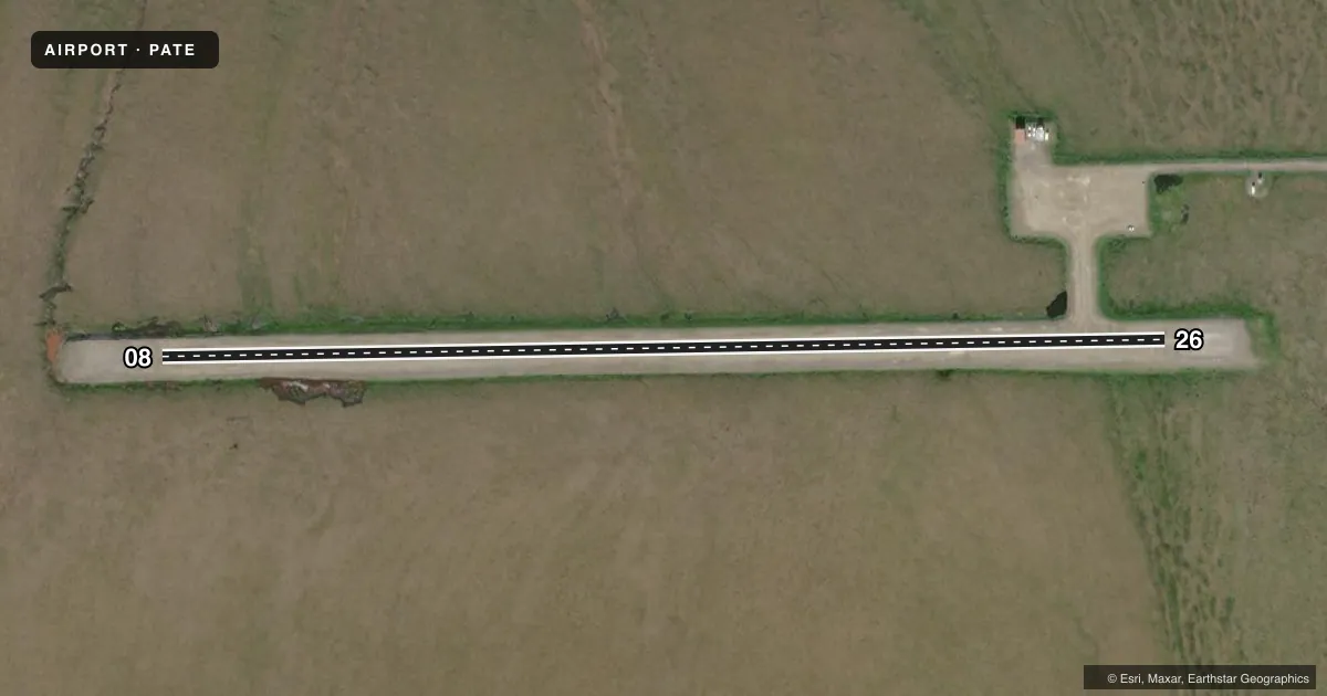
Runways & pattern
Full pagePattern entry · RWY 26
LEFT TRAFFICAirport sketch
Runways drawn to scale from FAA survey coordinates, rendered over satellite imagery. Not for navigation.
Approaches & charts
Services on the field
Fuel grades, oxygen, maintenance, ramp storage and lighting — as declared to the FAA by the airport operator.
Fuel & services
- Fuel
- Not available
Ramp & ground
- Transient storage
- Not published
- Landing fee
- No fee published
- Customs
- Not available
- Lighting schedule
- SEE RMK
- Beacon schedule
- SEE RMK
- Beacon
- White / Green (civil land)(WG)
- Wind indicator
- Lighted
- Segmented circle
- Yes
Fuel & FBOs
Cheapest 100LL and Jet A on the field and nearby. Always confirm with the FBO before taxi.
Airport notes
Surface conditions, obstructions, local procedures, lighting outages and other notes published with each FAA cycle.
General notes
- RWY COND UNMNT; RCMD VISUAL INSP PRIOR TO LNDG.
- WX CAMERA AVBL ON INTERNET AT HTTPS://WEATHERCAMS.FAA.GOV
- COLD TEMPERATURE AIRPORT. ALTITUDE CORRECTION REQUIRED AT OR BELOW -35C.
Lighting notes
- ACTVT ROTG BCN - CTAF.
- ACTVT MIRL RWY 08/26 - CTAF.
Approach & departure obstructions
- 08LIGHTS & CONES.
- 26LIGHTS & CONES.
VFR map & nearby airports
VFR sectional. Tap any ICAO chip to open that airport.
Key facts · PATE
Answer card- ICAO
- PATE
- Name
- TELLER
- Location
- TELLER, ALASKA
- Elevation
- 298.5 ft MSL
- Traffic pattern altitude
- 1,298.5 ft MSL (1,000 AGL)
- Control tower
- Non-towered (use CTAF)
- Total runways
- 1
- Longest runway
- 08/26 · 2,983 ft
- Published ILS approaches
- 0
- Published frequencies
- 1
- Magnetic variation
- 9°
- Current flight rules
- LIFR
- Current wind
- 250° at 11 kt
- Favored runway now
- RWY 26
Teller Airport sits in Teller, Alaska. The field elevation is 298.5 ft MSL. It has one runway. Runway 08/26 is 2,983 ft long with a gravel-dirt surface. There is no control tower. CTAF is 123.0.
No ILS approaches are published here. Pattern altitude is not published, so use standard traffic pattern planning unless the current FAA Chart Supplement says otherwise. The airport uses magnetic variation of 9°. The rotating beacon is activated by CTAF. Medium intensity runway lights are also activated by CTAF. The runway 08 end and runway 26 end are marked with lights and cones.
This is a cold temperature airport. Altitude correction is required at or below minus 35 degrees Celsius. Runway condition is unmonitored, so a visual inspection before landing is a good idea. There is also a weather camera available online for a current look at the field. No on-field FBOs are listed, so verify fuel and service options with the airport operator or by calling the field before you go. For any current noise, lighting, or operational notes, check the current FAA Chart Supplement before departure.