METAR & TAF PFKT
Current METAR
Observed 09:56Z
PFKT 280956Z AUTO 18009KT 10SM CLR 09/04 A2993 RMK AO2 SLP134 T00940044 $
- Wind
- 180° @ 9 kt
- Visibility
- 10 SM
- Temp / Dew
- 9°C / 4°C
- Altimeter
- 29.93 inHg
- Clouds
- CLR
- Density alt
- -685 ft
- Ceiling
- Unlimited
- Rules
- VFR
Airport info & contacts
Manager on record, flight service, ARTCC, attendance schedule and pattern altitude — published by the FAA and refreshed every 28 days.
Location
- From city
- 0 NM E
- VFR sectional
- NOME
- ARTCC
- ZAN · ANCHORAGE
- NOTAM facility
- KTS (NOTAM-D)
Airport manager
- Name
- GEORGE KOST
- Phone
- 907-443-2500
- Address
- BOX 1048, NOME AK 99762
Flight service · Hours
- FSS OME
- NOMELC 443-22911-800-478-8400
- Attendance
- Unattended
Frequencies
Tap any row to copy the frequency to your clipboard.
Runways & pattern
Full pagePattern entry · RWY 12
LEFT TRAFFIC| Runway | Heading (°M) | Length | Surface | Traffic |
|---|---|---|---|---|
| 12/30Favored | 121° / 301° | 2,990 ft | GRVL | Standard L |
| 05/23 | 46° / 226° | 2,110 ft | GRVL | Standard L |
Runway end performance
| End | TORA | TODA | ASDA | LDA | VGSI | Approach lights | Obstruction |
|---|---|---|---|---|---|---|---|
| 30 | — | — | — | — | — | — | 28', pole, 1011' from thr, 401' R of cntrln, slope 36 |
| 23 | — | — | — | — | — | — | 1215', hill, 9500' from thr, 0' R of cntrln, slope 8 |
Declared distances in feet. TORA = takeoff run available, TODA = takeoff distance, ASDA = accelerate-stop, LDA = landing distance.
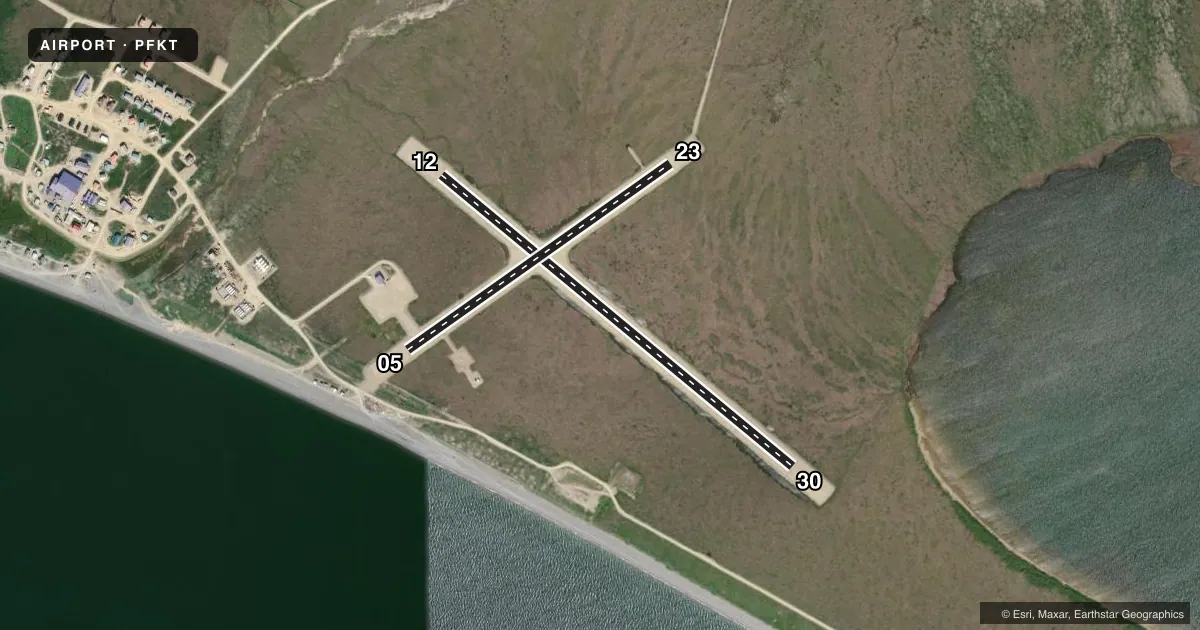
Airport sketch
Runways drawn to scale from FAA survey coordinates, rendered over satellite imagery. Not for navigation.
Approaches & charts
Services on the field
Fuel grades, oxygen, maintenance, ramp storage and lighting — as declared to the FAA by the airport operator.
Fuel & services
- Fuel
- Not available
Ramp & ground
- Transient storage
- Not published
- Lighting schedule
- SEE RMK
- Beacon schedule
- SS-SR
- Beacon
- White / Green (civil land)(WG)
- Wind indicator
- Lighted
- Segmented circle
- Yes
Fuel & FBOs
Cheapest 100LL and Jet A on the field and nearby. Always confirm with the FBO before taxi.
Airport notes
Surface conditions, obstructions, local procedures, lighting outages and other notes published with each FAA cycle.
General notes
- RY COND NOT MONITORED; RCMD VISUAL INSPECTION PRIOR TO LDNG.
Lighting notes
- ACTVT MIRL RWY 05/23 & 12/30 - CTAF.
Approach & departure obstructions
- 05RWY 05/23 MARKED WITH LIGHTS AND PLASTIC MARKERS.
- 12RWY 12/30 MARKED WITH LIGHTS AND PLASTIC MARKERS.
Other notes
- THIS AIRPORT HAS BEEN SURVEYED BY THE NATIONAL GEODETIC SURVEY.
- ESTABD PRIOR TO 1959.
VFR map & nearby airports
VFR sectional. Tap any ICAO chip to open that airport.
Key facts · PFKT
Answer card- ICAO
- PFKT
- Name
- BREVIG MISSION
- Location
- BREVIG MISSION, ALASKA
- Elevation
- 38.1 ft MSL
- Traffic pattern altitude
- 1,038.1 ft MSL (1,000 AGL)
- Control tower
- Non-towered (use CTAF)
- Total runways
- 2
- Longest runway
- 12/30 · 2,990 ft
- Published ILS approaches
- 0
- Published frequencies
- 1
- Magnetic variation
- 9°
- Current flight rules
- VFR
- Current wind
- 180° at 9 kt
- Favored runway now
- RWY 12
Brevig Mission Airport sits in Brevig Mission, Alaska. Field elevation is 38.1 ft MSL. The airport has two gravel runways. The longest is 12/30 at 2,990 ft. There is no control tower. CTAF is 123.0.
No ILS approaches are published here. Pattern altitude is not published, so use the standard 1,000 ft AGL for light piston operations unless the current FAA Chart Supplement says otherwise. The field is in a low-lying coastal setting, so expect weather and surface conditions to matter on short final.
Published remarks say runway condition is not monitored. Plan a visual inspection before landing if you can. Both runways are marked with lights and plastic markers. Medium intensity runway lights for 05/23 and 12/30 are activated on the CTAF. The airport was established prior to 1959.
There are no on-field FBOs listed. Check with the airport operator or call the field directly for current services before you go. For a first visit, pay close attention to the gravel surface. Watch the short field lengths. There is no published instrument approach support.