METAR & TAF PAOM
Current METAR
Observed 06:53Z
PAOM 270653Z AUTO 19009KT 10SM FEW090 13/09 A2982
- Wind
- 190° @ 9 kt
- Visibility
- 10 SM
- Temp / Dew
- 13°C / 9°C
- Altimeter
- 29.82 inHg
- Clouds
- FEW
- Density alt
- -66 ft
- Ceiling
- Unlimited
- Rules
- VFR
Airport info & contacts
Manager on record, flight service, ARTCC, attendance schedule and pattern altitude — published by the FAA and refreshed every 28 days.
Location
- From city
- 2 NM W
- VFR sectional
- NOME
- Pattern altitude
- 1,100 ft AGL · 1,141 ft MSL
- ARTCC
- ZAN · ANCHORAGE
- NOTAM facility
- OME (NOTAM-D)
Airport manager
- Name
- GEORGE KOST
- Phone
- 907-443-2500
- Address
- BOX 1048, NOME AK 99762
Flight service · Hours
- FSS OME
- NOMELC 443-22911-800-478-8400
- Attendance
- 0700-1830
Frequencies
Tap any row to copy the frequency to your clipboard.
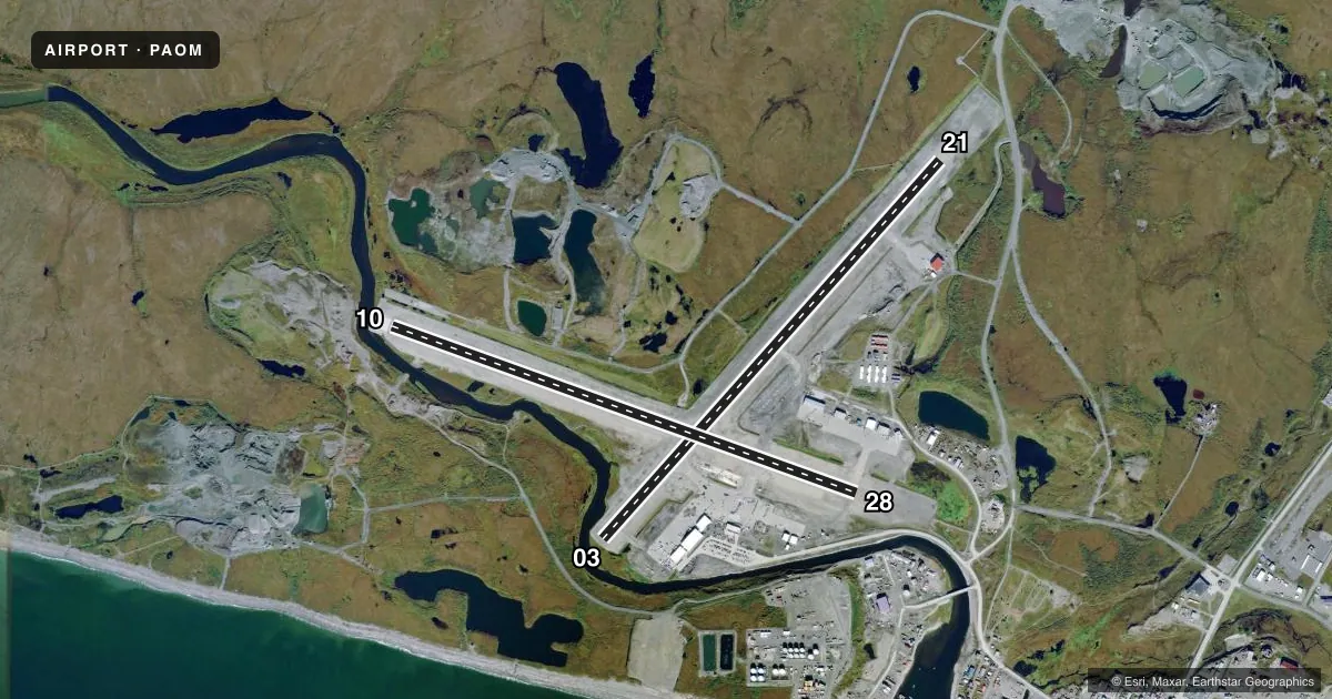
Runways & pattern
Full pagePattern entry · RWY 21
LEFT TRAFFIC| Runway | Heading (°M) | Length | Surface | Traffic |
|---|---|---|---|---|
| 03/21Favored | 31° / 211° | 6,176 ft | ASPH | Standard L |
| 10/28 | 99° / 279° | 6,009 ft | ASPH | Standard L |
Runway end performance
| End | TORA | TODA | ASDA | LDA | VGSI | Approach lights | Obstruction |
|---|---|---|---|---|---|---|---|
| 03 | 6,176' | 6,176' | 6,176' | 5,576' | PAPI 4-box left(3°) | — | 37', road, 528' from thr, 336' R of cntrln, slope 8 |
| 21 | 5,576' | 5,576' | 5,576' | 5,576' | PAPI 4-box left(3°) | — | 69', pole, 2150' from thr, 75' R of cntrln, slope 28 |
| 10 | 6,009' | 6,009' | 6,009' | 6,009' | PAPI 4-box left(3°) | — | 18', hill, 300' from thr, 250' R of cntrln, slope 5 |
| 28 | 6,009' | 6,009' | 6,009' | 6,009' | PAPI 4-box left(3°) | MALSR | 80', hill, 2500' from thr, 0' R of cntrln, slope 28 |
Declared distances in feet. TORA = takeoff run available, TODA = takeoff distance, ASDA = accelerate-stop, LDA = landing distance.
Airport sketch
Runways drawn to scale from FAA survey coordinates, rendered over satellite imagery. Not for navigation.
Approaches & charts
ILS · 1
Services on the field
Fuel grades, oxygen, maintenance, ramp storage and lighting — as declared to the FAA by the airport operator.
Fuel & services
- Fuel
- 100LLAA1+
- Airframe repair
- Minor
- Power plant repair
- Minor
- Other services
- CARGO
Ramp & ground
- Transient storage
- Hangar
- Landing fee
- No fee published
- Customs
- Not available
- Lighting schedule
- SEE RMK
- Beacon schedule
- SS-SR
- Beacon
- White / Green (civil land)(WG)
- Wind indicator
- Yes
- Segmented circle
- Yes
Fuel & FBOs
Cheapest 100LL and Jet A on the field and nearby. Always confirm with the FBO before taxi.
Airport notes
Surface conditions, obstructions, local procedures, lighting outages and other notes published with each FAA cycle.
General notes
- AIRFIELD MAINT SVCS AVBL 0700 -1730; AFT HR - AMGR.
- ANG: AVN OPERG FAC - ANG HNGR 907-387-1800. OPS 1700-0100Z; LTD MAINT & SVCS AVBL.
- BIRDS INVOF ARPT SEP-OCT & MAY-JUN.
- RWY 21 & 28 ARR MNTN TFC PAT ALT TIL FNL.
- ARPT SAND LRGR GRADATION THAN FAA RCMDD/SEE AC150/5200-30.
- 130 FT LGTD WIND TURBINE TWRS 4 NM NNW.
- WX CAMERA AVBL ON INTERNET AT HTTPS://WEATHERCAMS.FAA.GOV
- TSA REG; SEE 49 CFR 1542. GATES & DOORS MUST BE SECURED H24. INFO - AMGR.
Lighting notes
- ACTVT MALSR RWY 28; REIL RWY 03 &10; PAPI RWY 03, 10, & 28; HIRL RWY 10/28; MIRL RWY 03/21 - CTAF. PAPI RWY 21 PAPI OPR CONSLY.
Fuel notes
- 100LLAVBL HRS VRB - AFT HR AMGR.
Runway surface & condition
- 03/21PCR VALUE: 719/F/A/X/T
- 10/28PCR VALUE: 719/F/A/X/T
- 03/2130 IN ABV GND.
- 10/2830 IN ABV GND.
Approach & departure obstructions
- 03APCH SLOPE 26:1 DUE TO 35 FT ROAD 1128 FT FM DTHR.
- 21APCH SLOPE 34:1 DUE TO 69 FT POLE 1550 FT FM DTHR.
- 21PAPI UNUSBL BYD 2 NM FM THR DUE TO RAPIDLY RISING TRRN.
Arresting gear
- 28_EMASENGINEERED MATERIAL ARRESTING SYSTEM (EMAS) 200 FT IN LENGTH BY 170 FT IN WIDTH LCTD AT THE DER 28
Other notes
- ARFF SVC DURG ACR OPS ONLY; ACR OPS MORE THAN 30 PAX SEATS PPR IN WRITING - AMGR PO BOX 1048 NOME AK 99762.
VFR map & nearby airports
VFR sectional. Tap any ICAO chip to open that airport.
Key facts · PAOM
Answer card- ICAO
- PAOM
- Name
- NOME
- Location
- NOME, ALASKA
- Elevation
- 40.6 ft MSL
- Traffic pattern altitude
- 1,140.6 ft MSL (1,100 AGL)
- Control tower
- Non-towered (use CTAF)
- Total runways
- 2
- Longest runway
- 03/21 · 6,176 ft
- Published ILS approaches
- 1
- Published frequencies
- 1
- Magnetic variation
- 11°
- Current flight rules
- VFR
- Current wind
- 190° at 9 kt
- Favored runway now
- RWY 21
Nome Airport sits in Nome, Alaska. Field elevation is 40.6 ft MSL. This is a two-runway field with the longest runway at 6,176 ft. The airport is non-towered, so traffic runs on CTAF 123.6. Pattern altitude is 1,100 ft AGL, which is 1,140.6 ft MSL.
Runway 03/21 is 6,176 ft of asphalt. Runway 10/28 is 6,009 ft of asphalt. There is one ILS approach. It is for runway 28. That matters here because runway 28 also has MALSR lighting. PAPI is available for runways 03, 10 and 28. REIL is available for runways 03 and 10. Runway 21 has a PAPI that is operated continuously. The field is TSA regulated. Gates and doors must be secured at all times. Aircraft rescue and fire fighting is provided only during aircraft operations.
On the field, Bering Air carries AVGAS 100LL, JET A and JET A PRIST. Crowley Aviation Fuels is also on the field with the same fuel grades. Nome is in a coastal Alaska environment, so weather and surface conditions can change fast. The airport also notes rising terrain on the runway 21 side, which can affect visual cues on final. Check the current FAA Chart Supplement and the airport operator for any current operational limits before you go.