METAR & TAF PAIW
Current METAR
Observed 16:56Z
PAIW 281656Z AUTO 01010KT 10SM OVC013 06/06 A2997 RMK AO2 SLP148 T00560056
- Wind
- 010° @ 10 kt
- Visibility
- 10 SM
- Temp / Dew
- 6°C / 6°C
- Altimeter
- 29.97 inHg
- Clouds
- OVC
- Density alt
- -1,110 ft
- Ceiling
- 1,300 ft AGL
- Rules
- MVFR
Airport info & contacts
Manager on record, flight service, ARTCC, attendance schedule and pattern altitude — published by the FAA and refreshed every 28 days.
Location
- From city
- 1 NM NW
- VFR sectional
- NOME
- ARTCC
- ZAN · ANCHORAGE
- NOTAM facility
- IWK (NOTAM-D)
Airport manager
- Name
- GEORGE KOST
- Phone
- 907-443-3431
- Address
- PO BOX 1048, NOME AK 99762
Flight service · Hours
- FSS OME
- NOMELC 443-22911-800-478-8400
- Attendance
- Unattended
Frequencies
Tap any row to copy the frequency to your clipboard.
Runways & pattern
Full pagePattern entry · RWY 36
LEFT TRAFFICRunway end performance
| End | TORA | TODA | ASDA | LDA | VGSI | Approach lights | Obstruction |
|---|---|---|---|---|---|---|---|
| 18 | — | — | — | — | PAPI 4-box left(3°) | — | — |
| 36 | — | — | — | — | PAPI 4-box right(3°) | — | 15', road, 600' from thr, 0' R of cntrln, slope 40 |
Declared distances in feet. TORA = takeoff run available, TODA = takeoff distance, ASDA = accelerate-stop, LDA = landing distance.
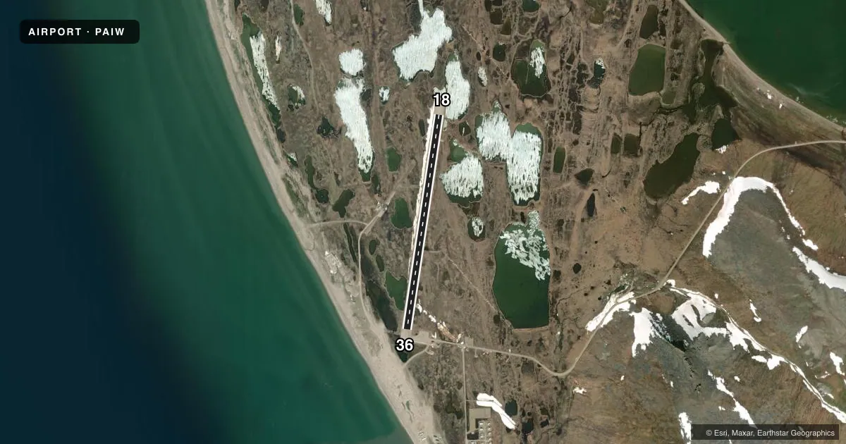
Airport sketch
Runways drawn to scale from FAA survey coordinates, rendered over satellite imagery. Not for navigation.
Approaches & charts
Services on the field
Fuel grades, oxygen, maintenance, ramp storage and lighting — as declared to the FAA by the airport operator.
Fuel & services
- Fuel
- Not available
- Oxygen (bottled)
- Not available
- Oxygen (bulk)
- Not available
- Airframe repair
- Not available
- Power plant repair
- Not available
Ramp & ground
- Transient storage
- Not published
- Landing fee
- No fee published
- Customs
- Not available
- Lighting schedule
- SEE RMK
- Beacon schedule
- SS-SR
- Beacon
- White / Green (civil land)(WG)
- Wind indicator
- Lighted
- Segmented circle
- Yes
Fuel & FBOs
Cheapest 100LL and Jet A on the field and nearby. Always confirm with the FBO before taxi.
Airport notes
Surface conditions, obstructions, local procedures, lighting outages and other notes published with each FAA cycle.
General notes
- EASTERLY WINDS MAY CAUSE SEVERE TURBULENCE IN VICINITY OF RWY.
- HIGH TERRAIN SE THRU E.
- RY CONDITIONS NOT MONITORED; RECOMMEND VISUAL INSPECTION PRIOR TO LANDING.
- WX CAMERA AVBL ON INTERNET AT HTTPS://WEATHERCAMS.FAA.GOV
- COLD TEMPERATURE AIRPORT. ALTITUDE CORRECTION REQUIRED AT OR BELOW -26C.
- WIND SOCK LIGHTING INOPERATIVE, WIND SOCK MAY BE MISSING
- SEVERAL RWY LIGHTS BROKEN.
Lighting notes
- ACTVT MIRL RY 18/36; PAPI AND REIL RYS 18 & 36 - CTAF.
Other notes
- WIND SOCK LGT MAY BE OTS.
VFR map & nearby airports
VFR sectional. Tap any ICAO chip to open that airport.
Key facts · PAIW
Answer card- ICAO
- PAIW
- Name
- WALES
- Location
- WALES, ALASKA
- Elevation
- 25.8 ft MSL
- Traffic pattern altitude
- 1,025.8 ft MSL (1,000 AGL)
- Control tower
- Non-towered (use CTAF)
- Total runways
- 1
- Longest runway
- 18/36 · 3,990 ft
- Published ILS approaches
- 0
- Published frequencies
- 1
- Magnetic variation
- 8°
- Current flight rules
- MVFR
- Current wind
- 010° at 10 kt
- Favored runway now
- RWY 36
Wales Airport sits in Wales, Alaska. The field elevation is 25.8 ft MSL. It has one runway. Runway 18/36 is 3,990 ft long and gravel. There is no control tower. CTAF is 123.0.
No ILS approaches are published here. The pattern altitude is not published, so use the standard 1,000 ft AGL for light piston ops unless the current Chart Supplement says otherwise. The airport is in a cold area. Altitude correction is required at or below minus 26 degrees Celsius. High terrain is located southeast through east of the airport. That matters on departure and when planning a low pass or go-around.
Published remarks also call out several runway lights that are broken. Runway conditions are not monitored, so a visual inspection before landing is a smart move. Easterly winds may bring severe turbulence near runway 18/36. The wind sock light may be out of service. The wind sock may also be missing. Medium intensity runway lights are activated on runway 18/36. PAPI and REIL are activated on runways 18 and 36 via CTAF. There are no on-field FBOs listed, so contact the airport operator directly before arrival if you need fuel or other services.