METAR & TAF PASH
Current METAR
Observed 04:56Z
PASH 280456Z AUTO 30013KT 6SM BR CLR 05/03 A2993 RMK AO2 SLP137 T00500033
- Wind
- 300° @ 13 kt
- Visibility
- 6 SM
- Temp / Dew
- 5°C / 3°C
- Altimeter
- 29.93 inHg
- Clouds
- CLR
- Density alt
- -1,195 ft
- Ceiling
- Unlimited
- Rules
- VFR
Airport info & contacts
Manager on record, flight service, ARTCC, attendance schedule and pattern altitude — published by the FAA and refreshed every 28 days.
Location
- From city
- 1 NM S
- VFR sectional
- NOME
- ARTCC
- ZAN · ANCHORAGE
- NOTAM facility
- SHH (NOTAM-D)
Airport manager
- Name
- GEORGE KOST
- Phone
- 907-443-2500
- Address
- PO BOX 1048, NOME AK 99762
Flight service · Hours
- FSS OME
- NOMELC 443-22911-800-478-8400
- Attendance
- Unattended
Frequencies
Tap any row to copy the frequency to your clipboard.
Runways & pattern
Full pagePattern entry · RWY 23
LEFT TRAFFICRunway end performance
| End | TORA | TODA | ASDA | LDA | VGSI | Approach lights | Obstruction |
|---|---|---|---|---|---|---|---|
| 05 | — | — | — | — | VASI 4-box left(3°) | — | — |
| 23 | — | — | — | — | VASI 4-box left(3°) | — | 42', ant, 625' from thr, 325' R of cntrln, slope 10 |
Declared distances in feet. TORA = takeoff run available, TODA = takeoff distance, ASDA = accelerate-stop, LDA = landing distance.
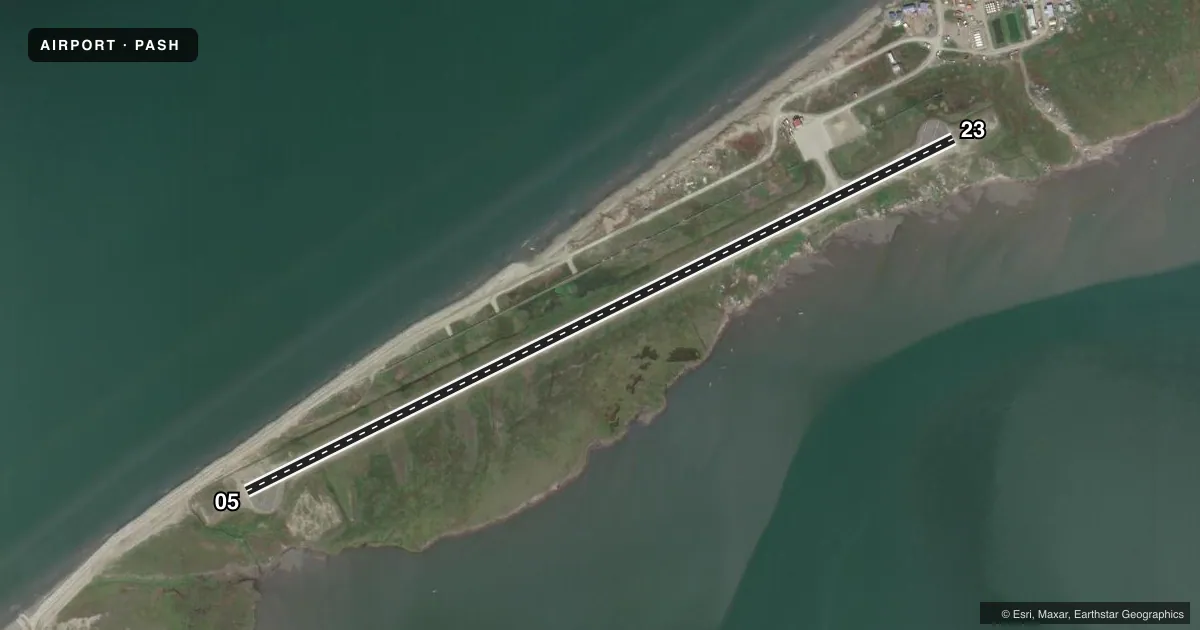
Airport sketch
Runways drawn to scale from FAA survey coordinates, rendered over satellite imagery. Not for navigation.
Approaches & charts
Services on the field
Fuel grades, oxygen, maintenance, ramp storage and lighting — as declared to the FAA by the airport operator.
Fuel & services
- Fuel
- Not available
Ramp & ground
- Transient storage
- Not published
- Lighting schedule
- SEE RMK
- Beacon schedule
- SS-SR
- Beacon
- White / Green (civil land)(WG)
- Wind indicator
- Lighted
- Segmented circle
- Yes
Fuel & FBOs
Cheapest 100LL and Jet A on the field and nearby. Always confirm with the FBO before taxi.
Airport notes
Surface conditions, obstructions, local procedures, lighting outages and other notes published with each FAA cycle.
General notes
- NW-SE PVLG WINDS.
- WX CAMERA AVBL ON INTERNET AT HTTPS://WEATHERCAMS.FAA.GOV
- RWY COND UNMNT; RCMD VISUAL INSP PRIOR TO LNDG.
- BIRDS ON & INVOF ARPT 1 MAY - 31 OCT.
- HVY ACFT SINK IN RAMP BLACKTOP ON HOT DAYS.
Lighting notes
- ACTVT MIRL RWY 05/23 - CTAF. VASI RWY 05 & 23; ON CONSLY.
Runway surface & condition
- 05/23MAX ACFT WGT; NO LMT WHEN FROZEN.
Approach & departure obstructions
- 05FADED.
- 23FADED.
VFR map & nearby airports
VFR sectional. Tap any ICAO chip to open that airport.
Key facts · PASH
Answer card- ICAO
- PASH
- Name
- SHISHMAREF
- Location
- SHISHMAREF, ALASKA
- Elevation
- 13.9 ft MSL
- Traffic pattern altitude
- 1,013.9 ft MSL (1,000 AGL)
- Control tower
- Non-towered (use CTAF)
- Total runways
- 1
- Longest runway
- 05/23 · 4,997 ft
- Published ILS approaches
- 0
- Published frequencies
- 1
- Magnetic variation
- 7°
- Current flight rules
- VFR
- Current wind
- 300° at 13 kt
- Favored runway now
- RWY 23
Shishmaref Airport sits in Shishmaref, Alaska. Field elevation is 13.9 ft MSL. The airport has one runway. Runway 05/23 is 4,997 ft long and asphalt. There is no control tower. CTAF is 123.0. No ILS approaches are published here.
Pattern altitude is not published. Use 1,000 ft AGL for light piston operations unless the current FAA Chart Supplement says otherwise. Runway headings are magnetic. Runway 05 is 063° magnetic. Runway 23 is 244° magnetic. Published remarks say runway condition is unmonitored, so a visual check before landing is a good idea. Markings on both ends are faded. Medium intensity runway lights are on 05/23 and are activated by CTAF. VASI is installed on both runway ends and is on continuously.
This is a coastal Alaska field with low elevation. Weather and surface conditions can change fast. Birds are reported on and near the airport from May 1 to October 31. Heavy aircraft can sink into the ramp blacktop on hot days. The runway has a published maximum aircraft weight note. No on-field FBOs are listed, so verify services with the airport operator or the field directly before arrival.