METAR & TAF PFNO
Current METAR
Observed 10:56Z
PFNO 281056Z AUTO 19005KT 6SM BR CLR 08/07 A2982 RMK AO2 SLP096 T00830072 $
- Wind
- 190° @ 5 kt
- Visibility
- 6 SM
- Temp / Dew
- 8°C / 7°C
- Altimeter
- 29.82 inHg
- Clouds
- CLR
- Density alt
- -648 ft
- Ceiling
- Unlimited
- Rules
- VFR
Airport info & contacts
Manager on record, flight service, ARTCC, attendance schedule and pattern altitude — published by the FAA and refreshed every 28 days.
Location
- From city
- 1 NM SE
- VFR sectional
- NOME
- ARTCC
- ZAN · ANCHORAGE
- NOTAM facility
- D76 (NOTAM-D)
Airport manager
- Name
- ALVIN WERNEKE
- Phone
- 907-442-3147
- Address
- BOX 55, KOTZEBUE AK 99752
Flight service · Hours
- FSS OTZ
- KOTZEBUE907-442-33101-800-478-7460
- Attendance
- Unattended
Frequencies
Tap any row to copy the frequency to your clipboard.
Runways & pattern
Full pagePattern entry · RWY 24
LEFT TRAFFICRunway end performance
| End | TORA | TODA | ASDA | LDA | VGSI | Approach lights | Obstruction |
|---|---|---|---|---|---|---|---|
| 06 | — | — | — | — | PAPI 4-box right(3°) | — | — |
Declared distances in feet. TORA = takeoff run available, TODA = takeoff distance, ASDA = accelerate-stop, LDA = landing distance.
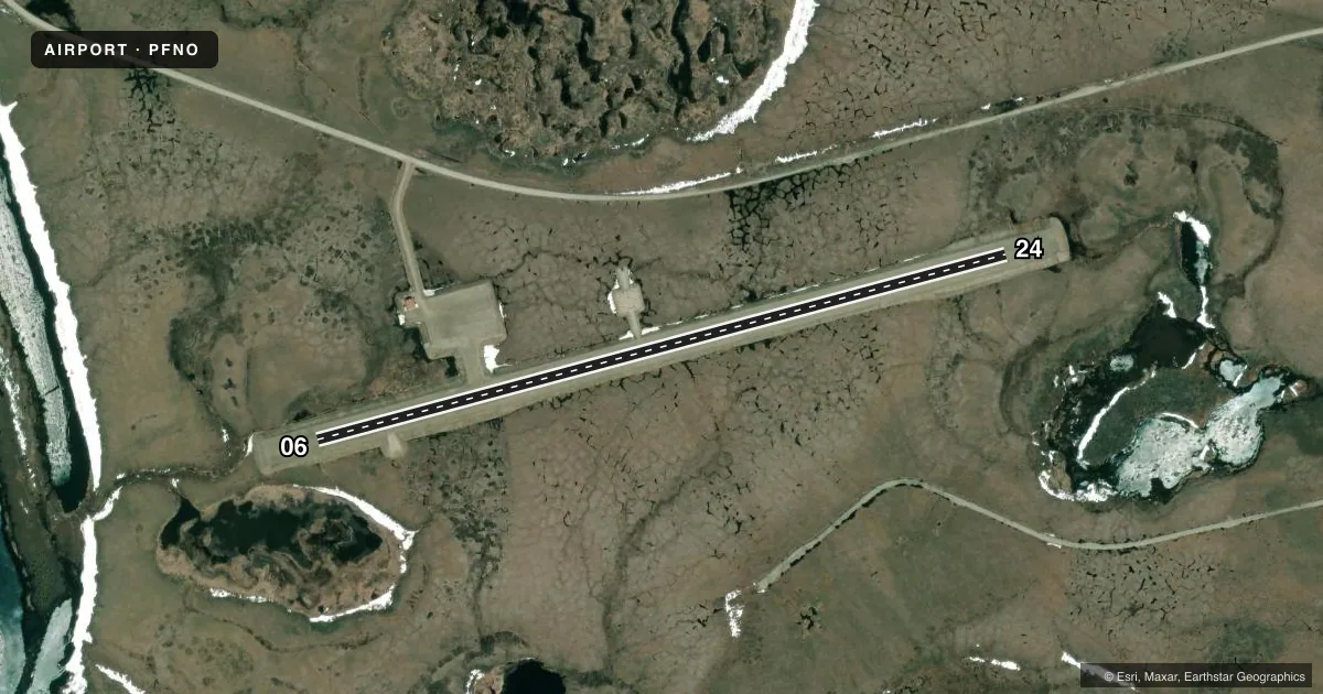
Airport sketch
Runways drawn to scale from FAA survey coordinates, rendered over satellite imagery. Not for navigation.
Approaches & charts
Services on the field
Fuel grades, oxygen, maintenance, ramp storage and lighting — as declared to the FAA by the airport operator.
Fuel & services
- Fuel
- Not available
Ramp & ground
- Transient storage
- Not published
- Lighting schedule
- SEE RMK
- Beacon schedule
- SS-SR
- Beacon
- White / Green (civil land)(WG)
- Wind indicator
- Lighted
- Segmented circle
- Yes
Fuel & FBOs
Cheapest 100LL and Jet A on the field and nearby. Always confirm with the FBO before taxi.
Airport notes
Surface conditions, obstructions, local procedures, lighting outages and other notes published with each FAA cycle.
General notes
- WINTER SNOW REMOVAL - MNT CTAF.
- RWY COND UNMNTD; RCMD VISUAL INSP BFR LNDG.
- COLD TEMPERATURE AIRPORT. ALTITUDE CORRECTION REQUIRED AT OR BELOW -22C.
Lighting notes
- ACTVT PAPI RWY 06; MIRL RWY 06/24 - CTAF
Approach & departure obstructions
- 06LGTS & PLASTIC MKRS.
- 24LGTS & PLASTIC MKRS.
Other notes
- THIS AIRPORT HAS BEEN SURVEYED BY THE NATIONAL GEODETIC SURVEY.
- NORTHWEST ARCTIC BOROUGH
- TIE DOWN NOT AVBL.
VFR map & nearby airports
VFR sectional. Tap any ICAO chip to open that airport.
Key facts · PFNO
Answer card- ICAO
- PFNO
- Name
- ROBERT/BOB/CURTIS MEML
- Location
- NOORVIK, ALASKA
- Elevation
- 54.5 ft MSL
- Traffic pattern altitude
- 1,054.5 ft MSL (1,000 AGL)
- Control tower
- Non-towered (use CTAF)
- Total runways
- 1
- Longest runway
- 06/24 · 4,000 ft
- Published ILS approaches
- 0
- Published frequencies
- 1
- Magnetic variation
- 11°
- Current flight rules
- VFR
- Current wind
- 190° at 5 kt
- Favored runway now
- RWY 24
Robert/Bob/Curtis Meml Airport sits in Noorvik, Alaska. The field elevation is 54.5 ft MSL. It has one runway. Runway 06/24 is 4,000 ft long with a gravel-dirt surface. The runway headings are 75° and 255° magnetic. There is no control tower. CTAF is 122.7.
No ILS approaches are published here. Pattern altitude is not published. Use the standard 1,000 ft AGL for light piston traffic unless the current Chart Supplement says otherwise. The field has runway lights on 06 and 24. PAPI is available on runway 06. Lighting is activated by CTAF. Runway 06 also has plastic markers. Runway 24 has lights and plastic markers.
This is a cold temperature airport. Altitude correction is required at or below minus 22 degrees Celsius. Winter snow removal is maintained by CTAF. Runway condition is unmonitored. A visual inspection before landing is recommended. Tie down is not available. There are no on-field FBOs listed. Verify services with the airport operator or the FBO directly by phone before arrival. For a first visit, plan for a non-towered Arctic field. Expect a gravel surface. Winter conditions can change the runway fast.