METAR & TAF PAIK
Current METAR
Observed 09:56Z
PAIK 280956Z AUTO 18004KT 10SM CLR 14/07 A2983 RMK AO2 SLP098 T01390067
- Wind
- 180° @ 4 kt
- Visibility
- 10 SM
- Temp / Dew
- 14°C / 7°C
- Altimeter
- 29.83 inHg
- Clouds
- CLR
- Density alt
- 213 ft
- Ceiling
- Unlimited
- Rules
- VFR
Airport info & contacts
Manager on record, flight service, ARTCC, attendance schedule and pattern altitude — published by the FAA and refreshed every 28 days.
Location
- From city
- 1 NM N
- VFR sectional
- NOME
- ARTCC
- ZAN · ANCHORAGE
- NOTAM facility
- IAN (NOTAM-D)
Airport manager
- Name
- ALVIN WERNEKE
- Phone
- 907-442-3147
- Address
- BOX 55, KOTZEBUE AK 99752
Flight service · Hours
- FSS OTZ
- KOTZEBUE907-442-33101-800-478-7460
- Attendance
- Unattended
Frequencies
Tap any row to copy the frequency to your clipboard.
Runways & pattern
Full pagePattern entry · RWY 25
LEFT TRAFFICRunway end performance
| End | TORA | TODA | ASDA | LDA | VGSI | Approach lights | Obstruction |
|---|---|---|---|---|---|---|---|
| 25 | — | — | — | — | PAPI 4-box right(3°) | — | 6', brush, 89' from thr, 95' R of cntrln, slope 14 |
Declared distances in feet. TORA = takeoff run available, TODA = takeoff distance, ASDA = accelerate-stop, LDA = landing distance.
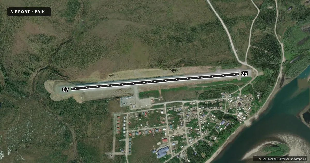
Airport sketch
Runways drawn to scale from FAA survey coordinates, rendered over satellite imagery. Not for navigation.
Approaches & charts
Services on the field
Fuel grades, oxygen, maintenance, ramp storage and lighting — as declared to the FAA by the airport operator.
Fuel & services
- Fuel
- Not available
- Oxygen (bottled)
- Not available
- Oxygen (bulk)
- Not available
- Airframe repair
- Not available
- Power plant repair
- Not available
- Other services
- CHTR
Ramp & ground
- Transient storage
- Not published
- Landing fee
- No fee published
- Customs
- Not available
- Lighting schedule
- SEE RMK
- Beacon schedule
- SEE RMK
- Beacon
- White / Green (civil land)(WG)
- Wind indicator
- Lighted
- Segmented circle
- Yes
Fuel & FBOs
Cheapest 100LL and Jet A on the field and nearby. Always confirm with the FBO before taxi.
Airport notes
Surface conditions, obstructions, local procedures, lighting outages and other notes published with each FAA cycle.
General notes
- RWY CONDITION NOT MONITORED; RECOMMEND VISUAL INSPECTION PRIOR TO LANDING.
- RWY PLOWED IN WINTER.
- WX CAMERA AVBL ON INTERNET AT HTTPS://WEATHERCAMS.FAA.GOV
- COLD TEMPERATURE AIRPORT. ALTITUDE CORRECTION REQUIRED AT OR BELOW -28C.
Lighting notes
- ACTVT ROTG BCN - CTAF.
- ACTVT REIL RWY 25; PAPI RWY 25; MIRL RWY 07/25 - CTAF.
Runway surface & condition
- 07/25RWY SLOPES DOWN FROM 07 TO 25, GRADE 1%.
Approach & departure obstructions
- 07RWY 07/25 MARKED WITH LIGHTS AND PLASTIC MARKERS.
Other notes
- NORTHWEST ARCTIC BOROUGH
VFR map & nearby airports
VFR sectional. Tap any ICAO chip to open that airport.
Key facts · PAIK
Answer card- ICAO
- PAIK
- Name
- BOB BAKER MEML
- Location
- KIANA, ALASKA
- Elevation
- 178.7 ft MSL
- Traffic pattern altitude
- 1,178.7 ft MSL (1,000 AGL)
- Control tower
- Non-towered (use CTAF)
- Total runways
- 1
- Longest runway
- 07/25 · 4,000 ft
- Published ILS approaches
- 0
- Published frequencies
- 1
- Magnetic variation
- 12°
- Current flight rules
- VFR
- Current wind
- 180° at 4 kt
- Favored runway now
- RWY 25
Bob Baker Meml Airport sits in Kiana, Alaska in the Northwest Arctic Borough. Field elevation is 178.7 ft MSL. The airport has one runway. Runway 07/25 is 4,000 ft long and gravel. The longest runway is 4,000 ft. There is no control tower, so use CTAF 122.7 for traffic calls.
No ILS approaches are published here. The published pattern altitude is not listed, so a standard 1,000 ft AGL pattern is often used for light piston operations. Verify the current pattern and any local procedures before you go. The runway is marked with lights and plastic markers. Runway 25 has runway end identifier lights and a PAPI. Medium intensity runway lights are on runway 07/25 and are activated on CTAF. The rotating beacon is also activated on CTAF.
This is a cold temperature airport. Altitude correction is required at or below minus 28 degrees Celsius. The runway slopes down from 07 to 25 by 1 percent. Runway condition is not monitored, so a visual inspection before landing is smart. The runway is plowed in winter. No on-field FBOs are listed, so contact the airport operator directly or call the field on CTAF for current services before arrival.