METAR & TAF PAKV
Current METAR
Observed 02:53Z
PAKV 280253Z AUTO 24012G19KT 10SM -RA OVC085 13/11 A2982 RMK AO2 SLP099 P0001 60001 T01330111 50003 TSNO $
- Wind
- 240° @ 12G19 kt
- Visibility
- 10 SM
- Temp / Dew
- 13°C / 11°C
- Altimeter
- 29.82 inHg
- Clouds
- OVC
- Density alt
- 109 ft
- Ceiling
- 8,500 ft AGL
- Rules
- VFR
Airport info & contacts
Manager on record, flight service, ARTCC, attendance schedule and pattern altitude — published by the FAA and refreshed every 28 days.
Location
- From city
- 1 NM SW
- VFR sectional
- NOME
- ARTCC
- ZAN · ANCHORAGE
- NOTAM facility
- KAL (NOTAM-D)
Airport manager
- Name
- JASON LUDINGTON
- Phone
- 907-451-5280
- Address
- 2301 PEGER ROAD, FAIRBANKS AK 99701
Flight service · Hours
- FSS FAI
- FAIRBANKS907-474-07881-866-248-6516
- Attendance
- Unattended
Frequencies
Tap any row to copy the frequency to your clipboard.
Runways & pattern
Full pagePattern entry · RWY 21
LEFT TRAFFICRunway end performance
| End | TORA | TODA | ASDA | LDA | VGSI | Approach lights | Obstruction |
|---|---|---|---|---|---|---|---|
| 03 | — | — | — | — | — | — | 7', brush, 0' from thr, 85' R of cntrln, slope 0 |
| 21 | — | — | — | — | — | — | 15', road, 0' from thr, 150' R of cntrln, slope 0 |
Declared distances in feet. TORA = takeoff run available, TODA = takeoff distance, ASDA = accelerate-stop, LDA = landing distance.
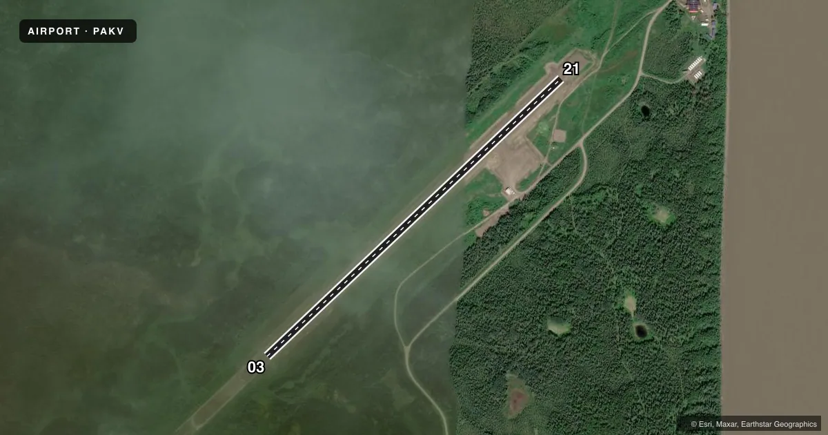
Airport sketch
Runways drawn to scale from FAA survey coordinates, rendered over satellite imagery. Not for navigation.
Approaches & charts
Services on the field
Fuel grades, oxygen, maintenance, ramp storage and lighting — as declared to the FAA by the airport operator.
Fuel & services
- Fuel
- Not available
Ramp & ground
- Transient storage
- Tie-down
- Landing fee
- No fee published
- Customs
- Not available
- Lighting schedule
- SEE RMK
- Wind indicator
- Lighted
- Segmented circle
- Yes
Fuel & FBOs
Cheapest 100LL and Jet A on the field and nearby. Always confirm with the FBO before taxi.
Airport notes
Surface conditions, obstructions, local procedures, lighting outages and other notes published with each FAA cycle.
General notes
- RWY COND UNMNT; RCMD VISUAL INSP PRIOR TO LNDG.
- SNOW REMOVAL OPS - CTAF.
- WX CAMERA AVBL ON INTERNET AT HTTPS://WEATHERCAMS.FAA.GOV
- COLD TEMPERATURE AIRPORT. ALTITUDE CORRECTION REQUIRED AT OR BELOW -31C.
Lighting notes
- ACTVT MIRL RWT 03/21 - CTAF.
Runway surface & condition
- 03/21NORTH 3900 FT LGT.
Approach & departure obstructions
- 03CONES.
- 21CONES.
Other notes
- 03/21SOFT WHEN WET.
VFR map & nearby airports
VFR sectional. Tap any ICAO chip to open that airport.
Key facts · PAKV
Answer card- ICAO
- PAKV
- Name
- KALTAG
- Location
- KALTAG, ALASKA
- Elevation
- 181.1 ft MSL
- Traffic pattern altitude
- 1,181.1 ft MSL (1,000 AGL)
- Control tower
- Non-towered (use CTAF)
- Total runways
- 1
- Longest runway
- 03/21 · 3,986 ft
- Published ILS approaches
- 0
- Published frequencies
- 1
- Magnetic variation
- 18°
- Current flight rules
- VFR
- Current wind
- 240° at 12 kt
- Favored runway now
- RWY 21
Kaltag Airport sits in Kaltag, Alaska. Field elevation is 181.1 ft MSL. The airport has one runway. Runway 03/21 is 3,986 ft long and surfaced with gravel. There is no control tower. CTAF is 122.9.
No ILS approaches are published here. Pattern altitude is not published, so use the standard 1,000 ft AGL for light piston operations unless the current Chart Supplement says otherwise. The runway is lighted. Medium intensity runway lights on 03/21 are activated by CTAF. Runway condition is not monitored, so a visual inspection before landing is a good idea. The runway surface can be soft when wet. Cones mark the ends of both runway directions.
There are no on-field FBOs listed. Plan on self-sufficiency and verify current services with the airport operator before you go. Snow removal operations are conducted on CTAF. This is also a cold temperature airport. Altitude correction is required at or below minus 31 degrees Celsius. If you are arriving in winter or during a cold snap, factor that into your performance planning. A weather camera is available online for a quick look before departure.