METAR & TAF PAHX
Current METAR
Observed 08:02Z
PAHX 280802Z AUTO 24008G15KT 10SM BKN043 OVC060 12/09 A2998 RMK AO2 SLP152 T01220089 401220122
- Wind
- 240° @ 8G15 kt
- Visibility
- 10 SM
- Temp / Dew
- 12°C / 9°C
- Altimeter
- 29.98 inHg
- Clouds
- OVC
- Density alt
- -337 ft
- Ceiling
- 4,300 ft AGL
- Rules
- VFR
Airport info & contacts
Manager on record, flight service, ARTCC, attendance schedule and pattern altitude — published by the FAA and refreshed every 28 days.
Location
- From city
- 1 NM N
- VFR sectional
- MC GRATH
- ARTCC
- ZAN · ANCHORAGE
- NOTAM facility
- SHX (NOTAM-D)
Airport manager
- Name
- ERIK WEINGARTH
- Phone
- 907-438-2416
- Address
- PO BOX 192, UNALAKLEET AK 99684
Flight service · Hours
- FSS ENA
- KENAI907-283-72111-866-864-1737
- Attendance
- Unattended
Frequencies
Tap any row to copy the frequency to your clipboard.
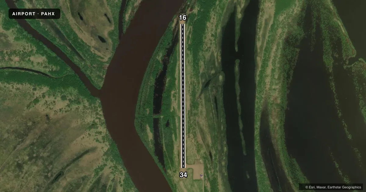
Runways & pattern
Full pagePattern entry · RWY 16
LEFT TRAFFICRunway end performance
| End | TORA | TODA | ASDA | LDA | VGSI | Approach lights | Obstruction |
|---|---|---|---|---|---|---|---|
| 16 | — | — | — | — | — | — | 38', trees, 0' from thr, 180' R of cntrln, slope 0 |
| 34 | — | — | — | — | PAPI 4-box left(3°) | — | 20', brush, 0' from thr, 217' R of cntrln, slope 0 |
Declared distances in feet. TORA = takeoff run available, TODA = takeoff distance, ASDA = accelerate-stop, LDA = landing distance.
Airport sketch
Runways drawn to scale from FAA survey coordinates, rendered over satellite imagery. Not for navigation.
Approaches & charts
Services on the field
Fuel grades, oxygen, maintenance, ramp storage and lighting — as declared to the FAA by the airport operator.
Fuel & services
- Fuel
- Not available
Ramp & ground
- Transient storage
- Not published
- Landing fee
- No fee published
- Customs
- Not available
- Lighting schedule
- SEE RMK
- Beacon schedule
- SS-SR
- Beacon
- White / Green (civil land)(WG)
- Wind indicator
- Lighted
- Segmented circle
- Yes
Fuel & FBOs
Cheapest 100LL and Jet A on the field and nearby. Always confirm with the FBO before taxi.
Airport notes
Surface conditions, obstructions, local procedures, lighting outages and other notes published with each FAA cycle.
General notes
- SPB OPS IN INNOKO RIVER ADJ TO VILLAGE.
- FLOODS DURG BREAKUP; SOFT AFT HVY RAIN.
- RWY COND UNMNT; RCMD VISUAL INSP BFR LNDG.
- WX CAMERA AVBL ON INTERNET AT HTTPS://WEATHERCAMS.FAA.GOV
Lighting notes
- ACTVT REIL RWY 34; PAPI RWY 34; MIRL RWY 16/34- CTAF.
Other notes
- THIS AIRPORT HAS BEEN SURVEYED BY THE NATIONAL GEODETIC SURVEY.
- ESTABD PRIOR TO 1959.
VFR map & nearby airports
VFR sectional. Tap any ICAO chip to open that airport.
Key facts · PAHX
Answer card- ICAO
- PAHX
- Name
- SHAGELUK
- Location
- SHAGELUK, ALASKA
- Elevation
- 78.6 ft MSL
- Traffic pattern altitude
- 1,078.6 ft MSL (1,000 AGL)
- Control tower
- Non-towered (use CTAF)
- Total runways
- 1
- Longest runway
- 16/34 · 3,400 ft
- Published ILS approaches
- 0
- Published frequencies
- 2
- Magnetic variation
- 15°
- Current flight rules
- VFR
- Current wind
- 240° at 8 kt
- Favored runway now
- RWY 16
Shageluk Airport sits in Shageluk, Alaska. Field elevation is 78.6 ft MSL. The airport has one runway. Runway 16/34 is 3,400 ft long with a gravel-dirt surface. No tower is published here. CTAF and UNICOM are both 122.8.
No ILS approaches are published for PAHX. Pattern altitude is not published in the facts, so use the standard 1,000 ft AGL for light piston traffic unless the current Chart Supplement says otherwise. The runway lighting notes matter here. Runway 34 has an end identifier light and a PAPI. Runways 16 and 34 have medium intensity runway lights. The field also has a published note that runway condition is unmonitored. Plan a visual inspection before landing.
This airport is in a remote Alaska setting. Flooding can happen during breakup. The surface can be soft after heavy rain. Seaplane base operations also occur in the Innoko River next to the village. There are no on-field FBOs listed, so contact the airport operator directly before arrival if you need local support or fuel details. For a first-time arrival, treat this as a short-field, surface-condition-sensitive stop and verify the latest field status before you launch.