METAR & TAF PACH
PACH does not publish a METAR.
Showing the nearest reporting station: PANI (ANIAK) · 9.4 NM away. Conditions at PACH may differ.
METAR · PANI
Observed 03:56Z
PANI 280356Z AUTO 22008KT 9SM BKN033 OVC041 13/08 A2999 RMK AO2 SLP156 T01280083 $
- Wind
- 220° @ 8 kt
- Visibility
- 9 SM
- Temp / Dew
- 13°C / 8°C
- Altimeter
- 29.99 inHg
- Clouds
- OVC
- Density alt
- -25 ft
- Ceiling
- 3,300 ft AGL
- Rules
- VFR
Airport info & contacts
Manager on record, flight service, ARTCC, attendance schedule and pattern altitude — published by the FAA and refreshed every 28 days.
Location
- From city
- 1 NM NE
- VFR sectional
- MC GRATH
- ARTCC
- ZAN · ANCHORAGE
- NOTAM facility
- ENA (NOTAM-D)
Airport manager
- Name
- KEN SMITH
- Phone
- 907-676-0505
- Address
- PO BOX 196900, ANCHORAGE AK 99519
Flight service · Hours
- FSS ENA
- KENAI907-283-72111-866-864-1737
- Attendance
- Unattended
Frequencies
Tap any row to copy the frequency to your clipboard.
Runways & pattern
Full pagePattern entry · RWY 27
LEFT TRAFFICRunway end performance
| End | TORA | TODA | ASDA | LDA | VGSI | Approach lights | Obstruction |
|---|---|---|---|---|---|---|---|
| 09 | — | — | — | — | PAPI 4-box left(3°) | — | 2', berm, 10' from thr, 67' R of cntrln, slope 5 |
| 27 | — | — | — | — | PAPI 4-box left(4°) | — | 3', brush, 15' from thr, 90' R of cntrln, slope 5 |
Declared distances in feet. TORA = takeoff run available, TODA = takeoff distance, ASDA = accelerate-stop, LDA = landing distance.
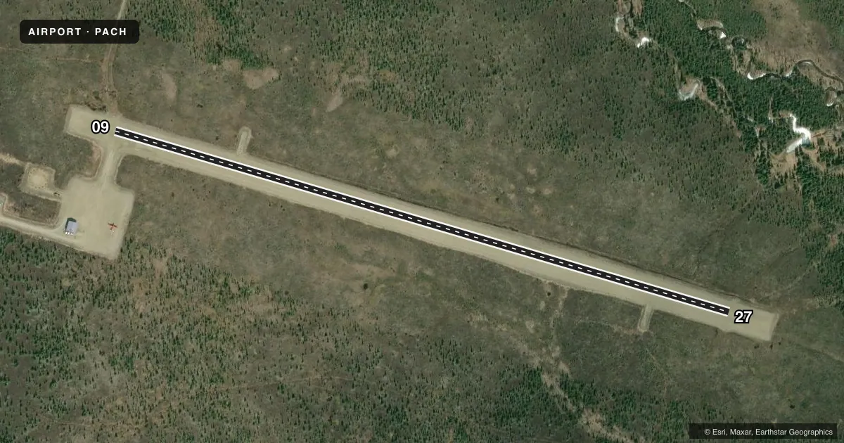
Airport sketch
Runways drawn to scale from FAA survey coordinates, rendered over satellite imagery. Not for navigation.
Approaches & charts
Services on the field
Fuel grades, oxygen, maintenance, ramp storage and lighting — as declared to the FAA by the airport operator.
Fuel & services
- Fuel
- Not available
Ramp & ground
- Transient storage
- Not published
- Lighting schedule
- SEE RMK
- Beacon schedule
- SEE RMK
- Beacon
- White / Green (civil land)(WG)
- Wind indicator
- Lighted
- Segmented circle
- Yes
Fuel & FBOs
Cheapest 100LL and Jet A on the field and nearby. Always confirm with the FBO before taxi.
Airport notes
Surface conditions, obstructions, local procedures, lighting outages and other notes published with each FAA cycle.
General notes
- RWY COND UNMNT; RCMD VISUAL INSP BFR USE.
- COLD TEMPERATURE AIRPORT. ALTITUDE CORRECTION REQUIRED AT OR BELOW -31C.
Lighting notes
- ACTVT ROTG BCN - CTAF.
- ACTVT REIL RWY 09 & 27; PAPI RWY 09 & 27; MIRL RWY 09/27 - CTAF.
Other notes
- THIS AIRPORT HAS BEEN SURVEYED BY THE NATIONAL GEODETIC SURVEY.
- 09/27FROST HEAVES & SINK HOLES RWY ENDS & RAMP.
VFR map & nearby airports
VFR sectional. Tap any ICAO chip to open that airport.
Key facts · PACH
Answer card- ICAO
- PACH
- Name
- CHUATHBALUK
- Location
- CHUATHBALUK, ALASKA
- Elevation
- 243.7 ft MSL
- Traffic pattern altitude
- 1,243.7 ft MSL (1,000 AGL)
- Control tower
- Non-towered (use CTAF)
- Total runways
- 1
- Longest runway
- 09/27 · 3,401 ft
- Published ILS approaches
- 0
- Published frequencies
- 1
- Magnetic variation
- 15°
- Current flight rules
- VFR
- Current wind
- 220° at 8 kt
- Favored runway now
- RWY 27
Chuathbaluk Airport (PACH) sits in Chuathbaluk, Alaska. Field elevation is 243.7 ft MSL. The airport has one runway. Runway 09/27 is 3,401 ft long with a gravel-dirt surface. There is no control tower. CTAF is 122.9. No ILS approaches are published.
Pattern altitude is not published. Use 1,000 ft AGL as the standard light piston pattern unless local procedures or current Chart Supplement guidance say otherwise. The runway headings are magnetic 106° and 286°. The field has a rotating beacon that is activated by CTAF. Runway end identifier lights, PAPI and medium intensity runway lights are installed on 09/27. They are controlled by CTAF.
There are no on-field FBOs listed. Plan to arrive self-sufficient. Published remarks also call out cold temperature operations. Altitude correction is required at or below minus 31 degrees Celsius. Runway condition is unmonitored. A visual check before use is a good idea. Frost heaves and sink holes are reported at the runway ends and ramp, so taxi and landing roll need extra attention.