METAR & TAF PANI
Current METAR
Observed 08:56Z
PANI 280856Z AUTO 25009KT 10SM OVC038 10/07 A3004 RMK AO2 SLP175 T01000072 52012 $
- Wind
- 250° @ 9 kt
- Visibility
- 10 SM
- Temp / Dew
- 10°C / 7°C
- Altimeter
- 30.04 inHg
- Clouds
- OVC
- Density alt
- -629 ft
- Ceiling
- 3,800 ft AGL
- Rules
- VFR
Airport info & contacts
Manager on record, flight service, ARTCC, attendance schedule and pattern altitude — published by the FAA and refreshed every 28 days.
Location
- From city
- 0 NM S
- VFR sectional
- MC GRATH
- ARTCC
- ZAN · ANCHORAGE
- NOTAM facility
- ANI (NOTAM-D)
Airport manager
- Name
- KEN SMITH
- Phone
- 907-676-0505
- Address
- PO BOX 196900, ANIAK AIRPORT, ANCHORAGE AK 99519
Flight service · Hours
- FSS ENA
- KENAI907-283-72111-866-864-1737
- Attendance
- 1 MAY- 14 OCT · MON- FRI · 0730L-1630L
- 15 OCT- 30 APR · SUN-SAT · 0730L-1630L
Frequencies
Tap any row to copy the frequency to your clipboard.
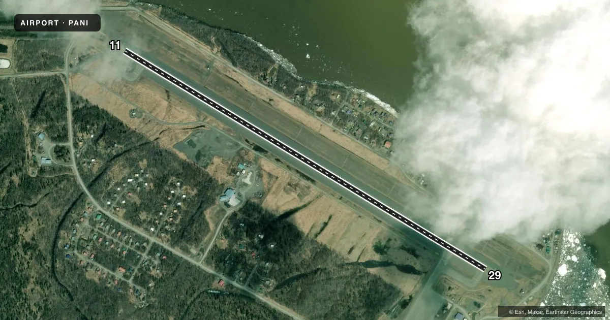
Runways & pattern
Full pagePattern entry · RWY 29
LEFT TRAFFICRunway end performance
| End | TORA | TODA | ASDA | LDA | VGSI | Approach lights | Obstruction |
|---|---|---|---|---|---|---|---|
| 11 | 5,800' | 6,200' | 5,800' | 5,400' | PAPI 4-box right(3°) | MALSF | 7', road, 364' from thr, 525' R of cntrln, slope 23 |
| 29 | 5,800' | 6,200' | 5,800' | 5,400' | PAPI 4-box right(3°) | — | 30', pole, 310' from thr, 513' R of cntrln, slope 3 |
Declared distances in feet. TORA = takeoff run available, TODA = takeoff distance, ASDA = accelerate-stop, LDA = landing distance.
Airport sketch
Runways drawn to scale from FAA survey coordinates, rendered over satellite imagery. Not for navigation.
Approaches & charts
ILS · 1
Services on the field
Fuel grades, oxygen, maintenance, ramp storage and lighting — as declared to the FAA by the airport operator.
Fuel & services
- Fuel
- 100LLA
- Airframe repair
- Minor
- Power plant repair
- Minor
- Other services
- CARGO
Ramp & ground
- Transient storage
- Tie-down
- Landing fee
- No fee published
- Lighting schedule
- SEE RMK
- Beacon schedule
- SS-SR
- Beacon
- White / Green (civil land)(WG)
- Wind indicator
- Lighted
- Segmented circle
- Yes
Fuel & FBOs
Cheapest 100LL and Jet A on the field and nearby. Always confirm with the FBO before taxi.
Airport notes
Surface conditions, obstructions, local procedures, lighting outages and other notes published with each FAA cycle.
General notes
- PAEW ON THE RWY.
- TSNT PRKG AVBL, MRKD WITH GREEN CONES.
- WX CAMERA AVBL ON INTERNET AT HTTPS://WEATHERCAMS.FAA.GOV/.
- COLD TEMPERATURE AIRPORT. ALTITUDE CORRECTION REQUIRED AT OR BELOW -37C.
- LOCK WHEEL TURNS NA ALL SFCS.
- FUEL TRUCK ACES AVBL SLOUGH BEACH E OF RAMP.
- ARPT SAND LRGR GRADATION THAN FAA RCMDD/SEE AC150/5200-30.
Lighting notes
- ACTVT MALSF RWY 11; PAPI RWY 11 & 29; HIRL RWY 11/29 - CTAF.
Fuel notes
- 100LLFUEL AVBL - CTAF OR 907-675-4295.
Runway surface & condition
- 11/29PCR VALUE: 405/F/A/X/T
VFR map & nearby airports
VFR sectional. Tap any ICAO chip to open that airport.
Key facts · PANI
Answer card- ICAO
- PANI
- Name
- ANIAK
- Location
- ANIAK, ALASKA
- Elevation
- 96.8 ft MSL
- Traffic pattern altitude
- 1,096.8 ft MSL (1,000 AGL)
- Control tower
- Non-towered (use CTAF)
- Total runways
- 1
- Longest runway
- 11/29 · 6,200 ft
- Published ILS approaches
- 1
- Published frequencies
- 1
- Magnetic variation
- 12°
- Current flight rules
- VFR
- Current wind
- 250° at 9 kt
- Favored runway now
- RWY 29
Aniak Airport sits in Aniak, Alaska. Field elevation is 96.8 ft MSL. The airport has one runway. Runway 11/29 is 6,200 ft asphalt with magnetic headings of 121° and 301°. There is no control tower. CTAF is 122.1.
One ILS approach is published for runway 11. The field also has PAPI on runways 11 and 29. High intensity runway lights are available on both ends. The FAA remarks note a malfunctioning approach lighting system on runway 11. Plan that into your arrival. Verify current lighting status before you go. Pattern altitude is not published. Use standard 1,000 ft AGL for light piston traffic unless the current FAA Chart Supplement says otherwise.
On the field, Artic Trans Service and Crowley Aviation Fuels are listed. Crowley Aviation Fuels carries AVGAS 100LL and Jet A. Artic Trans Service lists fuel access by phone. Fuel truck access is available at Slough Beach east of the ramp. Transient parking is marked with green cones. This is a cold temperature airport. Altitude correction is required at or below minus 37 degrees Celsius. The airport also notes positive aircraft exit warning on the runway. For a first-time arrival, verify current lighting, cold weather performance and surface condition before you launch.