METAR & TAF PARS
Current METAR
Observed 04:56Z
PARS 280456Z AUTO 21007KT 10SM OVC049 13/09 A2999 RMK AO2 SLP158 T01280089 $
- Wind
- 210° @ 7 kt
- Visibility
- 10 SM
- Temp / Dew
- 13°C / 9°C
- Altimeter
- 29.99 inHg
- Clouds
- OVC
- Density alt
- -255 ft
- Ceiling
- 4,900 ft AGL
- Rules
- VFR
Airport info & contacts
Manager on record, flight service, ARTCC, attendance schedule and pattern altitude — published by the FAA and refreshed every 28 days.
Location
- From city
- 0 NM SE
- VFR sectional
- MC GRATH
- ARTCC
- ZAN · ANCHORAGE
- NOTAM facility
- RSH (NOTAM-D)
Airport manager
- Name
- ERIK WEINGARTH
- Phone
- 907-438-2416
- Address
- PO BOX 135, ST MARYS AK 99658
Flight service · Hours
- FSS ENA
- KENAI907-283-72111-866-864-1737
- Attendance
- Unattended
Frequencies
Tap any row to copy the frequency to your clipboard.
Runways & pattern
Full pagePattern entry · RWY 18
LEFT TRAFFICRunway end performance
| End | TORA | TODA | ASDA | LDA | VGSI | Approach lights | Obstruction |
|---|---|---|---|---|---|---|---|
| 18 | — | — | — | — | — | — | 26', trees, 0' from thr, 230' R of cntrln, slope 0 |
| 36 | — | — | — | — | PAPI 4-box left(4.25°) | — | 30', trees, 0' from thr, 240' R of cntrln, slope 0 |
Declared distances in feet. TORA = takeoff run available, TODA = takeoff distance, ASDA = accelerate-stop, LDA = landing distance.
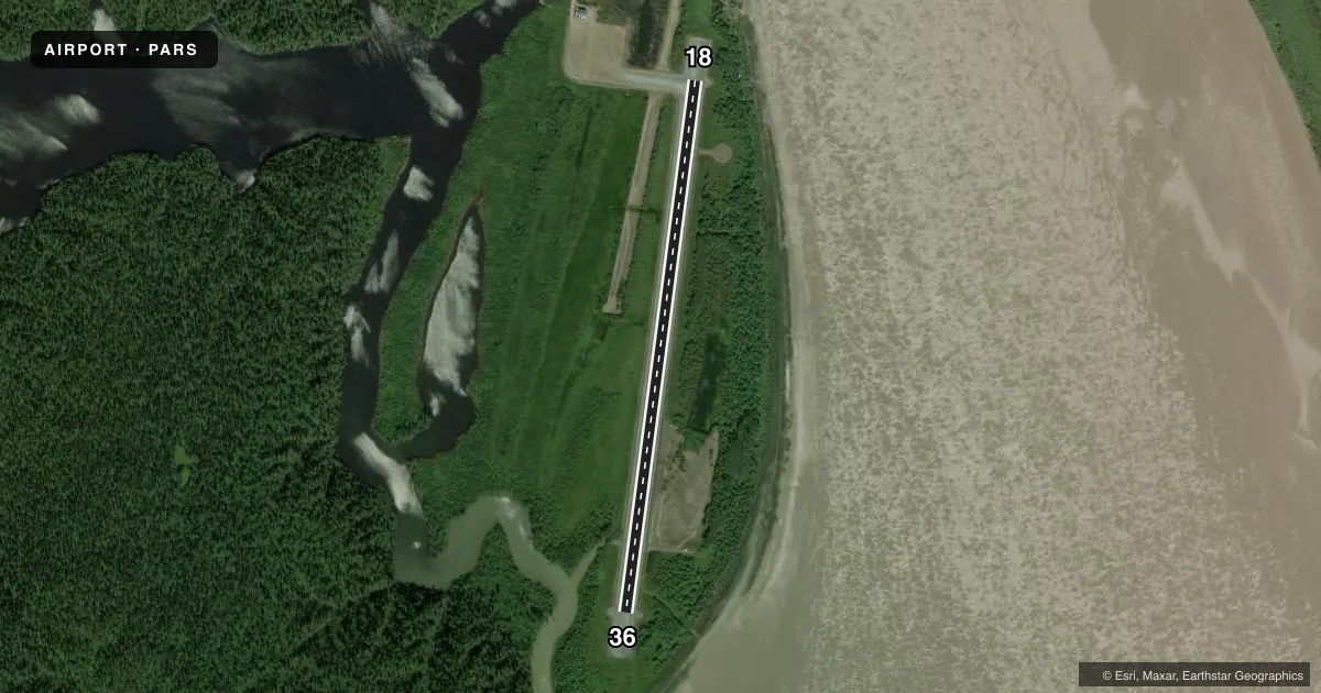
Airport sketch
Runways drawn to scale from FAA survey coordinates, rendered over satellite imagery. Not for navigation.
Approaches & charts
Services on the field
Fuel grades, oxygen, maintenance, ramp storage and lighting — as declared to the FAA by the airport operator.
Fuel & services
- Fuel
- Not available
- Oxygen (bottled)
- Not available
- Oxygen (bulk)
- Not available
- Airframe repair
- Not available
- Power plant repair
- Not available
Ramp & ground
- Transient storage
- Tie-down
- Landing fee
- No fee published
- Customs
- Not available
- Lighting schedule
- SEE RMK
- Beacon schedule
- SEE RMK
- Beacon
- White / Green (civil land)(WG)
- Wind indicator
- Lighted
- Segmented circle
- Yes
Fuel & FBOs
Cheapest 100LL and Jet A on the field and nearby. Always confirm with the FBO before taxi.
Airport notes
Surface conditions, obstructions, local procedures, lighting outages and other notes published with each FAA cycle.
General notes
- SEAPLANES OPERATE N-S IN YUKON RIVER AND E-W IN NUNVOTCHUK LAKE. WATCH FOR FISH NETS CLOSE TO SHORE.
- RWY CONDITION NOT MONITORED - RECOMMEND VISUAL INSPECTION PRIOR TO LNDG.
- WX CAMERA AVBL ON INTERNET AT HTTPS://WEATHERCAMS.FAA.GOV
- COLD TEMPERATURE AIRPORT. ALTITUDE CORRECTION REQUIRED AT OR BELOW -30C.
Lighting notes
- ACTVT ROTG BCN - CTAF.
- ACTVT REIL RWY 18 & 36; PAPI RWY 36; MIRL RWY 18/36; WINDSOCK - CTAF.
Approach & departure obstructions
- 36PAPI UNUSBL BYD 9 DEGS RIGHT OF CNTRLN.
VFR map & nearby airports
VFR sectional. Tap any ICAO chip to open that airport.
Key facts · PARS
Answer card- ICAO
- PARS
- Name
- RUSSIAN MISSION
- Location
- RUSSIAN MISSION, ALASKA
- Elevation
- 58.3 ft MSL
- Traffic pattern altitude
- 1,058.3 ft MSL (1,000 AGL)
- Control tower
- Non-towered (use CTAF)
- Total runways
- 1
- Longest runway
- 18/36 · 3,620 ft
- Published ILS approaches
- 0
- Published frequencies
- 1
- Magnetic variation
- 11°
- Current flight rules
- VFR
- Current wind
- 210° at 7 kt
- Favored runway now
- RWY 18
Russian Mission Airport (PARS) sits in Russian Mission, Alaska near the Yukon River. Field elevation is 58.3 ft MSL. The airport has one runway. Runway 18/36 is 3,620 ft of gravel and is the longest runway on the field. There is no control tower. CTAF is 122.9. No ILS approaches are published here. The published pattern altitude is not listed, so use the current Chart Supplement and local traffic calls before you arrive.
There are no on-field FBOs listed. Plan on self-briefing the field and confirming services before departure. Published remarks say runway condition is not monitored, so a visual inspection before landing is a good idea. The rotating beacon, windsock, runway end identifier lights and the medium intensity runway lights are activated by CTAF. Runway 36 has a PAPI. It is unusable beyond 9 degrees right of centerline. That matters if you are lining up in gusty or crosswind conditions.
This is a cold temperature airport. Altitude correction is required at or below minus 30 degrees Celsius. Seaplane traffic also operates nearby on the Yukon River and Nunvotchuk Lake. Watch for fish nets close to shore. Check the current Chart Supplement for any published noise or curfew restrictions before flying into the field.