METAR & TAF PFZK
Current METAR
Observed 02:56Z
PFZK 280256Z AUTO 22014KT 10SM SCT022 OVC039 12/07 A3001 RMK AO2 SLP160 60000 T01220072 51004 $
- Wind
- 220° @ 14 kt
- Visibility
- 10 SM
- Temp / Dew
- 12°C / 7°C
- Altimeter
- 30.01 inHg
- Clouds
- OVC
- Density alt
- -443 ft
- Ceiling
- 3,900 ft AGL
- Rules
- VFR
Airport info & contacts
Manager on record, flight service, ARTCC, attendance schedule and pattern altitude — published by the FAA and refreshed every 28 days.
Location
- From city
- 2 NM W
- VFR sectional
- MC GRATH
- ARTCC
- ZAN · ANCHORAGE
- NOTAM facility
- ENA (NOTAM-D)
Airport manager
- Name
- JOSEPH LARAUX
- Phone
- 907-543-2498
- Address
- STATE OF ALASKA DOT, 2016 AIRPORT ROAD, BETHEL AK 99559
Flight service · Hours
- FSS ENA
- KENAI907-283-72111-866-864-1737
- Attendance
- Unattended
Frequencies
Tap any row to copy the frequency to your clipboard.
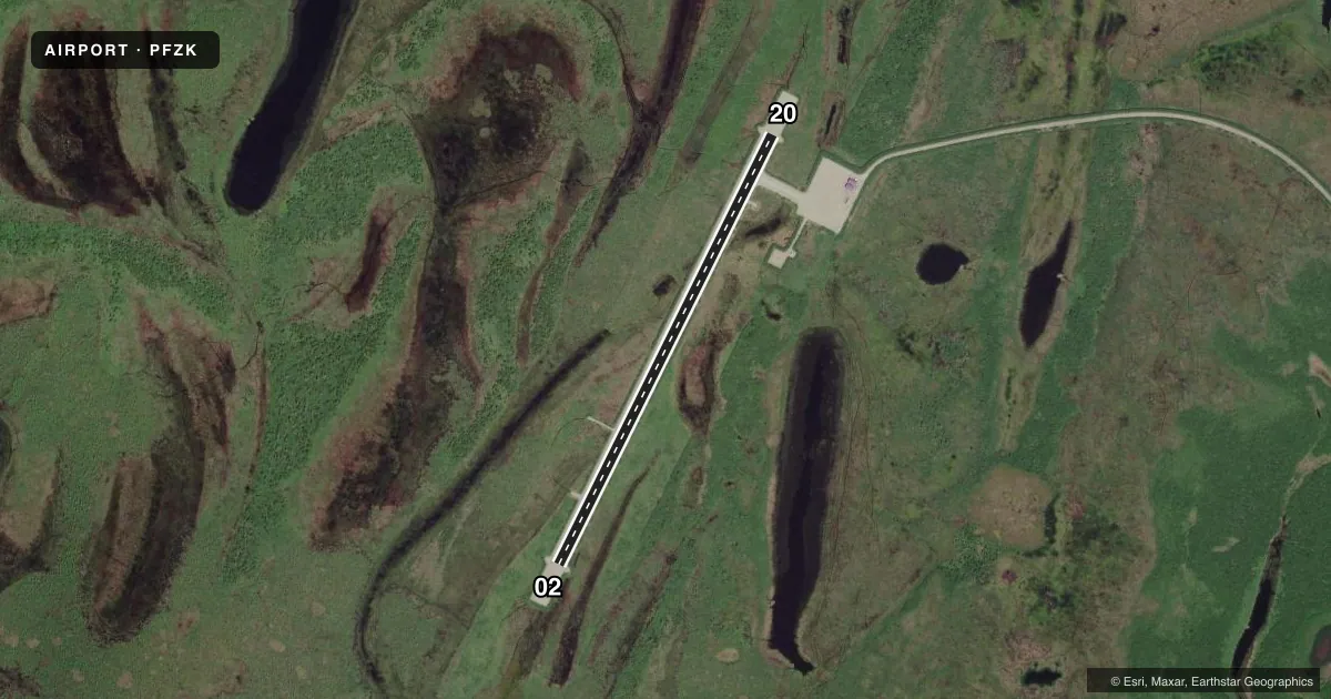
Runways & pattern
Full pagePattern entry · RWY 20
LEFT TRAFFICAirport sketch
Runways drawn to scale from FAA survey coordinates, rendered over satellite imagery. Not for navigation.
Approaches & charts
Services on the field
Fuel grades, oxygen, maintenance, ramp storage and lighting — as declared to the FAA by the airport operator.
Fuel & services
- Fuel
- Not available
Ramp & ground
- Transient storage
- Not published
- Landing fee
- No fee published
- Customs
- Not available
- Lighting schedule
- SEE RMK
- Beacon schedule
- SEE RMK
- Beacon
- White / Green (civil land)(WG)
- Wind indicator
- Lighted
- Segmented circle
- Yes
Fuel & FBOs
Cheapest 100LL and Jet A on the field and nearby. Always confirm with the FBO before taxi.
Airport notes
Surface conditions, obstructions, local procedures, lighting outages and other notes published with each FAA cycle.
General notes
- RWY COND UNMNT; RCMD VISUAL INSP PRIOR TO USE.
- WX CAMERA AVBL ON INTERNET AT HTTPS://WEATHERCAMS.FAA.GOV
Lighting notes
- ACTVT ROTG BCN - CTAF.
- ACTVT MIRL RWY 02/20; WINDSOCK - CTAF.
Runway surface & condition
- 02/20HEAVES & DIPS FULL LEN.
Approach & departure obstructions
- 02LGTS, REFLECTIVE CONES & THR MKD.
- 20LGTS, REFLECTIVE CONES & THR MKD.
VFR map & nearby airports
VFR sectional. Tap any ICAO chip to open that airport.
Key facts · PFZK
Answer card- ICAO
- PFZK
- Name
- AKIACHAK
- Location
- AKIACHAK, ALASKA
- Elevation
- 22.8 ft MSL
- Traffic pattern altitude
- 1,022.8 ft MSL (1,000 AGL)
- Control tower
- Non-towered (use CTAF)
- Total runways
- 1
- Longest runway
- 02/20 · 3,300 ft
- Published ILS approaches
- 0
- Published frequencies
- 1
- Magnetic variation
- 8°
- Current flight rules
- VFR
- Current wind
- 220° at 14 kt
- Favored runway now
- RWY 20
Akiachak Airport sits in Akiachak, Alaska. Field elevation is 22.8 ft MSL. The airport has one runway. Runway 02/20 is 3,300 ft long and gravel. There is no control tower. CTAF is 122.9.
No ILS approaches are published here. Pattern altitude is not published, so use standard 1,000 ft AGL for light piston operations unless the current Chart Supplement says otherwise. The published remarks matter here. Runway lights, reflective cones and the threshold are marked on both ends. The rotating beacon is activated on CTAF. Medium intensity runway lights are available for runway 02/20. The windsock is on CTAF too.
Plan for a rough-field check before landing. Runway condition is unmonitored. A visual inspection is recommended before use. Heaves and dips are present along the full length of the runway. That makes a careful arrival and departure briefing important, especially if you are new to gravel or operating with a heavier load. No on-field FBOs are listed. Verify services with the airport operator or call the field directly before you go.