METAR & TAF PABE
Current METAR
Observed 12:36Z
PABE 281236Z 17007KT 10SM BKN029 OVC037 08/07 A3006 RMK AO2 T00830067
- Wind
- 170° @ 7 kt
- Visibility
- 10 SM
- Temp / Dew
- 8°C / 7°C
- Altimeter
- 30.06 inHg
- Clouds
- OVC
- Density alt
- -854 ft
- Ceiling
- 2,900 ft AGL
- Rules
- MVFR
Airport info & contacts
Manager on record, flight service, ARTCC, attendance schedule and pattern altitude — published by the FAA and refreshed every 28 days.
Location
- From city
- 3 NM SW
- VFR sectional
- MC GRATH
- ARTCC
- ZAN · ANCHORAGE
- NOTAM facility
- BET (NOTAM-D)
Airport manager
- Name
- NICK NORWOOD
- Phone
- 907-543-2498
- Address
- BOX 505, BETHEL AK 99559
Flight service · Hours
- FSS ENA
- KENAI907-283-72111-866-864-1737
- Attendance
- MAY-OCT · MON-FRI · 0700-2100
- MAY-OCT · SAT-SUN · 0700-2200
- NOV-APR · MON-FRI · 0500-2100
- NOV-APR · SAT-SUN · 0700-2100
Frequencies
Tap any row to copy the frequency to your clipboard.
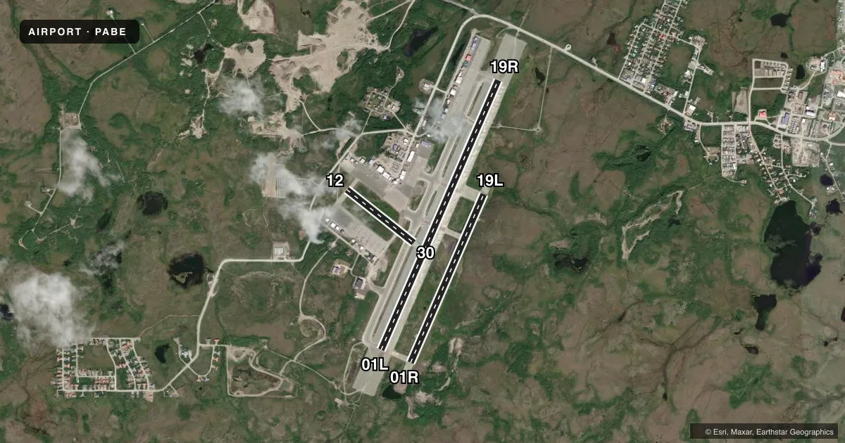
Runways & pattern
Full pagePattern entry · RWY 19R
LEFT TRAFFIC| Runway | Heading (°M) | Length | Surface | Traffic |
|---|---|---|---|---|
| 01L/19RFavored | 12° / 192° | 6,400 ft | ASPH | Standard L |
| 01R/19L | 12° / 192° | 4,000 ft | ASPH | Standard L |
| 12/30 | 117° / 297° | 1,858 ft | GRVL | Standard L |
Runway end performance
| End | TORA | TODA | ASDA | LDA | VGSI | Approach lights | Obstruction |
|---|---|---|---|---|---|---|---|
| 01L | 6,400' | 6,400' | 6,400' | 6,400' | VASI 4-box left(3°) | MALSR | — |
| 19R | 6,400' | 6,400' | 6,400' | 6,400' | VASI 4-box left(3°) | MALSR | — |
| 01R | — | — | — | — | PAPI 4-box left(3°) | — | — |
| 19L | — | — | — | — | PAPI 4-box left(3°) | — | — |
Declared distances in feet. TORA = takeoff run available, TODA = takeoff distance, ASDA = accelerate-stop, LDA = landing distance.
Airport sketch
Runways drawn to scale from FAA survey coordinates, rendered over satellite imagery. Not for navigation.
Approaches & charts
ILS · 1
Services on the field
Fuel grades, oxygen, maintenance, ramp storage and lighting — as declared to the FAA by the airport operator.
Fuel & services
- Fuel
- 100100LLAA1
- Airframe repair
- Minor
- Power plant repair
- Minor
- Other services
- CARGO
Ramp & ground
- Transient storage
- Tie-down
- Hangar
- Lighting schedule
- SEE RMK
- Beacon schedule
- SS-SR
- Beacon
- White / Green (civil land)(WG)
- Wind indicator
- Lighted
- Segmented circle
- Yes
Fuel & FBOs
Cheapest 100LL and Jet A on the field and nearby. Always confirm with the FBO before taxi.
Airport notes
Surface conditions, obstructions, local procedures, lighting outages and other notes published with each FAA cycle.
General notes
- PAEW MAY BE ON RWYS.
- PTARMIGAN & WATERFOWL INVOF ARPT.
- WX CAMERA AVBL ON INTERNET AT HTTPS://WEATHERCAMS.FAA.GOV.
- TSNT PRKG W END OF S RAMP MRKD BY GREEN CONES.
- COND RPRTG & OTR MAINT SVC AVBL DURG MAINT DUTY HR. AFT HR SVC PPR IN WRITING - AMGR.
- NWS BLN LAUNCH FAC ON ARPT - SEE INSIDE BACK CVR FOR OPS DTLS.
- LOCK WHEEL TURNS NA ALL SFCS.
- TSA REG; SEE 49 CFR 1542. GATES & DOORS SECURED ALL TIMES. UNFAM TSNT - AMGR.
- ARPT SAND SMALLER GRADATION THAN FAA RCMDD/SEE AC150/5200-30.
Lighting notes
- WHEN ATCT CLSD ACTVT HIRL RWY 01L/19R, 01R/19L, RWY 12/30; TWY LIGHTS - CTAF. ACTVT MALSR RWY 01L & 19R; REIL RWY 01R & 19L; VASI RWY 01L & 19R; PAPI RWY 01R & 19L - CTAF.
Fuel notes
- 100SELF VC FUEL NA; FEE AFT 1800.
Runway surface & condition
- 01L/19RPCR VALUE: 514/F/C/X/T
- 01R/19LPCR VALUE: 361/F/C/X/T
- 01R/19LRWY 01R/19L NOT AVBL FOR PART 121/380 SKED AND NON-SKED OPS WITH PAX CARRYING OPS MORE THAN 30 PAX SEATS.
- 12/30RWY 12/30 NOT AVBL FOR PART 121/PART 380 OPS WITH SKED PAX CARRYING OPS MORE THAN 9 PAX SEATS AND NON-SKED PAX CARRYING OPS MORE THAN 30 PAX SEATS. W 1200 FT CLSD OVR 12500 LBS GWT APR-NOV.
Approach & departure obstructions
- 01LTOUCHDOWN RVR AVBL 0700-2000 1 NOV-30 MAR; 1 APR-31 OCT 0700-2200.
- 19RTOUCHDOWN RVR AVBL 0700-2000 1 NOV-30 MAR; 1 APR-31 OCT 0700-2200.
Other notes
- CLSD TO ACR OPS MORE THAN 30 PAX SEATS OR APVD WRITTEN PPR - AMGR BOX 505, BETHEL, AK 99559.
- 12/30495 FT ASPH RWY 30 END; RMNG GRVL.
VFR map & nearby airports
VFR sectional. Tap any ICAO chip to open that airport.
Key facts · PABE
Answer card- ICAO
- PABE
- Name
- BETHEL
- Location
- BETHEL, ALASKA
- Elevation
- 128.8 ft MSL
- Traffic pattern altitude
- 1,128.8 ft MSL (1,000 AGL)
- Control tower
- Towered · 0700-2200 1 APR - 31 OCT; 0700-2000 1 NOV - 31 MAR.
- Total runways
- 3
- Longest runway
- 01L/19R · 6,400 ft
- Published ILS approaches
- 1
- Published frequencies
- 5
- Magnetic variation
- 11°
- Current flight rules
- MVFR
- Current wind
- 170° at 7 kt
- Favored runway now
- RWY 19R
Bethel Airport sits in Bethel, Alaska at 128.8 ft MSL. It has three runways. The longest is 01L/19R at 6,400 ft. The tower is open 0700-2200 from 1 April to 31 October. It is open 0700-2000 from 1 November to 31 March. One ILS is published. It serves runway 19R. Pattern altitude is not published. Use 1,000 ft AGL for light piston traffic unless ATC or the current Chart Supplement says otherwise.
The field is busy enough that the published remarks matter. Bethel is TSA regulated. Gates and doors are secured at all times. Unfamiliar transient aircraft should contact the airport manager. Weather cameras are available online for a quick look before departure or arrival. Runway lighting can be activated by CTAF when the tower is closed. That includes the high intensity runway lights, taxiway lights, ALSF-style approach lighting, REILs, VASI and PAPI as published for the runway ends.
Delta Western is on the field. It carries 100LL, Jet A and Jet A Prist. Crowley Aviation Fuels is also on the field. It carries 100LL and Jet A. Runway 12/30 has a gravel surface with 495 ft of asphalt on the 30 end. Runway 01R/19L has a published PCN and is not available for certain large scheduled passenger operations. For any current noise, access, or operational limits, check the current FAA Chart Supplement or call the airport operator before you go.