METAR & TAF PAPK
PAPK does not publish a METAR.
Showing the nearest reporting station: PABE (BETHEL) · 4.9 NM away. Conditions at PAPK may differ.
METAR · PABE
Observed 12:36Z
PABE 281236Z 17007KT 10SM BKN029 OVC037 08/07 A3006 RMK AO2 T00830067
- Wind
- 170° @ 7 kt
- Visibility
- 10 SM
- Temp / Dew
- 8°C / 7°C
- Altimeter
- 30.06 inHg
- Clouds
- OVC
- Density alt
- -999 ft
- Ceiling
- 2,900 ft AGL
- Rules
- MVFR
Airport info & contacts
Manager on record, flight service, ARTCC, attendance schedule and pattern altitude — published by the FAA and refreshed every 28 days.
Location
- From city
- 1 NM SW
- VFR sectional
- BETHEL
- ARTCC
- ZAN · ANCHORAGE
- NOTAM facility
- ENA (NOTAM-D)
Airport manager
- Name
- JOSEPH LARAUX
- Phone
- (907) 543-2498
- Address
- BOX 505, BETHEL AK 99559
Flight service · Hours
- FSS ENA
- KENAI907-283-72111-866-864-1737
- Attendance
- Unattended
Frequencies
Tap any row to copy the frequency to your clipboard.
Runways & pattern
Full pagePattern entry · RWY 20
LEFT TRAFFICRunway end performance
| End | TORA | TODA | ASDA | LDA | VGSI | Approach lights | Obstruction |
|---|---|---|---|---|---|---|---|
| 02 | — | — | — | — | — | — | 18', brush, 0' from thr, 85' R of cntrln, slope 0 |
| 20 | — | — | — | — | — | — | 12', brush, 0' from thr, 110' R of cntrln, slope 0 |
Declared distances in feet. TORA = takeoff run available, TODA = takeoff distance, ASDA = accelerate-stop, LDA = landing distance.
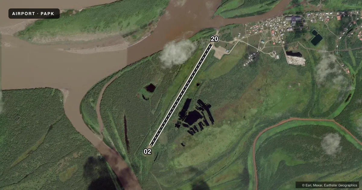
Airport sketch
Runways drawn to scale from FAA survey coordinates, rendered over satellite imagery. Not for navigation.
Approaches & charts
Services on the field
Fuel grades, oxygen, maintenance, ramp storage and lighting — as declared to the FAA by the airport operator.
Fuel & services
- Fuel
- Not available
- Oxygen (bottled)
- Not available
- Oxygen (bulk)
- Not available
- Airframe repair
- Not available
- Power plant repair
- Not available
Ramp & ground
- Transient storage
- Tie-down
- Landing fee
- No fee published
- Customs
- Not available
- Lighting schedule
- SEE RMK
- Beacon schedule
- SS-SR
- Beacon
- White / Green (civil land)(WG)
- Wind indicator
- Lighted
- Segmented circle
- Yes
Fuel & FBOs
Cheapest 100LL and Jet A on the field and nearby. Always confirm with the FBO before taxi.
Airport notes
Surface conditions, obstructions, local procedures, lighting outages and other notes published with each FAA cycle.
General notes
- CTN: AREA IN FRONT OF VILLAGE UNUSBL FOR FLOAT PLANE. SOFT MUDDY BEACH.BOATS & NETS IN RIVER. BARGES N END OF RWY; MACHINERY & SUPPLY OBSTNS IN AREA.
- RWY COND NOT MNT; RCMD VISUAL INSPN PRIOR TO USE.
- WX CAMERA AVBL ON INTERNET AT HTTPS://WEATHERCAMS.FAA.GOV
Lighting notes
- ACTVT MIRL RWY 02/20 - CTAF.
Runway surface & condition
- 02/20FLOODS IN SPRING.
Other notes
- SPB ASP: ESTABD PRIOR TO 1959.
- WINDSOCKS UNRELBL.
VFR map & nearby airports
VFR sectional. Tap any ICAO chip to open that airport.
Key facts · PAPK
Answer card- ICAO
- PAPK
- Name
- NAPASKIAK
- Location
- NAPASKIAK, ALASKA
- Elevation
- 11.4 ft MSL
- Traffic pattern altitude
- 1,011.4 ft MSL (1,000 AGL)
- Control tower
- Non-towered (use CTAF)
- Total runways
- 1
- Longest runway
- 02/20 · 3,000 ft
- Published ILS approaches
- 0
- Published frequencies
- 1
- Magnetic variation
- 15°
- Current flight rules
- MVFR
- Current wind
- 170° at 7 kt
- Favored runway now
- RWY 20
Napaskiak Airport sits in Napaskiak, Alaska. The field elevation is 11.4 ft MSL. It has one runway. Runway 02/20 is 3,000 ft long with a gravel surface. No tower is published here. CTAF is 122.9.
No ILS approaches are published. The pattern altitude is not published, so use the standard 1,000 ft AGL for light piston operations unless the current FAA Chart Supplement says otherwise. The runway headings in the facts are magnetic. Runway 02/20 is listed at 31°/211°.
There are no on-field FBOs listed. Check with the airport operator or the field on CTAF before arrival for current services. Published remarks say the runway condition is not maintained. A visual inspection before use is recommended. Windsocks are unreliable. Flooding occurs in spring. There are also barges at the north end of the runway. Machinery and supply obstructions are in the area. The village front has a soft muddy beach that is unusable for floatplanes. Medium intensity runway lights on 02/20 are activated by CTAF. For a first visit, plan for a rough-field check. Watch for river traffic and debris. Verify current conditions before committing.