METAR & TAF PANA
Current METAR
Observed 20:56Z
PANA 122056Z AUTO 07003KT 9SM SCT043 BKN055 OVC065 M13/M19 A3028 RMK AO2 SLP254 60000 T11331189 53000 FZRANO TSNO
- Wind
- 070° @ 3 kt
- Visibility
- 9 SM
- Temp / Dew
- -13°C / -19°C
- Altimeter
- 30.28 inHg
- Clouds
- OVC
- Density alt
- -3,785 ft
- Ceiling
- 5,500 ft AGL
- Rules
- VFR
Airport info & contacts
Manager on record, flight service, ARTCC, attendance schedule and pattern altitude — published by the FAA and refreshed every 28 days.
Location
- From city
- 0 NM W
- VFR sectional
- BETHEL
- ARTCC
- ZAN · ANCHORAGE
- NOTAM facility
- WNA (NOTAM-D)
Airport manager
- Name
- JOSEPH LARAUX
- Phone
- (907) 543-2498
- Address
- PO BOX 505, BETHEL AK 99559
Flight service · Hours
- FSS ENA
- KENAI907-283-72111-866-864-1737
- Attendance
- Unattended
Frequencies
Tap any row to copy the frequency to your clipboard.
Runways & pattern
Full pagePattern entry · RWY 34
LEFT TRAFFICRunway end performance
| End | TORA | TODA | ASDA | LDA | VGSI | Approach lights | Obstruction |
|---|---|---|---|---|---|---|---|
| 16 | — | — | — | — | PAPI 4-box left(3°) | — | 10', brush, 74' R of cntrln |
| 34 | — | — | — | — | PAPI 4-box left(3°) | — | 12', brush, 65' R of cntrln |
Declared distances in feet. TORA = takeoff run available, TODA = takeoff distance, ASDA = accelerate-stop, LDA = landing distance.
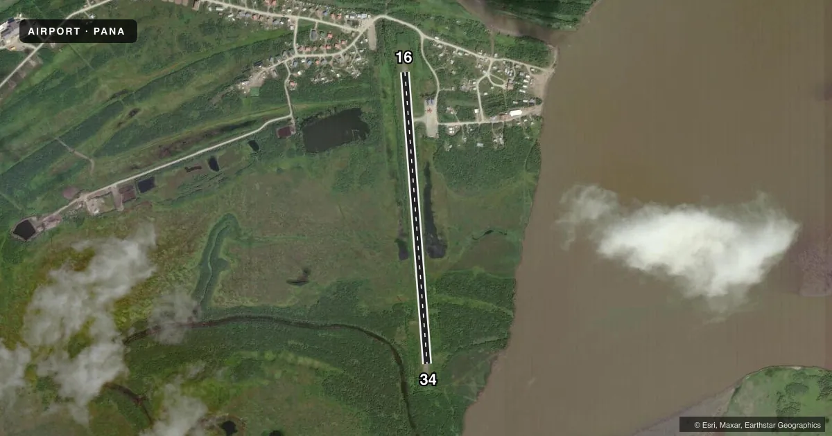
Airport sketch
Runways drawn to scale from FAA survey coordinates, rendered over satellite imagery. Not for navigation.
Approaches & charts
Services on the field
Fuel grades, oxygen, maintenance, ramp storage and lighting — as declared to the FAA by the airport operator.
Fuel & services
- Fuel
- Not available
- Oxygen (bottled)
- Not available
- Oxygen (bulk)
- Not available
- Airframe repair
- Not available
- Power plant repair
- Not available
Ramp & ground
- Transient storage
- Not published
- Landing fee
- No fee published
- Customs
- Not available
- Lighting schedule
- SEE RMK
- Beacon schedule
- SEE RMK
- Beacon
- White / Green (civil land)(WG)
- Wind indicator
- Lighted
- Segmented circle
- Yes
Fuel & FBOs
Cheapest 100LL and Jet A on the field and nearby. Always confirm with the FBO before taxi.
Airport notes
Surface conditions, obstructions, local procedures, lighting outages and other notes published with each FAA cycle.
General notes
- SPB OPS IN RIVER; JOHNSON SLOUGH UNUSBL.
- RWY COND NOT MNT; RCMD VISUAL INSP PRIOR TO USE.
- WINDSOCK UNRELBL.
- WX CAMERA AVBL ON INTERNET AT HTTPS://WEATHERCAMS.FAA.GOV
- NMRS ARPTS INVOF NAPAKIAK.
- DEEP SFC RUTS S SIDE OF RAMP. ROUGH SPOTS IN PARKING AREA.
Lighting notes
- ACTVT ROTG BCN - CTAF.
- ACTVT REIL RWY 16 & 34; PAPI RWY 16 & 34; MIRL RWY 16/34 - CTAF.
Runway surface & condition
- 16/34SFC RUTS EACH END. 6 IN DIPS S 1500 FT.
- 16/34OBSC BY BRUSH.
Approach & departure obstructions
- 16LGTS, CONES & THR PANELS.
- 34LGTS, CONES & THR PANELS.
Other notes
- THIS AIRPORT HAS BEEN SURVEYED BY THE NATIONAL GEODETIC SURVEY.
- SPB ASP: ESTABD PRIOR TO 1959.
- OBSC BY BRUSH.
VFR map & nearby airports
VFR sectional. Tap any ICAO chip to open that airport.
Key facts · PANA
Answer card- ICAO
- PANA
- Name
- NAPAKIAK
- Location
- NAPAKIAK, ALASKA
- Elevation
- 16.9 ft MSL
- Traffic pattern altitude
- 1,016.9 ft MSL (1,000 AGL)
- Control tower
- Non-towered (use CTAF)
- Total runways
- 1
- Longest runway
- 16/34 · 3,248 ft
- Published ILS approaches
- 0
- Published frequencies
- 1
- Magnetic variation
- 14°
- Current flight rules
- VFR
- Current wind
- 070° at 3 kt
- Favored runway now
- RWY 34
Napakiak Airport sits in Napakiak, Alaska. Field elevation is 16.9 ft MSL. The airport has one runway. Runway 16/34 is 3,248 ft long and gravel. There is no control tower. CTAF is 122.9.
No ILS approaches are published here. Pattern altitude is not published, so use the standard 1,000 ft AGL for light piston operations unless the current Chart Supplement says otherwise. The runway lights, REIL and PAPI are activated by CTAF. The rotating beacon is also CTAF-activated. Runway 16 and runway 34 both have lights, cones and threshold panels.
This is a field where a careful walk-around matters. The runway condition is not maintained. A visual inspection is recommended before use. Published remarks also call out deep surface ruts on the south side of the ramp. They also mention rough spots in the parking area, ruts at both ends of the runway and 6-inch dips south of the runway about 1,500 ft from the runway. The windsock is unreliable. There are numerous airports in the vicinity of Napakiak, so local traffic awareness matters. No on-field FBOs are listed. Check the current FAA Chart Supplement or call the airport operator or FBO directly for current field conditions before you go.