METAR & TAF PPIT
PPIT does not publish a METAR.
Showing the nearest reporting station: PANA (NAPAKIAK) · 18.7 NM away. Conditions at PPIT may differ.
METAR · PANA
Observed 20:56Z
PANA 122056Z AUTO 07003KT 9SM SCT043 BKN055 OVC065 M13/M19 A3028 RMK AO2 SLP254 60000 T11331189 53000 FZRANO TSNO
- Wind
- 070° @ 3 kt
- Visibility
- 9 SM
- Temp / Dew
- -13°C / -19°C
- Altimeter
- 30.28 inHg
- Clouds
- OVC
- Density alt
- -3,779 ft
- Ceiling
- 5,500 ft AGL
- Rules
- VFR
Airport info & contacts
Manager on record, flight service, ARTCC, attendance schedule and pattern altitude — published by the FAA and refreshed every 28 days.
Location
- From city
- 1 NM NE
- VFR sectional
- BETHEL
- ARTCC
- ZAN · ANCHORAGE
- NOTAM facility
- 16A (NOTAM-D)
Airport manager
- Name
- JOSEPH LARAUX
- Phone
- (907) 543-2498
- Address
- PO BOX 505, BETHEL AK 99559
Flight service · Hours
- FSS ENA
- KENAI907-283-72111-866-864-1737
- Attendance
- Unattended
Frequencies
Tap any row to copy the frequency to your clipboard.
Runways & pattern
Full pagePattern entry · RWY 36
LEFT TRAFFICRunway end performance
| End | TORA | TODA | ASDA | LDA | VGSI | Approach lights | Obstruction |
|---|---|---|---|---|---|---|---|
| 18 | — | — | — | — | PAPI 4-box left(3°) | — | — |
| 36 | — | — | — | — | PAPI 4-box left(3°) | — | — |
Declared distances in feet. TORA = takeoff run available, TODA = takeoff distance, ASDA = accelerate-stop, LDA = landing distance.
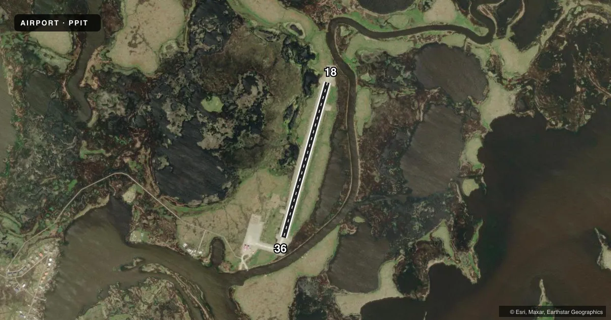
Airport sketch
Runways drawn to scale from FAA survey coordinates, rendered over satellite imagery. Not for navigation.
Approaches & charts
Services on the field
Fuel grades, oxygen, maintenance, ramp storage and lighting — as declared to the FAA by the airport operator.
Fuel & services
- Fuel
- Not available
Ramp & ground
- Transient storage
- Tie-down
- Lighting schedule
- SEE RMK
- Beacon schedule
- SS-SR
- Beacon
- White / Green (civil land)(WG)
- Wind indicator
- Lighted
- Segmented circle
- Yes
Fuel & FBOs
Cheapest 100LL and Jet A on the field and nearby. Always confirm with the FBO before taxi.
Airport notes
Surface conditions, obstructions, local procedures, lighting outages and other notes published with each FAA cycle.
General notes
- RWY COND NOT MNT; RCMD VISUAL INSP PRIOR TO USE.
- WX CAMERA AVBL ON INTERNET AT HTTPS://WEATHERCAMS.FAA.GOV
- BIRDS INVOF ARPT.
- BOATS IN BEACHING AREA.
Lighting notes
- ACTVT REIL RWY 18 & 36; PAPI RWY 18 & 36; MIRL RWY 18/36 - CTAF.
Approach & departure obstructions
- 36PAPI UNUSBL BYD 6 DEGS LEFT & RIGHT OF CNTRLN.
VFR map & nearby airports
VFR sectional. Tap any ICAO chip to open that airport.
Key facts · PPIT
Answer card- ICAO
- PPIT
- Name
- NUNAPITCHUK
- Location
- NUNAPITCHUK, ALASKA
- Elevation
- 21.9 ft MSL
- Traffic pattern altitude
- 1,021.9 ft MSL (1,000 AGL)
- Control tower
- Non-towered (use CTAF)
- Total runways
- 1
- Longest runway
- 18/36 · 2,420 ft
- Published ILS approaches
- 0
- Published frequencies
- 1
- Magnetic variation
- 18°
- Current flight rules
- VFR
- Current wind
- 070° at 3 kt
- Favored runway now
- RWY 36
Nunapitchuk Airport (PPIT) sits in Nunapitchuk, Alaska. The field elevation is 21.9 ft MSL. It has one runway. Runway 18/36 is 2,420 ft long with a gravel-dirt surface. The airport is not towered. CTAF is 122.9. No ILS approaches are published here.
The published pattern altitude is not listed. For light piston operations, use 1,000 ft AGL unless the current Chart Supplement says otherwise. That puts you at about 1,022 ft MSL based on the field elevation. Runway lighting is available on 18/36. The runway end identifier lights and PAPI are also published for both ends. Lighting is controlled through the CTAF. The runway condition is not maintained, so a visual inspection before use is a good idea. Boats are reported in the beaching area. Birds are also in the vicinity.
There are no on-field FBOs listed in the facts. Check with the airport operator or the FBO directly by phone before arrival if you need current services. The airport is in a low-elevation coastal setting in western Alaska. Expect to plan for local weather, surface condition and wildlife on the field. Runway 36 has a published note that the PAPI is unusable more than 6 degrees left or right of centerline.