METAR & TAF PFKW
Current METAR
Observed 06:56Z
PFKW 150656Z AUTO 21003KT 10SM CLR M20/M22 A3042 RMK AO2 SLP303 T12001217 FZRANO $
- Wind
- 210° @ 3 kt
- Visibility
- 10 SM
- Temp / Dew
- -20°C / -22°C
- Altimeter
- 30.42 inHg
- Clouds
- CLR
- Density alt
- -4,789 ft
- Ceiling
- Unlimited
- Rules
- VFR
Airport info & contacts
Manager on record, flight service, ARTCC, attendance schedule and pattern altitude — published by the FAA and refreshed every 28 days.
Location
- From city
- 1 NM SSW
- VFR sectional
- MC GRATH
- ARTCC
- ZAN · ANCHORAGE
- NOTAM facility
- KWT (NOTAM-D)
Airport manager
- Name
- JOSEPH LARAUX
- Phone
- (907) 543-2498
- Address
- PO BOX 505, BETHEL AK 99559
Flight service · Hours
- FSS ENA
- KENAI907-283-72111-866-864-1737
- Attendance
- Unattended
Frequencies
Tap any row to copy the frequency to your clipboard.
Runways & pattern
Full pagePattern entry · RWY 18
LEFT TRAFFICRunway end performance
| End | TORA | TODA | ASDA | LDA | VGSI | Approach lights | Obstruction |
|---|---|---|---|---|---|---|---|
| 18 | — | — | — | — | PAPI 4-box left(3°) | — | 8', brush, 0' from thr, 40' R of cntrln, slope 0 |
| 36 | — | — | — | — | PAPI 4-box left(3.2°) | — | 10', brush, 0' from thr, 90' R of cntrln, slope 0 |
Declared distances in feet. TORA = takeoff run available, TODA = takeoff distance, ASDA = accelerate-stop, LDA = landing distance.
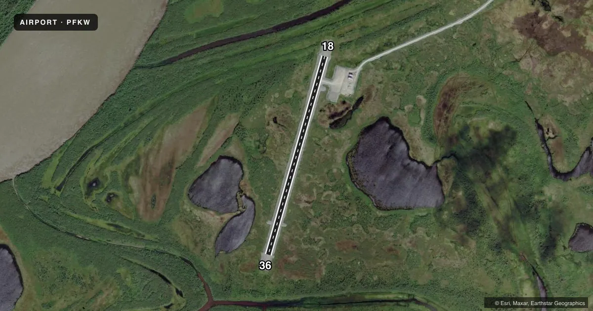
Airport sketch
Runways drawn to scale from FAA survey coordinates, rendered over satellite imagery. Not for navigation.
Approaches & charts
Services on the field
Fuel grades, oxygen, maintenance, ramp storage and lighting — as declared to the FAA by the airport operator.
Fuel & services
- Fuel
- Not available
Ramp & ground
- Transient storage
- Not published
- Landing fee
- No fee published
- Customs
- Not available
- Lighting schedule
- SEE RMK
- Beacon schedule
- SEE RMK
- Beacon
- White / Green (civil land)(WG)
- Wind indicator
- Lighted
- Segmented circle
- Yes
Fuel & FBOs
Cheapest 100LL and Jet A on the field and nearby. Always confirm with the FBO before taxi.
Airport notes
Surface conditions, obstructions, local procedures, lighting outages and other notes published with each FAA cycle.
General notes
- RY COND NOT MONITORED; RECOMMEND VISUAL INSPECTION PRIOR TO USING.
- WX CAMERA AVBL ON INTERNET AT HTTPS://WEATHERCAMS.FAA.GOV
- NUMEROUS ARPTS IN THE VICINITY.
- WEEDS IN FRONT OF BOTH PAPI INDICATORS.
- WINDSOCKS MAY BE UNRELIABLE
Lighting notes
- ACTVT ROTG BCN - CTAF.
- ACTVT MIRL RY 18/36; PAPI & REIL RYS 18 & 36 - CTAF.
Runway surface & condition
- 18/36LGTS PARTIALLY OBSCURED BY BRUSH AND GRASS.
Other notes
- THIS AIRPORT HAS BEEN SURVEYED BY THE NATIONAL GEODETIC SURVEY.
- MANAGER907-543-2498
- 18/36HEAVES, RUTS & EROSION CHANNELS ALONG RWY SFC.
- 18/36RUTS AT RWY ENDS.
VFR map & nearby airports
VFR sectional. Tap any ICAO chip to open that airport.
Key facts · PFKW
Answer card- ICAO
- PFKW
- Name
- KWETHLUK
- Location
- KWETHLUK, ALASKA
- Elevation
- 25.3 ft MSL
- Traffic pattern altitude
- 1,025.3 ft MSL (1,000 AGL)
- Control tower
- Non-towered (use CTAF)
- Total runways
- 1
- Longest runway
- 18/36 · 3,199 ft
- Published ILS approaches
- 0
- Published frequencies
- 1
- Magnetic variation
- 14°
- Current flight rules
- VFR
- Current wind
- 210° at 3 kt
- Favored runway now
- RWY 18
Kwethluk Airport sits in Kwethluk, Alaska. Field elevation is 25.3 ft MSL. The airport has one runway. Runway 18/36 is 3,199 ft long and gravel. There is no control tower. CTAF is 122.9.
No ILS approaches are published here. The pattern altitude is not published, so use the standard 1,000 ft AGL for light piston operations unless the current FAA Chart Supplement says otherwise. Runway 18/36 has medium intensity lights. The lights are activated by CTAF. PAPI and runway end identifier lights are also on 18 and 36. The published remarks say the runway has ruts at both ends. They also note heaves, ruts and erosion channels along the surface. Runway condition is not monitored, so a visual inspection before use is a good idea.
There are no on-field FBOs listed. Check with the airport operator or the field directly before arrival if you need local support. Windsocks may be unreliable. The remarks also note that lights can be partly hidden by brush and grass. This is a low-elevation Alaska field with no tower. Plan for self-announce traffic and keep an eye out for other nearby airports.