METAR & TAF PAHC
Current METAR
Observed 03:56Z
PAHC 280356Z AUTO 22007G16KT 180V240 8SM OVC048 13/09 A2996 RMK AO2 SLP149 T01280089
- Wind
- 220° @ 7G16 kt
- Visibility
- 8 SM
- Temp / Dew
- 13°C / 9°C
- Altimeter
- 29.96 inHg
- Clouds
- OVC
- Density alt
- -197 ft
- Ceiling
- 4,800 ft AGL
- Rules
- VFR
Airport info & contacts
Manager on record, flight service, ARTCC, attendance schedule and pattern altitude — published by the FAA and refreshed every 28 days.
Location
- From city
- 1 NM S
- VFR sectional
- MC GRATH
- ARTCC
- ZAN · ANCHORAGE
- NOTAM facility
- HCA (NOTAM-D)
Airport manager
- Name
- ERIK WEINGARTH
- Phone
- 907-438-2416
- Address
- BOX 135, ST MARY'S AK 99658
Flight service · Hours
- FSS ENA
- KENAI907-283-72111-866-864-1737
- Attendance
- Unattended
Frequencies
Tap any row to copy the frequency to your clipboard.
Runways & pattern
Full pagePattern entry · RWY 20
LEFT TRAFFICRunway end performance
| End | TORA | TODA | ASDA | LDA | VGSI | Approach lights | Obstruction |
|---|---|---|---|---|---|---|---|
| 02 | — | — | — | — | — | — | 40', trees, 0' from thr, 230' R of cntrln, slope 0 |
| 20 | — | — | — | — | — | — | 51', trees, 0' from thr, 214' R of cntrln, slope 0 |
Declared distances in feet. TORA = takeoff run available, TODA = takeoff distance, ASDA = accelerate-stop, LDA = landing distance.
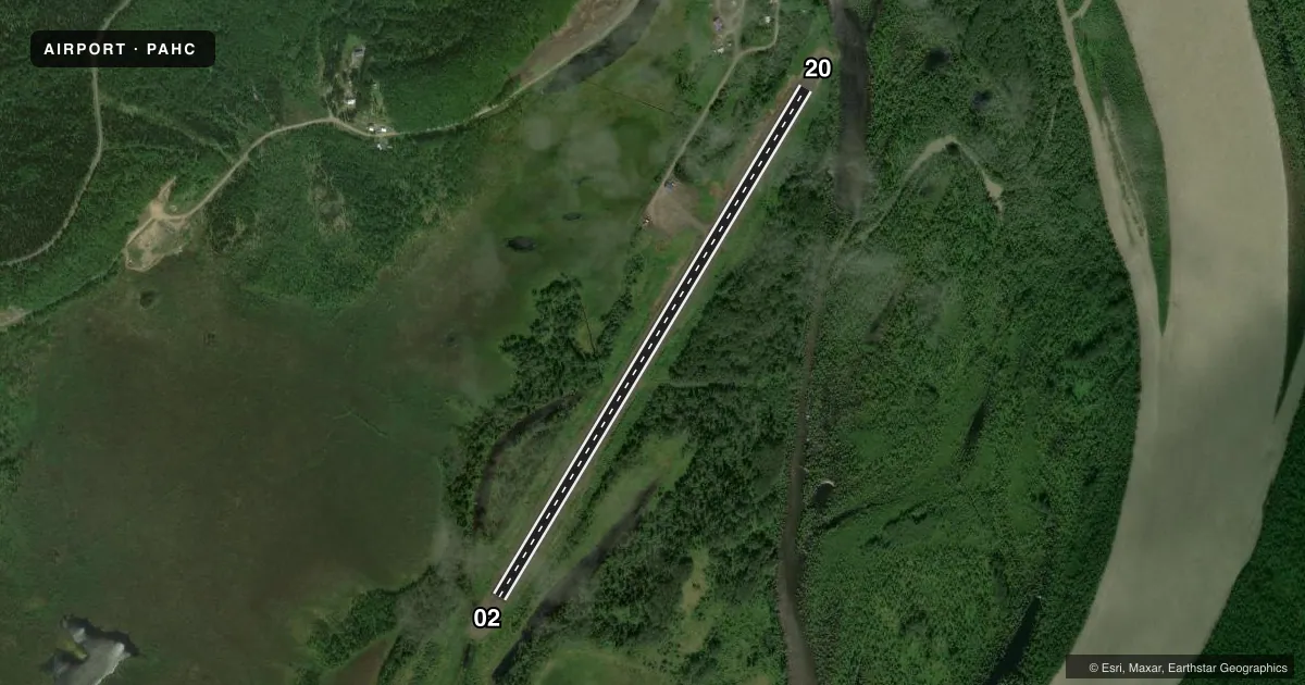
Airport sketch
Runways drawn to scale from FAA survey coordinates, rendered over satellite imagery. Not for navigation.
Approaches & charts
Services on the field
Fuel grades, oxygen, maintenance, ramp storage and lighting — as declared to the FAA by the airport operator.
Fuel & services
- Fuel
- Not available
- Oxygen (bottled)
- Not available
- Oxygen (bulk)
- Not available
- Airframe repair
- Major
- Power plant repair
- Major
Ramp & ground
- Transient storage
- Tie-down
- Landing fee
- No fee published
- Customs
- Not available
- Lighting schedule
- SEE RMK
- Beacon schedule
- SS-SR
- Beacon
- White / Green (civil land)(WG)
- Wind indicator
- Lighted
- Segmented circle
- Yes
Fuel & FBOs
Cheapest 100LL and Jet A on the field and nearby. Always confirm with the FBO before taxi.
Airport notes
Surface conditions, obstructions, local procedures, lighting outages and other notes published with each FAA cycle.
General notes
- RWY CONDITION NOT MONITORED; RECOMMEND VISUAL INSPECTION PRIOR TO LANDING.
- MOOSE ON AND INVOF ARPT.
- WX CAMERA AVBL ON INTERNET AT HTTPS://WEATHERCAMS.FAA.GOV
- COLD TEMPERATURE AIRPORT. ALTITUDE CORRECTION REQUIRED AT OR BELOW -28C.
Lighting notes
- ACVT MIRL RWY 02/20 - CTAF.
Other notes
- 02/20SHALLOW PONDING AT TWY AFTER RAIN.
VFR map & nearby airports
VFR sectional. Tap any ICAO chip to open that airport.
Key facts · PAHC
Answer card- ICAO
- PAHC
- Name
- HOLY CROSS
- Location
- HOLY CROSS, ALASKA
- Elevation
- 74.5 ft MSL
- Traffic pattern altitude
- 1,074.5 ft MSL (1,000 AGL)
- Control tower
- Non-towered (use CTAF)
- Total runways
- 1
- Longest runway
- 02/20 · 4,000 ft
- Published ILS approaches
- 0
- Published frequencies
- 1
- Magnetic variation
- 10°
- Current flight rules
- VFR
- Current wind
- 220° at 7 kt
- Favored runway now
- RWY 20
Holy Cross Airport (PAHC) is in Holy Cross, Alaska. The field elevation is 74.5 ft MSL. It has one runway. Runway 02/20 is 4,000 ft long and gravel. The longest runway is 4,000 ft.
There is no control tower. CTAF is 122.8. No ILS approaches are published here, so plan with current charts and weather in hand before you go. Pattern altitude is not published. Use 1,000 ft AGL for light piston operations unless the current Chart Supplement or local procedures say otherwise.
The published remarks matter here. Runway lights for 02/20 are activated by CTAF. Runway condition is not monitored, so a visual inspection before landing is a good idea. This is also a cold temperature airport. Altitude correction is required at or below minus 28 degrees Celsius. Shallow ponding can occur at the taxiway after rain. Moose are on and near the airport, so keep your scan outside on taxi and final. No on-field FBOs are listed, so verify services with the airport operator or the FBO directly by phone before arrival.