METAR & TAF PAGH
Current METAR
Observed 07:56Z
PAGH 280756Z AUTO 27009KT 10SM CLR 17/08 A2974 RMK AO2 SLP071 T01670078
- Wind
- 270° @ 9 kt
- Visibility
- 10 SM
- Temp / Dew
- 17°C / 8°C
- Altimeter
- 29.74 inHg
- Clouds
- CLR
- Density alt
- 717 ft
- Ceiling
- Unlimited
- Rules
- VFR
Airport info & contacts
Manager on record, flight service, ARTCC, attendance schedule and pattern altitude — published by the FAA and refreshed every 28 days.
Location
- From city
- 0 NM NW
- VFR sectional
- FAIRBANKS
- ARTCC
- ZAN · ANCHORAGE
- NOTAM facility
- SHG (NOTAM-D)
Airport manager
- Name
- ALVIN WERNEKE
- Phone
- 907-442-3147
- Address
- PO BOX 55, KOTZEBUE AK 99752
Flight service · Hours
- FSS OTZ
- KOTZEBUE907-442-33101-800-478-7460
- Attendance
- Unattended
Frequencies
Tap any row to copy the frequency to your clipboard.
Runways & pattern
Full pagePattern entry · RWY 28
LEFT TRAFFICRunway end performance
| End | TORA | TODA | ASDA | LDA | VGSI | Approach lights | Obstruction |
|---|---|---|---|---|---|---|---|
| 10 | — | — | — | — | PAPI 4-box right(3°) | — | 5', brush, 0' from thr, 50' R of cntrln, slope 0 |
| 28 | — | — | — | — | — | — | 5', brush, 0' from thr, 62' R of cntrln, slope 0 |
Declared distances in feet. TORA = takeoff run available, TODA = takeoff distance, ASDA = accelerate-stop, LDA = landing distance.
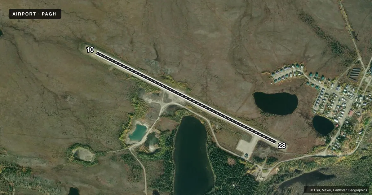
Airport sketch
Runways drawn to scale from FAA survey coordinates, rendered over satellite imagery. Not for navigation.
Approaches & charts
Services on the field
Fuel grades, oxygen, maintenance, ramp storage and lighting — as declared to the FAA by the airport operator.
Fuel & services
- Fuel
- Not available
Ramp & ground
- Transient storage
- Not published
- Landing fee
- No fee published
- Customs
- Not available
- Lighting schedule
- SEE RMK
- Beacon schedule
- SS-SR
- Beacon
- White / Green (civil land)(WG)
- Wind indicator
- Lighted
- Segmented circle
- Yes
Fuel & FBOs
Cheapest 100LL and Jet A on the field and nearby. Always confirm with the FBO before taxi.
Airport notes
Surface conditions, obstructions, local procedures, lighting outages and other notes published with each FAA cycle.
General notes
- RWY COND UNMNT; RCMD VISUAL INSP BFR LNDG.
- WX CAMERA AVBL ON INTERNET AT HTTPS://WEATHERCAMS.FAA.GOV
- COLD TEMPERATURE AIRPORT. ALTITUDE CORRECTION REQUIRED AT OR BELOW -32C.
Lighting notes
- ACTVT PAPI RWY 10; MIRL RWY 10/28 - CTAF.
Approach & departure obstructions
- 10UPHILL SLOPE BFR APRON ENTRY.
- 10LGTS & PLASTIC MKRS.
- 28LGTS & PLASTIC MKRS.
Other notes
- 10/28WATER PONDING DURG RAIN.
VFR map & nearby airports
VFR sectional. Tap any ICAO chip to open that airport.
Key facts · PAGH
Answer card- ICAO
- PAGH
- Name
- SHUNGNAK
- Location
- SHUNGNAK, ALASKA
- Elevation
- 205 ft MSL
- Traffic pattern altitude
- 1,205 ft MSL (1,000 AGL)
- Control tower
- Non-towered (use CTAF)
- Total runways
- 1
- Longest runway
- 10/28 · 4,001 ft
- Published ILS approaches
- 0
- Published frequencies
- 1
- Magnetic variation
- 13°
- Current flight rules
- VFR
- Current wind
- 270° at 9 kt
- Favored runway now
- RWY 28
Shungnak Airport sits in Shungnak, Alaska. Field elevation is 205 ft MSL. The airport has one runway. Runway 10/28 is 4,001 ft of gravel. There is no control tower. CTAF is 122.7. No ILS approaches are published here.
Pattern altitude is not published. Use 1,000 ft AGL for light piston traffic unless the current Chart Supplement or local procedures say otherwise. Runway headings are magnetic. Runway 10 is 117° magnetic. Runway 28 is 297° magnetic. Published remarks say water can pond on the runway during rain. Runway condition is unmonitored. A visual check before landing is a good idea. This is also a cold temperature airport. Altitude correction is required at or below minus 32 degrees Celsius.
Runway 10 has lights, plastic markers and PAPI. Medium intensity runway lights on 10 and 28 are activated by CTAF. There is also an uphill slope before the apron entry at runway 10. No on-field FBOs are listed, so verify services with the airport operator or call the field directly before you go. For a first trip, plan for gravel surface performance, cold weather effects and limited published approach support. Check the current Chart Supplement for any local notes before departure.