METAR & TAF PAFM
Current METAR
Observed 06:56Z
PAFM 280656Z AUTO RMK AO2 SLPNO PWINO FZRANO $
- Wind
- Calm
- Visibility
- —
- Temp / Dew
- —
- Altimeter
- —
- Clouds
- Clear
- Density alt
- —
- Ceiling
- Unlimited
- Rules
- VFR
Airport info & contacts
Manager on record, flight service, ARTCC, attendance schedule and pattern altitude — published by the FAA and refreshed every 28 days.
Location
- From city
- 1 NM N
- VFR sectional
- FAIRBANKS
- ARTCC
- ZAN · ANCHORAGE
- NOTAM facility
- AFM (NOTAM-D)
Airport manager
- Name
- ALVIN WERNEKE
- Phone
- 907-442-3147
- Address
- BOX 55, KOTZEBUE AK 99752
Flight service · Hours
- FSS OTZ
- KOTZEBUE907-442-33101-800-478-7460
- Attendance
- Unattended
Frequencies
Tap any row to copy the frequency to your clipboard.
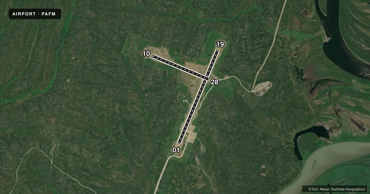
Runways & pattern
Full pagePattern entry · RWY 01
LEFT TRAFFIC| Runway | Heading (°M) | Length | Surface | Traffic |
|---|---|---|---|---|
| 01/19 | 10° / 190° | 4,000 ft | GRVL-DIRT | Standard L |
| 10/28 | 100° / 280° | 2,400 ft | GRVL-DIRT | Standard L |
Runway end performance
| End | TORA | TODA | ASDA | LDA | VGSI | Approach lights | Obstruction |
|---|---|---|---|---|---|---|---|
| 01 | — | — | — | — | PAPI 4-box right(3°) | — | 10', trees, 315' from thr, 140' R of cntrln, slope 31 |
| 19 | — | — | — | — | — | — | 13', trees, 0' from thr, 180' R of cntrln, slope 0 |
Declared distances in feet. TORA = takeoff run available, TODA = takeoff distance, ASDA = accelerate-stop, LDA = landing distance.
Airport sketch
Runways drawn to scale from FAA survey coordinates, rendered over satellite imagery. Not for navigation.
Approaches & charts
Services on the field
Fuel grades, oxygen, maintenance, ramp storage and lighting — as declared to the FAA by the airport operator.
Fuel & services
- Fuel
- Not available
- Oxygen (bottled)
- Not available
- Oxygen (bulk)
- Not available
- Airframe repair
- Not available
- Power plant repair
- Not available
Ramp & ground
- Transient storage
- Not published
- Landing fee
- No fee published
- Customs
- Not available
- Lighting schedule
- SEE RMK
- Beacon schedule
- SEE RMK
- Beacon
- White / Green (civil land)(WG)
- Wind indicator
- Lighted
- Segmented circle
- Yes
Fuel & FBOs
Cheapest 100LL and Jet A on the field and nearby. Always confirm with the FBO before taxi.
Airport notes
Surface conditions, obstructions, local procedures, lighting outages and other notes published with each FAA cycle.
General notes
- CARIBOU INVOF RY.
- RY CONDITIONS NOT MONITORED; RECOMMEND VISUAL INSPECTION PRIOR TO LANDING.
- WX CAMERA AVBL ON INTERNET AT HTTPS://WEATHERCAMS.FAA.GOV
- COLD TEMPERATURE AIRPORT. ALTITUDE CORRECTION REQUIRED AT OR BELOW -36C.
Lighting notes
- ACTVT ROTG BCN - CTAF.
- ACTVT PAPI RWY 01; MIRL RWY 01/19 & 10/28; WINDSOCK LIGHTS - CTAF.
Runway surface & condition
- 01/19CROWNS IN CENTER & NO LINE OF SIGHT BTW RWY ENDS.
- 10/28RWY SLOPES UPHILL EAST TO WEST APPX 80 FT.
Other notes
- 01/19RWY SURFACE IS COMPACTED GRAVEL, ROCK AND DIRT. SURFACE TYPE LISTED AS GRAVEL-DIRT.
- 10/28RWY SURFACE IS COMPACTED GRAVEL, ROCK AND DIRT. SURFACE TYPE LISTED AS GRAVEL-DIRT.
VFR map & nearby airports
VFR sectional. Tap any ICAO chip to open that airport.
Key facts · PAFM
Answer card- ICAO
- PAFM
- Name
- AMBLER
- Location
- AMBLER, ALASKA
- Elevation
- 292.6 ft MSL
- Traffic pattern altitude
- 1,292.6 ft MSL (1,000 AGL)
- Control tower
- Non-towered (use CTAF)
- Total runways
- 2
- Longest runway
- 01/19 · 4,000 ft
- Published ILS approaches
- 0
- Published frequencies
- 1
- Magnetic variation
- 13°
- Current flight rules
- VFR
- Current wind
- Calm / unavailable
- Favored runway now
- –
Ambler Airport sits in Ambler, Alaska at 292.6 ft MSL. It has two runways. The longest is 01/19 at 4,000 ft. The field is non-towered. CTAF is 122.7. No ILS approaches are published here. The pattern altitude is not published, so use the standard 1,000 ft AGL for light piston traffic unless the current Chart Supplement says otherwise.
Both runways are gravel-dirt surfaces made up of compacted gravel, rock and dirt. Runway 10/28 is 2,400 ft. Runway 10/28 slopes uphill from east to west by about 80 ft. Runway 01/19 has crowns in the center. There is no line of sight between the ends of 01/19. Plan your traffic and spacing with that in mind. A rotating beacon is activated on the CTAF. Medium intensity runway lights are on 01/19 and 10/28. PAPI is activated on runway 01. Windsock lights are also activated on the CTAF.
This is a cold temperature airport. Altitude correction is required at or below minus 36 degrees Celsius. Caribou may be in the vicinity of the runway. Runway conditions are not monitored. A visual inspection before landing is smart. No on-field FBOs are listed. Check with the airport operator or the FBO directly by phone before arrival if you need current services.