METAR & TAF PODC
PODC does not publish a METAR.
Showing the nearest reporting station: PAGH (SHUNGNAK) · 7.2 NM away. Conditions at PODC may differ.
METAR · PAGH
Observed 20:56Z
PAGH 272056Z AUTO 29009KT 10SM CLR 19/09 A2980 RMK AO2 SLP092 T01940094 58007
- Wind
- 290° @ 9 kt
- Visibility
- 10 SM
- Temp / Dew
- 19°C / 9°C
- Altimeter
- 29.80 inHg
- Clouds
- CLR
- Density alt
- 951 ft
- Ceiling
- Unlimited
- Rules
- VFR
Airport info & contacts
Manager on record, flight service, ARTCC, attendance schedule and pattern altitude — published by the FAA and refreshed every 28 days.
Location
- From city
- 10 NM SE
- VFR sectional
- FAIRBANKS
- ARTCC
- ZAN · ANCHORAGE
- NOTAM facility
- OTZ (NOTAM-D)
Airport manager
- Name
- ALVIN WERNEKE
- Phone
- 907-442-3147
- Address
- BOX 55, KOTZEBUE AK 99752
Flight service · Hours
- FSS OTZ
- KOTZEBUE907-442-33101-800-478-7460
- Attendance
- Unattended
Frequencies
Tap any row to copy the frequency to your clipboard.
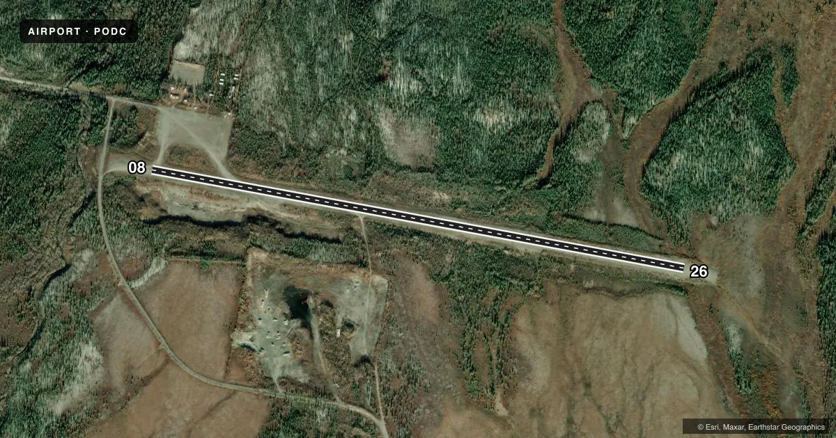
Runways & pattern
Full pagePattern entry · RWY 26
LEFT TRAFFICRunway end performance
| End | TORA | TODA | ASDA | LDA | VGSI | Approach lights | Obstruction |
|---|---|---|---|---|---|---|---|
| 08 | — | — | — | — | — | — | 9', brush, 0' from thr, 80' R of cntrln, slope 0 |
| 26 | — | — | — | — | — | — | 11', brush, 0' from thr, 80' R of cntrln, slope 0 |
Declared distances in feet. TORA = takeoff run available, TODA = takeoff distance, ASDA = accelerate-stop, LDA = landing distance.
Airport sketch
Runways drawn to scale from FAA survey coordinates, rendered over satellite imagery. Not for navigation.
Approaches & charts
Services on the field
Fuel grades, oxygen, maintenance, ramp storage and lighting — as declared to the FAA by the airport operator.
Fuel & services
- Fuel
- Not available
- Oxygen (bottled)
- Not available
- Oxygen (bulk)
- Not available
- Airframe repair
- Not available
- Power plant repair
- Not available
Ramp & ground
- Transient storage
- Not published
- Landing fee
- No fee published
- Customs
- Not available
- Wind indicator
- Yes
- Segmented circle
- Yes
Fuel & FBOs
Cheapest 100LL and Jet A on the field and nearby. Always confirm with the FBO before taxi.
Airport notes
Surface conditions, obstructions, local procedures, lighting outages and other notes published with each FAA cycle.
General notes
- CARIBOU MAY BE ON RY.
- HIGH TERRAIN NORTH.
- ARPT NOT MAINTAINED; NO SNOW REMOVAL; RY CONDITION NOT MONITORED. RECOMMEND VISUAL INSPECTION PRIOR TO LANDING.
- RY 08/26 ALSO USED AS A ROAD.
- WIND SOCK DAMAGED AND NOT RELIABLE, SEGMENTED CIRCLE AND WIND SOCK ARE OVERGROWN WITH BRUSH AND TREES
Other notes
- ESTABD PRIOR TO 1959.
- NORTHWEST ARCTIC BOROUGH
- 08/26GRASS GROWING ON RY; DIP FORMING APRXLY 250 FT FROM RY 26 THLD & 2 IN WIDE EROSION CHANNELS DEVELOPING FROM CENTER LINE TO SOUTH EDGE; RY NO LONGER MAINTAINED.
VFR map & nearby airports
VFR sectional. Tap any ICAO chip to open that airport.
Key facts · PODC
Answer card- ICAO
- PODC
- Name
- DAHL CREEK
- Location
- DAHL CREEK, ALASKA
- Elevation
- 260 ft MSL
- Traffic pattern altitude
- 1,260 ft MSL (1,000 AGL)
- Control tower
- Non-towered (use CTAF)
- Total runways
- 1
- Longest runway
- 08/26 · 4,780 ft
- Published ILS approaches
- 0
- Published frequencies
- 1
- Magnetic variation
- 23°
- Current flight rules
- VFR
- Current wind
- 290° at 9 kt
- Favored runway now
- RWY 26
Dahl Creek Airport (PODC) sits in Dahl Creek, Alaska. Field elevation is 260 ft MSL. The airport has one runway. Runway 08/26 is 4,780 ft long and gravel. The field is not towered, so use CTAF 122.7 for traffic calls.
No ILS approaches are published here. Pattern altitude is not published, so use the standard 1,000 ft AGL for light piston operations unless the current Chart Supplement says otherwise. The published remarks matter here. Runway 08/26 is also used as a road. The runway is no longer maintained. Grass is growing on it. A dip is forming near the Runway 26 end. Erosion channels are developing. A visual inspection before landing is a smart move.
There is no on-field FBO listed. Check with the airport operator or the field directly by phone before you go. High terrain is north of the airport. Caribou may be on the runway. The wind sock is damaged and not reliable. The segmented circle and wind sock area are overgrown with brush and trees. This is a remote Alaska strip with no snow removal and no runway condition monitoring, so treat surface conditions as a real planning item before arrival.