METAR & TAF PAOB
PAOB does not publish a METAR.
Showing the nearest reporting station: PAGH (SHUNGNAK) · 6.4 NM away. Conditions at PAOB may differ.
METAR · PAGH
Observed 04:56Z
PAGH 280456Z AUTO 30013KT 10SM CLR 23/09 A2972 RMK AO2 SLP065 T02280089
- Wind
- 300° @ 13 kt
- Visibility
- 10 SM
- Temp / Dew
- 23°C / 9°C
- Altimeter
- 29.72 inHg
- Clouds
- CLR
- Density alt
- 1,384 ft
- Ceiling
- Unlimited
- Rules
- VFR
Airport info & contacts
Manager on record, flight service, ARTCC, attendance schedule and pattern altitude — published by the FAA and refreshed every 28 days.
Location
- From city
- 0 NM N
- VFR sectional
- FAIRBANKS
- ARTCC
- ZAN · ANCHORAGE
- NOTAM facility
- OTZ (NOTAM-D)
Airport manager
- Name
- ALVIN WERNEKE
- Phone
- 907-442-3147
- Address
- BOX 55, KOTZUBUE AK 99752
Flight service · Hours
- FSS OTZ
- KOTZEBUE907-442-33101-800-478-7460
- Attendance
- Unattended
Frequencies
Tap any row to copy the frequency to your clipboard.
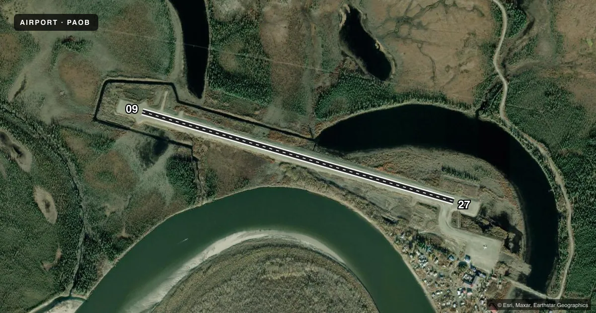
Runways & pattern
Full pagePattern entry · RWY 27
LEFT TRAFFICRunway end performance
| End | TORA | TODA | ASDA | LDA | VGSI | Approach lights | Obstruction |
|---|---|---|---|---|---|---|---|
| 09 | — | — | — | — | — | — | 6', brush, 0' from thr, 126' R of cntrln, slope 0 |
| 27 | — | — | — | — | — | — | 25', brush, 0' from thr, 126' R of cntrln, slope 0 |
Declared distances in feet. TORA = takeoff run available, TODA = takeoff distance, ASDA = accelerate-stop, LDA = landing distance.
Airport sketch
Runways drawn to scale from FAA survey coordinates, rendered over satellite imagery. Not for navigation.
Approaches & charts
Services on the field
Fuel grades, oxygen, maintenance, ramp storage and lighting — as declared to the FAA by the airport operator.
Fuel & services
- Fuel
- Not available
Ramp & ground
- Transient storage
- Not published
- Landing fee
- No fee published
- Customs
- Not available
- Lighting schedule
- SEE RMK
- Beacon schedule
- SS-SR
- Beacon
- White / Green (civil land)(WG)
- Wind indicator
- Lighted
- Segmented circle
- Yes
Fuel & FBOs
Cheapest 100LL and Jet A on the field and nearby. Always confirm with the FBO before taxi.
Airport notes
Surface conditions, obstructions, local procedures, lighting outages and other notes published with each FAA cycle.
General notes
- RWY COND UNMNT; RCMD VISUAL INSP BFR LNDG.
- FLOAT PLANE OPS ON LAKE.
- WX CAMERA AVBL ON INTERNET AT HTTPS://WEATHERCAMS.FAA.GOV
- COLD TEMPERATURE AIRPORT. ALTITUDE CORRECTION REQUIRED AT OR BELOW -37C.
Lighting notes
- ACTVT MIRL RWY 09/27 - CTAF.
Runway surface & condition
- 09/27PARL PWR LINE N.
Approach & departure obstructions
- 09DIP ABEAM SLOUGH.
Other notes
- ESTABD PRIOR TO 1959.
VFR map & nearby airports
VFR sectional. Tap any ICAO chip to open that airport.
Key facts · PAOB
Answer card- ICAO
- PAOB
- Name
- KOBUK
- Location
- KOBUK, ALASKA
- Elevation
- 142.2 ft MSL
- Traffic pattern altitude
- 1,142.2 ft MSL (1,000 AGL)
- Control tower
- Non-towered (use CTAF)
- Total runways
- 1
- Longest runway
- 09/27 · 4,020 ft
- Published ILS approaches
- 0
- Published frequencies
- 1
- Magnetic variation
- 11°
- Current flight rules
- VFR
- Current wind
- 300° at 13 kt
- Favored runway now
- RWY 27
PAOB is the airport serving Kobuk, Alaska. The field elevation is 142.2 ft MSL. It has one runway. Runway 09/27 is 4,020 ft long and gravel. The airport is not towered. CTAF is 122.7. No ILS approaches are published here. Pattern altitude is not published, so use the standard 1,000 ft AGL for light piston operations unless the current Chart Supplement says otherwise.
There are no on-field FBOs listed in the facts. Plan on self-sufficiency before you go. The published remarks matter here. Runway condition is unmonitored, so a visual inspection before landing is a good idea. There is a parallel power line north of the runway. Runway 09 has a dip abeam the slough at the departure end. Float plane operations also occur on the lake, so expect mixed traffic in the area. The airport is cold-weather sensitive. Altitude correction is required at or below minus 37 degrees Celsius.
This is a remote Alaska field with gravel surface and no tower. Check density altitude, surface condition and winds before committing. The runway lights on 09/27 are medium intensity. They are activated by CTAF. A weather camera is available online for a current look at conditions.