METAR & TAF PAKP
Current METAR
Observed 02:56Z
PAKP 280256Z AUTO 05018G23KT 10SM FEW027 08/05 A2992 RMK AO2 SLP160 T00830050 50002 $
- Wind
- 050° @ 18G23 kt
- Visibility
- 10 SM
- Temp / Dew
- 8°C / 5°C
- Altimeter
- 29.92 inHg
- Clouds
- FEW
- Density alt
- 1,772 ft
- Ceiling
- Unlimited
- Rules
- VFR
Airport info & contacts
Manager on record, flight service, ARTCC, attendance schedule and pattern altitude — published by the FAA and refreshed every 28 days.
Location
- From city
- 0 NM SE
- VFR sectional
- POINT BARROW
- ARTCC
- ZAN · ANCHORAGE
- NOTAM facility
- AKP (NOTAM-D)
Airport manager
- Name
- GEORGE AHMAOGAK, JR
- Phone
- (907) 852-0489
- Address
- BOX 69, BARROW AK 99723
Flight service · Hours
- FSS FAI
- FAIRBANKS907-474-07881-866-248-6516
- Attendance
- ALL
Frequencies
Tap any row to copy the frequency to your clipboard.
Runways & pattern
Full pagePattern entry · RWY 02
LEFT TRAFFICRunway end performance
| End | TORA | TODA | ASDA | LDA | VGSI | Approach lights | Obstruction |
|---|---|---|---|---|---|---|---|
| 02 | — | — | — | — | PAPI 2-box left(3°) | — | 7', brush, 0' from thr, 120' R of cntrln, slope 0 |
| 20 | — | — | — | — | PAPI 2-box left(3°) | — | 22', brush, 340' from thr, 120' R of cntrln, slope 17 |
Declared distances in feet. TORA = takeoff run available, TODA = takeoff distance, ASDA = accelerate-stop, LDA = landing distance.
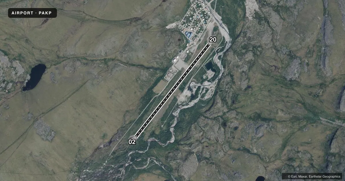
Airport sketch
Runways drawn to scale from FAA survey coordinates, rendered over satellite imagery. Not for navigation.
Approaches & charts
Services on the field
Fuel grades, oxygen, maintenance, ramp storage and lighting — as declared to the FAA by the airport operator.
Fuel & services
- Fuel
- Not available
Ramp & ground
- Transient storage
- Not published
- Landing fee
- No fee published
- Customs
- Not available
- Lighting schedule
- SEE RMK
- Beacon schedule
- SEE RMK
- Beacon
- White / Green (civil land)(WG)
- Wind indicator
- No
- Segmented circle
- Yes
Fuel & FBOs
Cheapest 100LL and Jet A on the field and nearby. Always confirm with the FBO before taxi.
Airport notes
Surface conditions, obstructions, local procedures, lighting outages and other notes published with each FAA cycle.
General notes
- WX CAMERA AVBL ON INTERNET AT HTTPS://WEATHERCAMS.FAA.GOV
- COLD TEMPERATURE AIRPORT. ALTITUDE CORRECTION REQUIRED AT OR BELOW -31C.
Lighting notes
- ACTVT ROTG BCN - CTAF.
- ACTVT MIRL RY 02/20; REIL & PAPI RYS 02 & 20 - CTAF.
Runway surface & condition
- 02/20ALERT: LCTD IN VALLEY; HIGH TRRN ALL QUADS; EXP TURB WIND; RCMD VISUAL INSP PRIOR TO USE.
VFR map & nearby airports
VFR sectional. Tap any ICAO chip to open that airport.
Key facts · PAKP
Answer card- ICAO
- PAKP
- Name
- ANAKTUVUK PASS
- Location
- ANAKTUVUK PASS, ALASKA
- Elevation
- 2,106.3 ft MSL
- Traffic pattern altitude
- 3,106.3 ft MSL (1,000 AGL)
- Control tower
- Non-towered (use CTAF)
- Total runways
- 1
- Longest runway
- 02/20 · 4,800 ft
- Published ILS approaches
- 0
- Published frequencies
- 2
- Magnetic variation
- 16°
- Current flight rules
- VFR
- Current wind
- 050° at 18 kt
- Favored runway now
- RWY 02
Anaktuvuk Pass Airport sits in Anaktuvuk Pass, Alaska. Field elevation is 2,106.3 ft MSL. The airport has one runway. Runway 02/20 is 4,800 ft long and gravel. No ILS approaches are published here.
This is an unattended field. There is no control tower. CTAF and UNICOM are both 122.8. Pattern altitude is not published. Use the standard 1,000 ft AGL for light piston traffic unless the current Chart Supplement says otherwise. The published runway lighting is useful after dark. Medium intensity runway lights are on runway 02/20. REILs and PAPI are activated on the CTAF. The rotating beacon is also activated on the CTAF.
The airport sits in a valley with high terrain in all quadrants. Expect turbulence and wind. A visual inspection before use is recommended. This is also a cold temperature airport. Altitude correction is required at or below minus 31 degrees Celsius. There are no on-field FBOs listed, so plan fuel and ground support with the airport operator or the FBO directly by phone before arrival. For a first trip in, the terrain and weather deserve as much attention as the runway itself.