METAR & TAF PAUM
PAUM does not publish a METAR.
Showing the nearest reporting station: PAQT (NUIQSUT) · 55.5 NM away. Conditions at PAUM may differ.
METAR · PAQT
Observed 03:53Z
PAQT 280353Z AUTO 03010KT 10SM -RA CLR 07/01 A3011 RMK AO2 SLP197 P0000 T00670006 TSNO $
- Wind
- 030° @ 10 kt
- Visibility
- 10 SM
- Temp / Dew
- 7°C / 1°C
- Altimeter
- 30.11 inHg
- Clouds
- CLR
- Density alt
- -864 ft
- Ceiling
- Unlimited
- Rules
- VFR
Airport info & contacts
Manager on record, flight service, ARTCC, attendance schedule and pattern altitude — published by the FAA and refreshed every 28 days.
Location
- From city
- 0 NM N
- VFR sectional
- POINT BARROW
- ARTCC
- ZAN · ANCHORAGE
- NOTAM facility
- FAI (NOTAM-D)
Airport manager
- Name
- JASON LUDINGTON
- Phone
- (907) 451-5280
- Address
- FAIRBANKS AK 99709
Flight service · Hours
- FSS FAI
- FAIRBANKS907-474-07881-866-248-6516
- Attendance
- Unattended
Frequencies
Tap any row to copy the frequency to your clipboard.
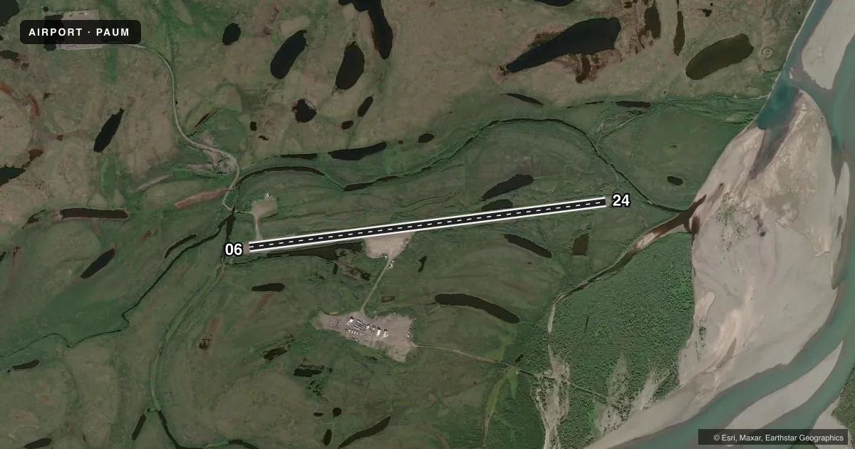
Runways & pattern
Full pagePattern entry · RWY 06
LEFT TRAFFICRunway end performance
| End | TORA | TODA | ASDA | LDA | VGSI | Approach lights | Obstruction |
|---|---|---|---|---|---|---|---|
| 06 | — | — | — | — | — | — | 11', brush, 0' from thr, 104' R of cntrln, slope 0 |
| 24 | — | — | — | — | — | — | 6', brush, 0' from thr, 82' R of cntrln, slope 0 |
Declared distances in feet. TORA = takeoff run available, TODA = takeoff distance, ASDA = accelerate-stop, LDA = landing distance.
Airport sketch
Runways drawn to scale from FAA survey coordinates, rendered over satellite imagery. Not for navigation.
Approaches & charts
Services on the field
Fuel grades, oxygen, maintenance, ramp storage and lighting — as declared to the FAA by the airport operator.
Fuel & services
- Fuel
- Not available
- Oxygen (bottled)
- Not available
- Oxygen (bulk)
- Not available
- Airframe repair
- Not available
- Power plant repair
- Not available
Ramp & ground
- Transient storage
- Not published
- Landing fee
- No fee published
- Customs
- Not available
- Beacon schedule
- SS-SR
- Beacon
- White / Green (civil land)(WG)
- Wind indicator
- Yes
- Segmented circle
- No
Fuel & FBOs
Cheapest 100LL and Jet A on the field and nearby. Always confirm with the FBO before taxi.
Airport notes
Surface conditions, obstructions, local procedures, lighting outages and other notes published with each FAA cycle.
General notes
- MTN RIDGES N & S.
- RY CONDITION NOT MONITORED; RECOMMEND VISUAL INSPECTION PRIOR TO LANDING.
- WILDLIFE & BIRDS ON & INVOF RY.
- NO WINTER MAINTENANCE OR SNOW REMOVAL.
- WHEN AVBL WX RPRTS HRLY ONLY.
Other notes
- 06/24GRASS & WEEDS GROWING ON RY SFC WITH RUTS UP TO 4 IN. RY SOFT WHEN WET.
VFR map & nearby airports
VFR sectional. Tap any ICAO chip to open that airport.
Key facts · PAUM
Answer card- ICAO
- PAUM
- Name
- UMIAT
- Location
- UMIAT, ALASKA
- Elevation
- 267.6 ft MSL
- Traffic pattern altitude
- 1,267.6 ft MSL (1,000 AGL)
- Control tower
- Non-towered (use CTAF)
- Total runways
- 1
- Longest runway
- 06/24 · 5,583 ft
- Published ILS approaches
- 0
- Published frequencies
- 2
- Magnetic variation
- 21°
- Current flight rules
- VFR
- Current wind
- 030° at 10 kt
- Favored runway now
- RWY 06
Umiat Airport (PAUM) sits in Umiat, Alaska at 267.6 ft MSL. It has one runway, 06/24, which is 5,583 ft long. There is no control tower. CTAF and UNICOM are both 122.8. No ILS approaches are published.
The pattern altitude is not published, so use the standard 1,000 ft AGL unless the current Chart Supplement says otherwise. That puts the traffic pattern at about 1,267.6 ft MSL based on field elevation, but verify before you fly. The runway surface is gravel-dirt. Published remarks say runway condition is not monitored. A visual check before landing is recommended. The surface can be soft when wet. Grass and weeds are growing on the runway. Ruts up to 4 inches are reported. No winter maintenance or snow removal is performed.
There are no on-field FBOs listed. Check with the airport operator or call the field on CTAF or UNICOM for current services before arrival. Wildlife and birds are reported on and near the runway. Mountain ridges lie north and south of the field. Weather reports, when available, are provided hourly only. Plan for a remote Alaska strip with limited support. Use a current sectional or the FAA Chart Supplement for any updates before departure.