METAR & TAF PAQT
Current METAR
Observed 23:26Z
PAQT 272326Z AUTO 01006KT 10SM -RA SCT018 OVC037 08/01 A3011 RMK AO2 P0000 T00780006 TSNO $
- Wind
- 010° @ 6 kt
- Visibility
- 10 SM
- Temp / Dew
- 8°C / 1°C
- Altimeter
- 30.11 inHg
- Clouds
- OVC
- Density alt
- -1,019 ft
- Ceiling
- 3,700 ft AGL
- Rules
- VFR
Airport info & contacts
Manager on record, flight service, ARTCC, attendance schedule and pattern altitude — published by the FAA and refreshed every 28 days.
Location
- From city
- 0 NM S
- VFR sectional
- POINT BARROW
- ARTCC
- ZAN · ANCHORAGE
- NOTAM facility
- AQT (NOTAM-D)
Airport manager
- Name
- GEORGE AHMAOGAK
- Phone
- 907-852-0489
- Address
- BOX 69, BARROW AK 99723
Flight service · Hours
- FSS SCC
- DEADHORSE907-659-2401LC659-2401
- Attendance
- Unattended
Frequencies
Tap any row to copy the frequency to your clipboard.
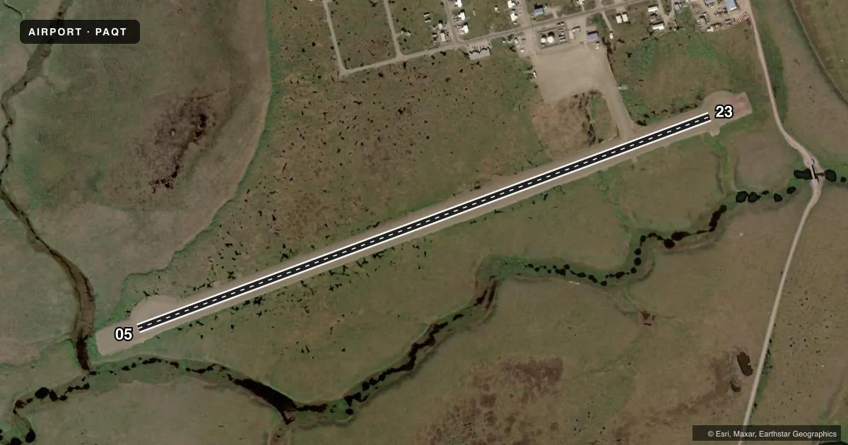
Runways & pattern
Full pagePattern entry · RWY 05
RIGHT TRAFFICRunway end performance
| End | TORA | TODA | ASDA | LDA | VGSI | Approach lights | Obstruction |
|---|---|---|---|---|---|---|---|
| 05 | — | — | — | — | PAPI 2-box left(3°) | MALSF | — |
| 23 | — | — | — | — | PAPI 2-box left(3°) | — | — |
Declared distances in feet. TORA = takeoff run available, TODA = takeoff distance, ASDA = accelerate-stop, LDA = landing distance.
Airport sketch
Runways drawn to scale from FAA survey coordinates, rendered over satellite imagery. Not for navigation.
Approaches & charts
Services on the field
Fuel grades, oxygen, maintenance, ramp storage and lighting — as declared to the FAA by the airport operator.
Fuel & services
- Fuel
- Not available
Ramp & ground
- Transient storage
- Not published
- Landing fee
- No fee published
- Lighting schedule
- SEE RMK
- Beacon schedule
- SS-SR
- Beacon
- White / Green (civil land)(WG)
- Wind indicator
- Lighted
- Segmented circle
- Yes
Fuel & FBOs
Cheapest 100LL and Jet A on the field and nearby. Always confirm with the FBO before taxi.
Airport notes
Surface conditions, obstructions, local procedures, lighting outages and other notes published with each FAA cycle.
General notes
- BIRDS & CARIBOU ON & INVOF ARPT.
- RWY COND UNMNT; RCMD VISUAL INSP PRIOR TO LNDG.
- DEADHORSE FSS LCL - 907 659-2401; FAIRBANKS FSS - 1-866-248-6516.
- WX CAMERA AVBL ON INTERNET AT HTTPS://WEATHERCAMS.FAA.GOV.
Lighting notes
- ACTVT MALSF RWY 05, REIL RWY 23; PAPI RWY 05, 23; MIRL RWY 05/23 - CTAF.
Approach & departure obstructions
- 23100 FT LGTD TWR 847 FT N OF THR.
Other notes
- AIRSPACE DETERMINATION PENDING.
- MANAGEREXT 342
VFR map & nearby airports
VFR sectional. Tap any ICAO chip to open that airport.
Key facts · PAQT
Answer card- ICAO
- PAQT
- Name
- NUIQSUT
- Location
- NUIQSUT, ALASKA
- Elevation
- 45.4 ft MSL
- Traffic pattern altitude
- 1,045.4 ft MSL (1,000 AGL)
- Control tower
- Non-towered (use CTAF)
- Total runways
- 1
- Longest runway
- 05/23 · 4,589 ft
- Published ILS approaches
- 0
- Published frequencies
- 1
- Magnetic variation
- 21°
- Current flight rules
- VFR
- Current wind
- 010° at 6 kt
- Favored runway now
- RWY 05
Nuiqsut Airport sits in Nuiqsut, Alaska at 45.4 ft MSL. It has one runway. Runway 05/23 is 4,589 ft of gravel, which is the longest runway on the field. There is no control tower. Use CTAF 122.8 for traffic calls.
No ILS approaches are published here. The published lighting is useful for night work. MALSF is active on runway 05. REIL is on runway 23. PAPI is available on both ends. Medium intensity runway lighting is also available on 05 and 23. The runway condition is unmonitored, so a visual inspection before landing is a good idea.
Pattern altitude is not published. Use caution with local traffic and verify the current pattern altitude before arrival. Airspace determination is pending, so check the current FAA Chart Supplement or the current sectional before you go. Birds and caribou are present on and near the airport. There is also a 100-foot lighted tower 847 feet north of the runway 23 threshold. No on-field FBOs are listed, so contact the airport operator directly or call the field for current fuel and service availability. The manager phone extension is 342. For flight service, use Deadhorse FSS at 907 659-2401 or Fairbanks FSS at 1-866-248-6516.