METAR & TAF PAGB
Current METAR
Observed 19:30Z
PAGB 241930Z 29005KT 10SM FEW040 19/ A2989
- Wind
- 290° @ 5 kt
- Visibility
- 10 SM
- Temp / Dew
- —
- Altimeter
- 29.89 inHg
- Clouds
- FEW
- Density alt
- —
- Ceiling
- Unlimited
- Rules
- VFR
Airport info & contacts
Manager on record, flight service, ARTCC, attendance schedule and pattern altitude — published by the FAA and refreshed every 28 days.
Location
- From city
- 2 NM N
- VFR sectional
- POINT BARROW
- ARTCC
- ZAN · ANCHORAGE
- NOTAM facility
- GBH (NOTAM-D)
Airport manager
- Name
- RENIER SWART
- Phone
- 907-787-8959
- Address
- P.O. BOX 196660, MS 530B, ANCHORAGE AK 99512
Flight service · Hours
- FSS FAI
- FAIRBANKS907-474-07881-866-248-6516
- Attendance
- Unattended
Frequencies
Tap any row to copy the frequency to your clipboard.
Runways & pattern
Full pagePattern entry · RWY 32
LEFT TRAFFICRunway end performance
| End | TORA | TODA | ASDA | LDA | VGSI | Approach lights | Obstruction |
|---|---|---|---|---|---|---|---|
| 14 | — | — | — | — | PAPI 2-box left(3°) | ODALS | — |
| 32 | — | — | — | — | PAPI 2-box left(4°) | — | 15', road, 0' from thr, 80' R of cntrln, slope 0 |
Declared distances in feet. TORA = takeoff run available, TODA = takeoff distance, ASDA = accelerate-stop, LDA = landing distance.
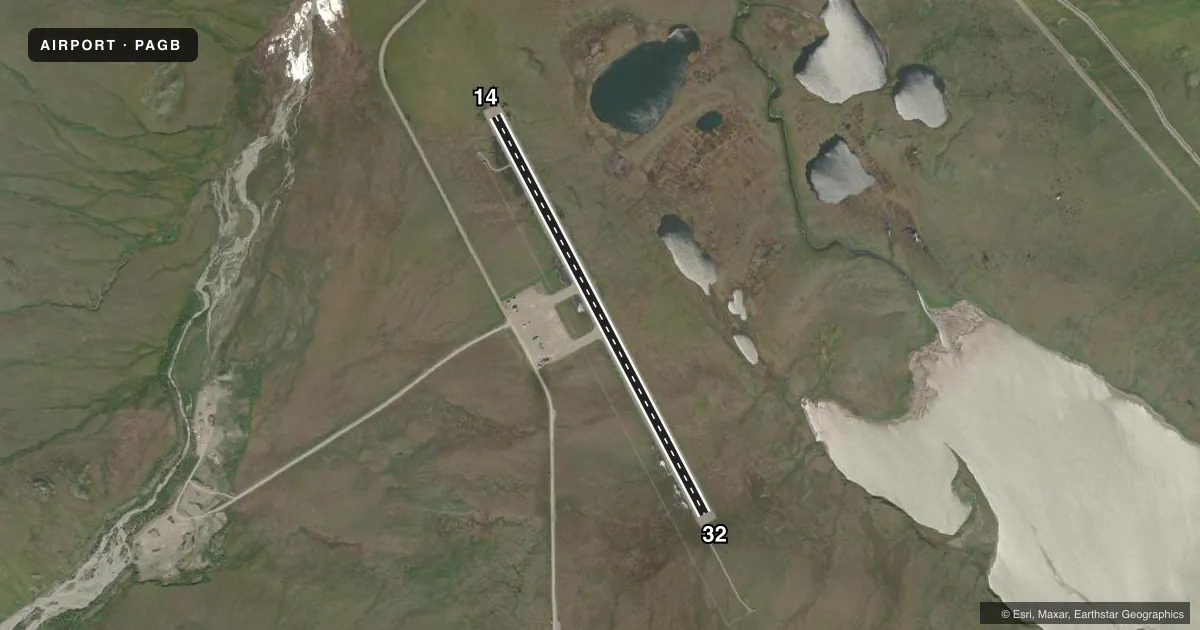
Airport sketch
Runways drawn to scale from FAA survey coordinates, rendered over satellite imagery. Not for navigation.
Approaches & charts
Services on the field
Fuel grades, oxygen, maintenance, ramp storage and lighting — as declared to the FAA by the airport operator.
Fuel & services
- Fuel
- Not available
Ramp & ground
- Transient storage
- Not published
- Landing fee
- No fee published
- Lighting schedule
- SEE RMK
- Beacon schedule
- SS-SR
- Beacon
- White / Green (civil land)(WG)
- Wind indicator
- Lighted
- Segmented circle
- Yes
Fuel & FBOs
Cheapest 100LL and Jet A on the field and nearby. Always confirm with the FBO before taxi.
Airport notes
Surface conditions, obstructions, local procedures, lighting outages and other notes published with each FAA cycle.
General notes
- COLD TEMPERATURE AIRPORT. ALTITUDE CORRECTION REQUIRED AT OR BELOW -32C.
- LMTD SNOW REMOVAL.
Lighting notes
- ACTVT ODALS RWY 14; PAPI RWY 14 & 32 - CTAF.
Runway surface & condition
- 14/32100 FT OVERRUNS.
Other notes
- MANAGER907-787-4402/4405.
- 14/32COND UNMNT; RCMD VISUAL INSP PRIOR TO USE.
VFR map & nearby airports
VFR sectional. Tap any ICAO chip to open that airport.
Key facts · PAGB
Answer card- ICAO
- PAGB
- Name
- GALBRAITH LAKE
- Location
- GALBRAITH LAKE, ALASKA
- Elevation
- 2,662.7 ft MSL
- Traffic pattern altitude
- 3,662.7 ft MSL (1,000 AGL)
- Control tower
- Non-towered (use CTAF)
- Total runways
- 1
- Longest runway
- 14/32 · 5,182 ft
- Published ILS approaches
- 0
- Published frequencies
- 1
- Magnetic variation
- 16°
- Current flight rules
- VFR
- Current wind
- 290° at 5 kt
- Favored runway now
- RWY 32
Galbraith Lake Airport (PAGB) sits at Galbraith Lake in Alaska. Field elevation is 2,662.7 ft MSL. The airport has one runway. Runway 14/32 is 5,182 ft long and gravel. The airport is not towered. CTAF is 122.9.
No ILS approaches are published here. The published pattern altitude is not given, so use the current Chart Supplement before you fly. The runway headings are 152° and 332° magnetic. Published remarks note an omnidirectional approach lighting system on runway 14. PAPI is available on runways 14 and 32. It is controlled by CTAF. The field also has 100-foot overruns.
This is a cold temperature airport. Altitude correction is required at or below minus 32 degrees Celsius. Limited snow removal is available. The runway surface condition is unmaintained, so a visual inspection before use is a good idea. There are no on-field FBOs listed. Contact the airport operator directly or the FBO directly by phone for current services before arrival. For a first-time arrival, plan for gravel surface operations, cold-weather performance and reduced winter support. Check the current Chart Supplement for any local operating notes before you go.