METAR & TAF PASC
Current METAR
Observed 21:53Z
PASC 272153Z 02009KT 10SM FEW007 SCT022 OVC030 03/00 A3006 RMK AO2 SLP181 T00330000 $
- Wind
- 020° @ 9 kt
- Visibility
- 10 SM
- Temp / Dew
- 3°C / 0°C
- Altimeter
- 30.06 inHg
- Clouds
- OVC
- Density alt
- -1,530 ft
- Ceiling
- 3,000 ft AGL
- Rules
- MVFR
Airport info & contacts
Manager on record, flight service, ARTCC, attendance schedule and pattern altitude — published by the FAA and refreshed every 28 days.
Location
- From city
- 0 NM SE
- VFR sectional
- POINT BARROW
- ARTCC
- ZAN · ANCHORAGE
- NOTAM facility
- SCC (NOTAM-D)
Airport manager
- Name
- TIM PARAULT
- Phone
- 907-328-7130
- Address
- POUCH 340002, PRUDHOE BAY AK 99734
Flight service · Hours
- FSS SCC
- DEADHORSE907-659-2401LC659-2401
- Attendance
- 0600-1830
Frequencies
Tap any row to copy the frequency to your clipboard.
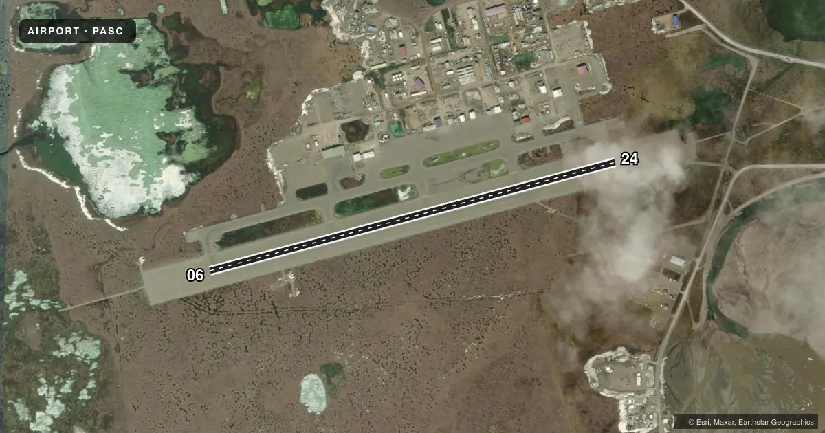
Runways & pattern
Full pagePattern entry · RWY 06
RIGHT TRAFFICRunway end performance
| End | TORA | TODA | ASDA | LDA | VGSI | Approach lights | Obstruction |
|---|---|---|---|---|---|---|---|
| 06 | 6,500' | 6,500' | 6,500' | 6,500' | VASI 4-box left(3°) | MALSR | — |
| 24 | 6,500' | 6,500' | 6,500' | 6,500' | VASI 4-box left(3°) | MALSR | — |
Declared distances in feet. TORA = takeoff run available, TODA = takeoff distance, ASDA = accelerate-stop, LDA = landing distance.
Airport sketch
Runways drawn to scale from FAA survey coordinates, rendered over satellite imagery. Not for navigation.
Approaches & charts
ILS · 1
Services on the field
Fuel grades, oxygen, maintenance, ramp storage and lighting — as declared to the FAA by the airport operator.
Fuel & services
- Fuel
- 100A
- Other services
- CARGO
Ramp & ground
- Transient storage
- Not published
- Landing fee
- No fee published
- Customs
- Not available
- Lighting schedule
- SEE RMK
- Beacon schedule
- SS-SR
- Beacon
- White / Green (civil land)(WG)
- Wind indicator
- Lighted
- Segmented circle
- Yes
Fuel & FBOs
Cheapest 100LL and Jet A on the field and nearby. Always confirm with the FBO before taxi.
Airport notes
Surface conditions, obstructions, local procedures, lighting outages and other notes published with each FAA cycle.
General notes
- WATERFOWL INVOF ARPT; CARIBOU ON RWY & MOV AREAS.
- WX OBS WHEN DEADHORSE FSS CLSD - 133.55 OR 907-659-2401.
- ARPT MAINT 0600-1830; AFT HR - AMGR.
- WX CAMERA AVBL ON INTERNET AT HTTPS://WEATHERCAMS.FAA.GOV
- ARFF SVC PPR IN WRITING - AMGR.
- AVN CNTR PVT PPR - 907-538-3600.
- TSA REGULATED; SEE 49 CFR 1542. ALL GATES & DOORS MUST BE SECURED AT ALL TIMES. TSNT OR UNFAMILIAR PILOTS - AMGR FOR INFO.
- COLVILLE RAMP CLSD.
Lighting notes
- WHEN FSS CLSD ACVT MALSR RWY 06 & 24; HIRL RWY 06/24 - CTAF. HIRL RWY 06/24 PRESET LOW INTST; INCR INTST - CTAF.
Fuel notes
- A0600-1800 - 122.85 OR 907-659-6215.
Runway surface & condition
- 06/24PCR VALUE: 801/F/A/X/T
Other notes
- CLSD TO ACR OPS MORE THAN 30 PAX SEATS EXC PPR IN WRITING - AMGR PO BOX 340002 PRUDHOE BAY AK 99734.
VFR map & nearby airports
VFR sectional. Tap any ICAO chip to open that airport.
Key facts · PASC
Answer card- ICAO
- PASC
- Name
- DEADHORSE
- Location
- DEADHORSE, ALASKA
- Elevation
- 67.4 ft MSL
- Traffic pattern altitude
- 1,067.4 ft MSL (1,000 AGL)
- Control tower
- Non-towered (use CTAF)
- Total runways
- 1
- Longest runway
- 06/24 · 6,500 ft
- Published ILS approaches
- 1
- Published frequencies
- 2
- Magnetic variation
- 17°
- Current flight rules
- MVFR
- Current wind
- 020° at 9 kt
- Favored runway now
- RWY 06
Deadhorse Airport sits in Deadhorse, Alaska. Field elevation is 67.4 ft MSL. The airport has one runway. Runway 06/24 is 6,500 ft asphalt. The runway headings are 75° and 255° magnetic. There is one ILS approach. It serves runway 06. The field is not towered. UNICOM is 123.0. CTAF is 123.6.
Pattern altitude is not published. For light piston operations, use 1,000 ft AGL unless the current Chart Supplement says otherwise. That puts the pattern at about 1,067 ft MSL based on the listed field elevation. Colville is the on-field FBO. It carries 100LL and Jet A. Fuel service is listed from 0600 to 1800 on 122.85 or by phone at (907) 659-6215. The ramp for Colville is closed, so plan ahead with the airport operator or the FBO directly.
This is an Alaska field with real operational issues. The airport is TSA regulated. Gates and doors must stay secured. Waterfowl are reported near the airport. Caribou are on the runway and movement areas. The airport also has lighting procedures that matter after hours. When the FSS is closed, use the medium intensity approach lighting system with runway alignment indicator lights for 06 and 24. High intensity runway lights for 06/24 are controlled by CTAF. If you are new to the field, verify current procedures with the airport operator before arrival.