METAR & TAF RK1
RK1 does not publish a METAR.
Showing the nearest reporting station: PASC (DEADHORSE) · 44.8 NM away. Conditions at RK1 may differ.
METAR · PASC
Observed 00:31Z
PASC 280031Z AUTO 01010KT 10SM SCT011 OVC030 03/01 A3008
- Wind
- 010° @ 10 kt
- Visibility
- 10 SM
- Temp / Dew
- 3°C / 1°C
- Altimeter
- 30.08 inHg
- Clouds
- OVC
- Density alt
- -810 ft
- Ceiling
- 3,000 ft AGL
- Rules
- MVFR
Airport info & contacts
Manager on record, flight service, ARTCC, attendance schedule and pattern altitude — published by the FAA and refreshed every 28 days.
Location
- From city
- 60 NM W
- VFR sectional
- POINT BARROW
- ARTCC
- ZAN · ANCHORAGE
- NOTAM facility
- SCC
Airport manager
- Name
- SUSAN AIKENS
- Phone
- 404-857-4707
- Address
- 3875 GEIST RD, STE E 267, FAIRBANKS AK 99709
Flight service · Hours
- FSS SCC
- DEADHORSE907-659-2401LC659-2401
- Attendance
- ALL
Frequencies
Tap any row to copy the frequency to your clipboard.
Runways & pattern
Full pagePattern entry · RWY 26
LEFT TRAFFICRunway end performance
| End | TORA | TODA | ASDA | LDA | VGSI | Approach lights | Obstruction |
|---|---|---|---|---|---|---|---|
| 08 | — | — | — | — | — | — | 15', road, 0' from thr, 0' R of cntrln, slope 0 |
| 26 | — | — | — | — | — | — | 7', brush, 0' from thr, 61' R of cntrln, slope 0 |
Declared distances in feet. TORA = takeoff run available, TODA = takeoff distance, ASDA = accelerate-stop, LDA = landing distance.
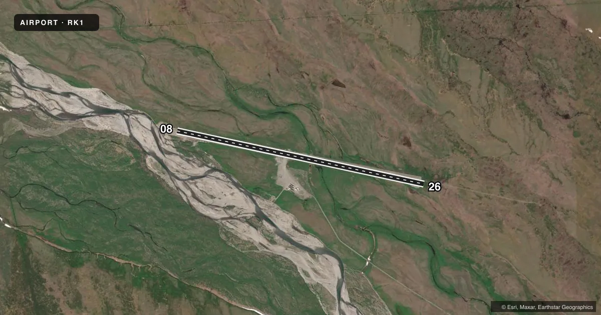
Airport sketch
Runways drawn to scale from FAA survey coordinates, rendered over satellite imagery. Not for navigation.
Approaches & charts
Services on the field
Fuel grades, oxygen, maintenance, ramp storage and lighting — as declared to the FAA by the airport operator.
Fuel & services
- Fuel
- 100LLA
Ramp & ground
- Transient storage
- Not published
- Wind indicator
- Yes
- Segmented circle
- No
Fuel & FBOs
Cheapest 100LL and Jet A on the field and nearby. Always confirm with the FBO before taxi.
Airport notes
Surface conditions, obstructions, local procedures, lighting outages and other notes published with each FAA cycle.
Approach & departure obstructions
- 08RWY 08 THR MARKERS NON STANDARD, BARRELS AND REFLECTIVE CONES.
- 26RWY THR MARKERS NON STANDARD; REFLECTIVE CONE.
Other notes
- 08/26RWY SFC IS LOOSE GRVL AND ROCKS, MID SECTION OF RWY IS FAIRLY SMOOTH, FIRST 1500 FT OF BOTH RWY ENDS ARE ROUGH DUE TO FROST HEAVES.
VFR map & nearby airports
VFR sectional. Tap any ICAO chip to open that airport.
Key facts · RK1
Answer card- ICAO
- RK1
- Name
- KAVIK STRIP
- Location
- KAVIK RIVER, ALASKA
- Elevation
- 668 ft MSL
- Traffic pattern altitude
- 1,668 ft MSL (1,000 AGL)
- Control tower
- Non-towered (use CTAF)
- Total runways
- 1
- Longest runway
- 08/26 · 5,500 ft
- Published ILS approaches
- 0
- Published frequencies
- 1
- Magnetic variation
- –
- Current flight rules
- MVFR
- Current wind
- 010° at 10 kt
- Favored runway now
- RWY 26
Kavik Strip sits at Kavik River, Alaska. Field elevation is 668 ft MSL. This is a single-runway strip with runway 08/26 at 5,500 ft. There is no control tower. CTAF is 122.9. No ILS approaches are published.
The published pattern altitude is not listed. Use standard 1,000 ft AGL for light piston operations unless the current FAA Chart Supplement says otherwise. The runway is gravel and dirt. The published remarks say the surface is loose gravel and rocks. The middle of the runway is fairly smooth. The first 1,500 ft of both ends are rough from frost heaves. Threshold marking is also nonstandard. Runway 08 uses barrels and reflective cones. Runway 26 uses reflective cones.
There are no on-field FBOs listed. Plan on self-sufficiency. Verify current services with the airport operator before you go. For a first trip, the big items are surface condition, rough ends and the lack of published instrument approaches. This is a remote Alaska strip, so weather and visibility matter a lot. Check the current FAA Chart Supplement for any additional local notes before departure.