METAR & TAF PARC
Current METAR
Observed 04:56Z
PARC 280456Z AUTO 07008KT 10SM OVC100 18/08 A2980 RMK AO2 SLP108 T01780083 TSNO
- Wind
- 070° @ 8 kt
- Visibility
- 10 SM
- Temp / Dew
- 18°C / 8°C
- Altimeter
- 29.80 inHg
- Clouds
- OVC
- Density alt
- 3,103 ft
- Ceiling
- 10,000 ft AGL
- Rules
- VFR
Airport info & contacts
Manager on record, flight service, ARTCC, attendance schedule and pattern altitude — published by the FAA and refreshed every 28 days.
Location
- From city
- 1 NM SW
- VFR sectional
- POINT BARROW
- ARTCC
- ZAN · ANCHORAGE
- NOTAM facility
- ARC
Airport manager
- Name
- JONATHAN JOHNS
- Phone
- 907-587-5523
- Address
- P.O. BOX 69, ARCTIC VILLAGE AK 99722
Flight service · Hours
- FSS FAI
- FAIRBANKS907-474-07881-866-248-6516
- Attendance
- Unattended
Frequencies
Tap any row to copy the frequency to your clipboard.
Runways & pattern
Full pagePattern entry · RWY 02
LEFT TRAFFICRunway end performance
| End | TORA | TODA | ASDA | LDA | VGSI | Approach lights | Obstruction |
|---|---|---|---|---|---|---|---|
| 20 | — | — | — | — | PAPI 4-box left(3°) | — | 15', road, 337' from thr, 300' R of cntrln, slope 22 |
Declared distances in feet. TORA = takeoff run available, TODA = takeoff distance, ASDA = accelerate-stop, LDA = landing distance.
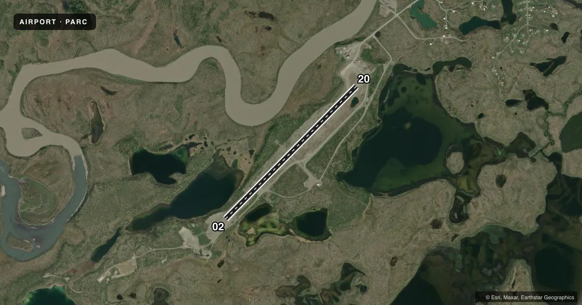
Airport sketch
Runways drawn to scale from FAA survey coordinates, rendered over satellite imagery. Not for navigation.
Approaches & charts
Services on the field
Fuel grades, oxygen, maintenance, ramp storage and lighting — as declared to the FAA by the airport operator.
Fuel & services
- Fuel
- Not available
Ramp & ground
- Transient storage
- Not published
- Landing fee
- Yes
- Lighting schedule
- SEE RMK
- Beacon schedule
- SEE RMK
- Beacon
- White / Green (civil land)(WG)
- Wind indicator
- Lighted
- Segmented circle
- Yes
Fuel & FBOs
Cheapest 100LL and Jet A on the field and nearby. Always confirm with the FBO before taxi.
Airport notes
Surface conditions, obstructions, local procedures, lighting outages and other notes published with each FAA cycle.
General notes
- WX CAMERA AVBL ON INTERNET AT HTTPS://WEATHERCAMS.FAA.GOV/.
- COLD TEMPERATURE AIRPORT. ALTITUDE CORRECTION REQUIRED AT OR BELOW -37C.
- RWY SLPS DOWNHILL TO SW.
- RWY UNMNT RCMND VISUAL INSP PRIOR TO LDG.
Lighting notes
- OTS INDEFLY.
- DUSK-DAWN.
- DUSK-DAWN: ACTVT REIL RWY 20, PAPI RWY 20; MIRL RWY 02/20 - CTAF.
Runway surface & condition
- 02/20LINE OF SIGHT BTN RWY ENDS NA.
VFR map & nearby airports
VFR sectional. Tap any ICAO chip to open that airport.
Key facts · PARC
Answer card- ICAO
- PARC
- Name
- ARCTIC VILLAGE
- Location
- ARCTIC VILLAGE, ALASKA
- Elevation
- 2,092 ft MSL
- Traffic pattern altitude
- 3,092 ft MSL (1,000 AGL)
- Control tower
- Non-towered (use CTAF)
- Total runways
- 1
- Longest runway
- 02/20 · 4,500 ft
- Published ILS approaches
- 0
- Published frequencies
- 1
- Magnetic variation
- 26°
- Current flight rules
- VFR
- Current wind
- 070° at 8 kt
- Favored runway now
- RWY 02
Arctic Village Airport sits in Arctic Village, Alaska. The field elevation is 2,092 ft MSL. It has one runway, 02/20, which is 4,500 ft long and gravel. There is no control tower. CTAF is 122.9. No ILS approaches are published here.
The pattern altitude is not published. Use standard 1,000 ft AGL for light piston operations unless the current Chart Supplement or local procedures say otherwise. The runway is unmaintained, so a visual inspection before landing is a good idea. The runway also slopes downhill to the southwest. Line of sight between runway ends is not available, so plan your traffic calls carefully. Lighting is available from dusk to dawn. Runway end identifier lights for runway 20 are activated from dusk to dawn. Medium intensity runway lights for runways 02 and 20 are controlled on CTAF.
There are no on-field FBOs listed. Check with the airport operator or the FBO directly by phone before arrival if you need local services. The beacon is out of service indefinitely. This is also a cold temperature airport. Altitude correction is required at or below minus 37 degrees Celsius. A weather camera is available through the FAA weather camera system.