METAR & TAF PAAR
PAAR does not publish a METAR.
Showing the nearest reporting station: PFYU (FORT YUKON) · 22.6 NM away. Conditions at PAAR may differ.
METAR · PFYU
Observed 15:56Z
PFYU 271556Z 03007KT 10SM FEW031 BKN095 18/13 A2976
- Wind
- 030° @ 7 kt
- Visibility
- 10 SM
- Temp / Dew
- 18°C / 13°C
- Altimeter
- 29.76 inHg
- Clouds
- BKN
- Density alt
- 1,104 ft
- Ceiling
- 9,500 ft AGL
- Rules
- VFR
Airport info & contacts
Manager on record, flight service, ARTCC, attendance schedule and pattern altitude — published by the FAA and refreshed every 28 days.
Location
- From city
- 1 NM NNW
- VFR sectional
- FAIRBANKS
- ARTCC
- ZAN · ANCHORAGE
- NOTAM facility
- FAI
Airport manager
- Name
- JASON LUDINGTON
- Phone
- (907) 451-5280
- Address
- 2301 PEGER RD, FAIRBANKS AK 99709
Flight service · Hours
- FSS FAI
- FAIRBANKS907-474-07881-866-248-6516
- Attendance
- Unattended
Frequencies
Tap any row to copy the frequency to your clipboard.
Runways & pattern
Full pagePattern entry · RWY 34
LEFT TRAFFICRunway end performance
| End | TORA | TODA | ASDA | LDA | VGSI | Approach lights | Obstruction |
|---|---|---|---|---|---|---|---|
| 16 | — | — | — | — | — | — | 4', brush, 105' from thr, 80' R of cntrln, slope 26 |
| 34 | — | — | — | — | — | — | 6', trees, 0' from thr, 125' R of cntrln, slope 1 |
Declared distances in feet. TORA = takeoff run available, TODA = takeoff distance, ASDA = accelerate-stop, LDA = landing distance.
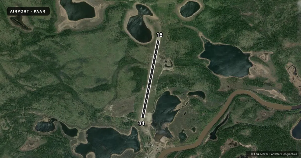
Airport sketch
Runways drawn to scale from FAA survey coordinates, rendered over satellite imagery. Not for navigation.
Approaches & charts
Services on the field
Fuel grades, oxygen, maintenance, ramp storage and lighting — as declared to the FAA by the airport operator.
Fuel & services
- Fuel
- Not available
Ramp & ground
- Transient storage
- Tie-down
- Lighting schedule
- SEE RMK
- Beacon schedule
- SS-SR
- Beacon
- White / Green (civil land)(WG)
- Wind indicator
- Lighted
- Segmented circle
- Yes
Fuel & FBOs
Cheapest 100LL and Jet A on the field and nearby. Always confirm with the FBO before taxi.
Airport notes
Surface conditions, obstructions, local procedures, lighting outages and other notes published with each FAA cycle.
General notes
- SNOW REMOVAL OPS - CTAF.
- RWY COND UNMNT; RCMD VISUAL INSP PRIOR TO LNDG.
- SUAIS - 125.3, 1-800-758-8723.
Lighting notes
- ACTVT MIRL RWY 16/34 - CTAF.
VFR map & nearby airports
VFR sectional. Tap any ICAO chip to open that airport.
Key facts · PAAR
Answer card- ICAO
- PAAR
- Name
- BIRCH CREEK
- Location
- BIRCH CREEK, ALASKA
- Elevation
- 439.8 ft MSL
- Traffic pattern altitude
- 1,439.8 ft MSL (1,000 AGL)
- Control tower
- Non-towered (use CTAF)
- Total runways
- 1
- Longest runway
- 16/34 · 4,000 ft
- Published ILS approaches
- 0
- Published frequencies
- 1
- Magnetic variation
- 16°
- Current flight rules
- VFR
- Current wind
- 030° at 7 kt
- Favored runway now
- RWY 34
Birch Creek Airport sits in Birch Creek, Alaska. Field elevation is 439.8 ft MSL. The airport has one runway. Runway 16/34 is 4,000 ft long and gravel. There is no control tower. CTAF is 122.9.
No ILS approaches are published here. Pattern altitude is not published, so use the standard 1,000 ft AGL for light piston traffic unless the current Chart Supplement says otherwise. With a field elevation of 439.8 ft MSL, that puts the standard pattern at about 1,439.8 ft MSL for light piston aircraft. The runway lighting on 16/34 is medium intensity. It is activated by the CTAF. Runway condition is unmonitored, so a visual check before landing is smart. Snow removal operations are also conducted on the CTAF.
There are no on-field FBOs listed. Check with the airport operator or call the field on CTAF for current services before you go. Special use airspace information is available on frequency 125.3 or by calling 1-800-758-8723. This is a gravel strip in Alaska, so plan for seasonal surface changes, winter ops and local conditions that can change fast.