METAR & TAF PACE
PACE does not publish a METAR.
Showing the nearest reporting station: PFYU (FORT YUKON) · 61.0 NM away. Conditions at PACE may differ.
METAR · PFYU
Observed 12:56Z
PFYU 271256Z AUTO VRB05KT 10SM OVC021 08/05 A2972
- Wind
- VAR @ 5 kt
- Visibility
- 10 SM
- Temp / Dew
- 8°C / 5°C
- Altimeter
- 29.72 inHg
- Clouds
- OVC
- Density alt
- 570 ft
- Ceiling
- 2,100 ft AGL
- Rules
- MVFR
Airport info & contacts
Manager on record, flight service, ARTCC, attendance schedule and pattern altitude — published by the FAA and refreshed every 28 days.
Location
- From city
- 0 NM NNE
- VFR sectional
- DAWSON
- ARTCC
- ZAN · ANCHORAGE
- NOTAM facility
- FAI (NOTAM-D)
Airport manager
- Name
- JASON LUDINGTON
- Phone
- 907-451-5280
- Address
- 2301 PEGER ROAD, FAIRBANKS AK 99709
Flight service · Hours
- FSS FAI
- FAIRBANKS907-474-07881-866-248-6516
- Attendance
- Unattended
Frequencies
Tap any row to copy the frequency to your clipboard.
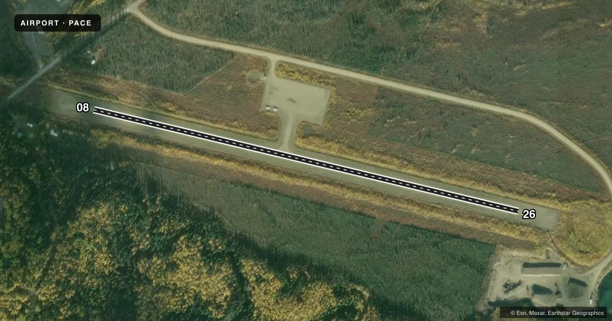
Runways & pattern
Full pagePattern entry · RWY 26
LEFT TRAFFICRunway end performance
| End | TORA | TODA | ASDA | LDA | VGSI | Approach lights | Obstruction |
|---|---|---|---|---|---|---|---|
| 08 | — | — | — | — | — | — | 5', brush, 0' from thr, 80' R of cntrln, slope 0 |
| 26 | — | — | — | — | — | — | 2', brush, 0' from thr, 100' R of cntrln, slope 0 |
Declared distances in feet. TORA = takeoff run available, TODA = takeoff distance, ASDA = accelerate-stop, LDA = landing distance.
Airport sketch
Runways drawn to scale from FAA survey coordinates, rendered over satellite imagery. Not for navigation.
Approaches & charts
Services on the field
Fuel grades, oxygen, maintenance, ramp storage and lighting — as declared to the FAA by the airport operator.
Fuel & services
- Fuel
- Not available
Ramp & ground
- Transient storage
- Tie-down
- Lighting schedule
- SEE RMK
- Beacon schedule
- SS-SR
- Beacon
- White / Green (civil land)(WG)
- Wind indicator
- Lighted
- Segmented circle
- Yes
Fuel & FBOs
Cheapest 100LL and Jet A on the field and nearby. Always confirm with the FBO before taxi.
Airport notes
Surface conditions, obstructions, local procedures, lighting outages and other notes published with each FAA cycle.
General notes
- RWY COND UNMNT; RCMD VISUAL INSP BFR LNDG.
- SNOW REMOVAL MNT CTAF.
- SUAIS - 125.3/126.3; 1-800-758-8723.
- WX CAMERA AVBL ON INTERNET AT HTTPS://WEATHERCAMS.FAA.GOV
Lighting notes
- ACTVT MIRL RWY 08/26 - CTAF.
Approach & departure obstructions
- 08DTHR MKD WITH BLUE LGTS & REFLECTORS.
Other notes
- THIS AIRPORT HAS BEEN SURVEYED BY THE NATIONAL GEODETIC SURVEY.
- 08/2612 IN SFC GRASS.
VFR map & nearby airports
VFR sectional. Tap any ICAO chip to open that airport.
Key facts · PACE
Answer card- ICAO
- PACE
- Name
- CENTRAL
- Location
- CENTRAL, ALASKA
- Elevation
- 936.8 ft MSL
- Traffic pattern altitude
- 1,936.8 ft MSL (1,000 AGL)
- Control tower
- Non-towered (use CTAF)
- Total runways
- 1
- Longest runway
- 08/26 · 2,782 ft
- Published ILS approaches
- 0
- Published frequencies
- 1
- Magnetic variation
- 20°
- Current flight rules
- MVFR
- Current wind
- 000° at 5 kt
- Favored runway now
- RWY 26
Central Airport (PACE) sits in Central, Alaska at 936.8 ft MSL. It has one runway. Runway 08/26 is 2,782 ft long with a gravel-dirt surface. The published headings are 103° and 283° magnetic. There is no control tower. CTAF is 122.9.
No ILS approaches are published here. Pattern altitude is not published, so a light piston pilot should plan on the standard 1,000 ft AGL unless the current FAA Chart Supplement says otherwise. The field has no on-field FBOs listed. Fuel availability needs a direct check with the airport operator or the FBO directly by phone before arrival.
A few published remarks matter here. Runway condition is unmonitored, so a visual inspection before landing is smart. Snow removal is monitored on CTAF. Medium intensity runway lights on 08/26 are activated by CTAF. The displaced threshold on runway 08 is marked with blue lights and reflectors. The airport also has a weather camera on the FAA site. This is a remote Alaska strip with a gravel-dirt surface, so plan for surface condition, seasonal snow and reduced braking margin. Special use airspace information is available on 125.3 or 126.3, or by calling the published number before you go.