METAR & TAF CHP
CHP does not publish a METAR.
Showing the nearest reporting station: PFYU (FORT YUKON) · 67.0 NM away. Conditions at CHP may differ.
METAR · PFYU
Observed 11:56Z
PFYU 271156Z AUTO 00000KT 10SM OVC085 17/13 A2975
- Wind
- 000° @ 0 kt
- Visibility
- 10 SM
- Temp / Dew
- 17°C / 13°C
- Altimeter
- 29.75 inHg
- Clouds
- OVC
- Density alt
- 1,530 ft
- Ceiling
- 8,500 ft AGL
- Rules
- VFR
Airport info & contacts
Manager on record, flight service, ARTCC, attendance schedule and pattern altitude — published by the FAA and refreshed every 28 days.
Location
- From city
- 1 NM E
- VFR sectional
- DAWSON
- ARTCC
- ZAN · ANCHORAGE
- NOTAM facility
- FAI (NOTAM-D)
Airport manager
- Name
- JASON LUDINGTON
- Phone
- 907-451-5280
- Address
- 2301 PEGER RD, FAIRBANKS AK 99709
Flight service · Hours
- FSS FAI
- FAIRBANKS907-474-07881-866-248-6516
- Attendance
- Unattended
Frequencies
Tap any row to copy the frequency to your clipboard.
Runways & pattern
Full pagePattern entry · RWY 09
LEFT TRAFFICRunway end performance
| End | TORA | TODA | ASDA | LDA | VGSI | Approach lights | Obstruction |
|---|---|---|---|---|---|---|---|
| 09 | — | — | — | — | — | — | 5', brush, 0' from thr, 70' R of cntrln, slope 0 |
| 27 | — | — | — | — | — | — | 7', brush, 0' from thr, 80' R of cntrln, slope 0 |
Declared distances in feet. TORA = takeoff run available, TODA = takeoff distance, ASDA = accelerate-stop, LDA = landing distance.
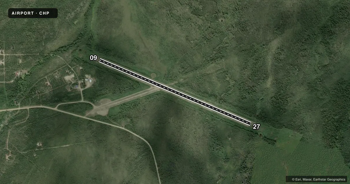
Airport sketch
Runways drawn to scale from FAA survey coordinates, rendered over satellite imagery. Not for navigation.
Approaches & charts
Services on the field
Fuel grades, oxygen, maintenance, ramp storage and lighting — as declared to the FAA by the airport operator.
Fuel & services
- Fuel
- Not available
Ramp & ground
- Transient storage
- Tie-down
- Landing fee
- No fee published
- Customs
- Not available
- Wind indicator
- Lighted
- Segmented circle
- Yes
Fuel & FBOs
Cheapest 100LL and Jet A on the field and nearby. Always confirm with the FBO before taxi.
Airport notes
Surface conditions, obstructions, local procedures, lighting outages and other notes published with each FAA cycle.
General notes
- PSBL SUMMER RETARDANT ACFT OPS.
- RWY MAINT & SNOW REMOVAL NA. RWY COND UNMNT; RCMD VISUAL INSP BFR LNDG.
- SUAIS - 125.3/126.3 - 1-800-758-8723.
- WX CAMERA AVBL ON INTERNET AT HTTPS://WEATHERCAMS.FAA.GOV
Approach & departure obstructions
- 27FIRST 1000 FT UNUSBL; SFC HEAVES & 10 FT BRUSH ON RWY.
- 09RISING TRRN SE.
- 27RISING TRRN SW.
VFR map & nearby airports
VFR sectional. Tap any ICAO chip to open that airport.
Key facts · CHP
Answer card- ICAO
- CHP
- Name
- CIRCLE HOT SPRINGS
- Location
- CIRCLE HOT SPRINGS, ALASKA
- Elevation
- 870.2 ft MSL
- Traffic pattern altitude
- 1,870.2 ft MSL (1,000 AGL)
- Control tower
- Non-towered (use CTAF)
- Total runways
- 1
- Longest runway
- 09/27 · 3,669 ft
- Published ILS approaches
- 0
- Published frequencies
- 1
- Magnetic variation
- 30°
- Current flight rules
- VFR
- Current wind
- 000° at 0 kt
- Favored runway now
- –
Circle Hot Springs Airport sits in Circle Hot Springs, Alaska. Field elevation is 870.2 ft MSL. The airport has one runway. Runway 09/27 is 3,669 ft long and surfaced with gravel. There is no control tower. CTAF is 122.8.
No ILS approaches are published here. Pattern altitude is not published, so use the standard 1,000 ft AGL for light piston traffic unless the current Chart Supplement says otherwise. That puts the pattern at about 1,870 ft MSL based on the field elevation.
There are no on-field FBOs listed. Plan on self-sufficiency. Published remarks matter here. The first 1,000 ft of runway 27 is unusable because of heaves and brush. There is rising terrain southeast of runway 09. There is also rising terrain southwest of runway 27. Runway maintenance and snow removal are not available. Runway condition is unmonitored, so a visual inspection before landing is recommended. Summer retardant aircraft operations may also occur.
For current special use airspace information, use the published phone numbers in the Chart Supplement before departure. This is a remote Alaska strip with gravel surface, terrain nearby and no published precision approach support. Preflight planning should be conservative, especially if you are arriving with marginal weather or a heavier load.