METAR & TAF PAVE
PAVE does not publish a METAR.
Showing the nearest reporting station: PFYU (FORT YUKON) · 37.3 NM away. Conditions at PAVE may differ.
METAR · PFYU
Observed 03:56Z
PFYU 260356Z AUTO 26003KT 10SM CLR 24/09 A2970
- Wind
- 260° @ 3 kt
- Visibility
- 10 SM
- Temp / Dew
- 24°C / 9°C
- Altimeter
- 29.70 inHg
- Clouds
- CLR
- Density alt
- 2,065 ft
- Ceiling
- Unlimited
- Rules
- VFR
Airport info & contacts
Manager on record, flight service, ARTCC, attendance schedule and pattern altitude — published by the FAA and refreshed every 28 days.
Location
- From city
- 1 NM E
- VFR sectional
- FAIRBANKS
- ARTCC
- ZAN · ANCHORAGE
- NOTAM facility
- FAI (NOTAM-D)
Airport manager
- Name
- EDDIE FRANK
- Phone
- 907-849-8165
- Address
- PO BOX 81080, VENETIE AK 99781-0080
Flight service · Hours
- FSS FAI
- FAIRBANKS907-474-07881-866-248-6516
- Attendance
- Unattended
Frequencies
Tap any row to copy the frequency to your clipboard.
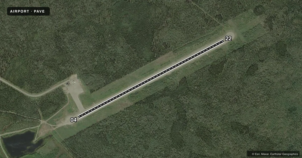
Runways & pattern
Full pagePattern entry · RWY 22
LEFT TRAFFICRunway end performance
| End | TORA | TODA | ASDA | LDA | VGSI | Approach lights | Obstruction |
|---|---|---|---|---|---|---|---|
| 04 | — | — | — | — | — | — | 15', road, 300' from thr, 0' R of cntrln, slope 20 |
| 22 | — | — | — | — | — | — | 45', trees, 1006' from thr, 214' R of cntrln, slope 22 |
Declared distances in feet. TORA = takeoff run available, TODA = takeoff distance, ASDA = accelerate-stop, LDA = landing distance.
Airport sketch
Runways drawn to scale from FAA survey coordinates, rendered over satellite imagery. Not for navigation.
Approaches & charts
Services on the field
Fuel grades, oxygen, maintenance, ramp storage and lighting — as declared to the FAA by the airport operator.
Fuel & services
- Fuel
- Not available
- Oxygen (bottled)
- Not available
- Oxygen (bulk)
- Not available
- Airframe repair
- Not available
- Power plant repair
- Not available
- Other services
- CARGO
Ramp & ground
- Transient storage
- Not published
- Landing fee
- No fee published
- Customs
- Not available
- Lighting schedule
- SEE RMK
- Beacon schedule
- SEE RMK
- Beacon
- White / Green (civil land)(WG)
- Wind indicator
- Lighted
- Segmented circle
- Yes
Fuel & FBOs
Cheapest 100LL and Jet A on the field and nearby. Always confirm with the FBO before taxi.
Airport notes
Surface conditions, obstructions, local procedures, lighting outages and other notes published with each FAA cycle.
General notes
- PPR BEFORE LNDG PHONE 907-849-8165.
- MAINT IN WINTER VARIABLE.
- CONSTRUCTION EQUIPMENT & PERSONS OPERATING ON & INVOF OF RY.
- RY 04 ROAD TRANSITS RY APRX 300 FT FM THLD.
- TAXIWAY LGTS OTS INDELFY.
- ROTG BCN OTS INDEFLY.
Lighting notes
- ACTVT ROTG BCN - CTAF.
- ACTVT MIRL RY 04/22 - CTAF.
Other notes
- 04/22RY 04/22 SFC SLIPPERY WHEN WET, SFC UNEVEN & SPARSELY GRVLD.
VFR map & nearby airports
VFR sectional. Tap any ICAO chip to open that airport.
Key facts · PAVE
Answer card- ICAO
- PAVE
- Name
- VENETIE
- Location
- VENETIE, ALASKA
- Elevation
- 574.1 ft MSL
- Traffic pattern altitude
- 1,574.1 ft MSL (1,000 AGL)
- Control tower
- Non-towered (use CTAF)
- Total runways
- 1
- Longest runway
- 04/22 · 4,000 ft
- Published ILS approaches
- 0
- Published frequencies
- 1
- Magnetic variation
- 18°
- Current flight rules
- VFR
- Current wind
- 260° at 3 kt
- Favored runway now
- RWY 22
Venetie Airport sits in Venetie, Alaska. Field elevation is 574.1 ft MSL. The airport has one runway. Runway 04/22 is 4,000 ft long and surfaced with gravel. There is no control tower. CTAF is 122.9. No ILS approaches are published.
Pattern altitude is not published. Use the standard 1,000 ft AGL pattern for light piston traffic unless the current Chart Supplement says otherwise. The field sits in a remote part of Alaska. Expect winter maintenance to vary. The runway remarks also matter. Runway 04 is crossed by a road about 300 ft from the threshold. The surface is reported as slippery when wet. It is uneven and sparsely graveled. Construction equipment and people have been operating on and near the runway.
Lighting is CTAF activated for the medium intensity runway lights. The rotating beacon is also listed as CTAF activated. The published remarks also say the beacon is out of service indefinitely. Taxiway lights are out of service indefinitely. Prior permission is required before landing. Call 907-849-8165 before you go. There are no on-field FBOs listed. Verify fuel and ground handling with the airport operator or by phone before arrival.