METAR & TAF PAWB
PAWB does not publish a METAR.
Showing the nearest reporting station: PFYU (FORT YUKON) · 53.3 NM away. Conditions at PAWB may differ.
METAR · PFYU
Observed 21:56Z
PFYU 272156Z 02005KT 10SM CLR 23/14 A2973
- Wind
- 020° @ 5 kt
- Visibility
- 10 SM
- Temp / Dew
- 23°C / 14°C
- Altimeter
- 29.73 inHg
- Clouds
- CLR
- Density alt
- 1,648 ft
- Ceiling
- Unlimited
- Rules
- VFR
Airport info & contacts
Manager on record, flight service, ARTCC, attendance schedule and pattern altitude — published by the FAA and refreshed every 28 days.
Location
- From city
- 0 NM N
- VFR sectional
- FAIRBANKS
- ARTCC
- ZAN · ANCHORAGE
- NOTAM facility
- FAI (NOTAM-D)
Airport manager
- Name
- JASON LUDINGTON
- Phone
- (907) 451-5280
- Address
- 2301 PEGER RD, FAIRBANKS AK 99709
Flight service · Hours
- FSS FAI
- FAIRBANKS907-474-07881-866-248-6516
- Attendance
- Unattended
Frequencies
Tap any row to copy the frequency to your clipboard.
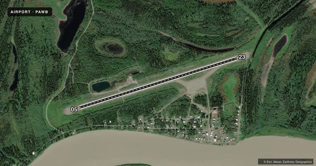
Runways & pattern
Full pagePattern entry · RWY 05
LEFT TRAFFICRunway end performance
| End | TORA | TODA | ASDA | LDA | VGSI | Approach lights | Obstruction |
|---|---|---|---|---|---|---|---|
| 05 | — | — | — | — | — | — | 25', trees, 0' from thr, 225' R of cntrln, slope 0 |
| 23 | — | — | — | — | — | — | 10', trees, 0' from thr, 249' R of cntrln, slope 0 |
Declared distances in feet. TORA = takeoff run available, TODA = takeoff distance, ASDA = accelerate-stop, LDA = landing distance.
Airport sketch
Runways drawn to scale from FAA survey coordinates, rendered over satellite imagery. Not for navigation.
Approaches & charts
Services on the field
Fuel grades, oxygen, maintenance, ramp storage and lighting — as declared to the FAA by the airport operator.
Fuel & services
- Fuel
- Not available
- Oxygen (bottled)
- Not available
- Oxygen (bulk)
- Not available
- Airframe repair
- Not available
- Power plant repair
- Not available
Ramp & ground
- Transient storage
- Not published
- Landing fee
- No fee published
- Customs
- Not available
- Lighting schedule
- SEE RMK
- Beacon schedule
- SEE RMK
- Beacon
- White / Green (civil land)(WG)
- Wind indicator
- Yes
- Segmented circle
- Yes
Fuel & FBOs
Cheapest 100LL and Jet A on the field and nearby. Always confirm with the FBO before taxi.
Airport notes
Surface conditions, obstructions, local procedures, lighting outages and other notes published with each FAA cycle.
General notes
- RY COND NOT MONITORED; RECOMMEND VISUAL INSPECTION PRIOR TO LANDING.
- SNOW REMOVAL OPERATIONS DURING WINTER--MONITOR CTAF.
- ACTIVE ROAD TRANSITS RY 1000 FT FR RY 05 THLD.
- WX CAMERA AVBL ON INTERNET AT HTTPS://WEATHERCAMS.FAA.GOV
Lighting notes
- ACTVT ROTG BCN - CTAF.
- ACTVT MIRL RY 05/23 - CTAF.
VFR map & nearby airports
VFR sectional. Tap any ICAO chip to open that airport.
Key facts · PAWB
Answer card- ICAO
- PAWB
- Name
- BEAVER
- Location
- BEAVER, ALASKA
- Elevation
- 364.7 ft MSL
- Traffic pattern altitude
- 1,364.7 ft MSL (1,000 AGL)
- Control tower
- Non-towered (use CTAF)
- Total runways
- 1
- Longest runway
- 05/23 · 3,934 ft
- Published ILS approaches
- 0
- Published frequencies
- 1
- Magnetic variation
- 16°
- Current flight rules
- VFR
- Current wind
- 020° at 5 kt
- Favored runway now
- RWY 05
Beaver Airport (PAWB) sits in Beaver, Alaska. The field elevation is 364.7 ft MSL. It has one runway, 05/23, which is 3,934 ft long and surfaced gravel-dirt. The airport is not towered. CTAF is 122.9.
No ILS approaches are published here. The pattern altitude is not published, so plan on the standard 1,000 ft AGL unless the current FAA Chart Supplement says otherwise. That puts the traffic pattern at about 1,365 ft MSL based on the field elevation, but verify the current published pattern before you go. Winter operations matter here. Snow removal occurs during the winter. Runway condition is not monitored, so a visual inspection before landing is a good idea. An active road crosses the runway 1,000 ft from the 05 threshold. Medium intensity runway lights on 05/23 are activated by CTAF. The rotating beacon is also CTAF-activated. No on-field FBOs are listed, so contact the airport operator directly or call the field on CTAF for current services. For current weather, there is a FAA weather camera available online. Pilots should also check the current Chart Supplement for any local notes before arrival.