METAR & TAF PALR
PALR does not publish a METAR.
Showing the nearest reporting station: PACX (COLDFOOT) · 42.5 NM away. Conditions at PALR may differ.
METAR · PACX
Observed 20:56Z
PACX 272056Z AUTO 12006G16KT 10SM CLR 23/09 A2976
- Wind
- 120° @ 6G16 kt
- Visibility
- 10 SM
- Temp / Dew
- 23°C / 9°C
- Altimeter
- 29.76 inHg
- Clouds
- CLR
- Density alt
- 3,539 ft
- Ceiling
- Unlimited
- Rules
- VFR
Airport info & contacts
Manager on record, flight service, ARTCC, attendance schedule and pattern altitude — published by the FAA and refreshed every 28 days.
Location
- From city
- 0 NM N
- VFR sectional
- FAIRBANKS
- ARTCC
- ZAN · ANCHORAGE
- NOTAM facility
- WCR (NOTAM-D)
Airport manager
- Name
- JEFF RUSSELL
- Phone
- 907-452-2207
- Address
- 2301 PEGER RD, FAIRBANKS AK 99709
Flight service · Hours
- FSS FAI
- FAIRBANKS907-474-07881-866-248-6516
- Attendance
- Unattended
Frequencies
Tap any row to copy the frequency to your clipboard.
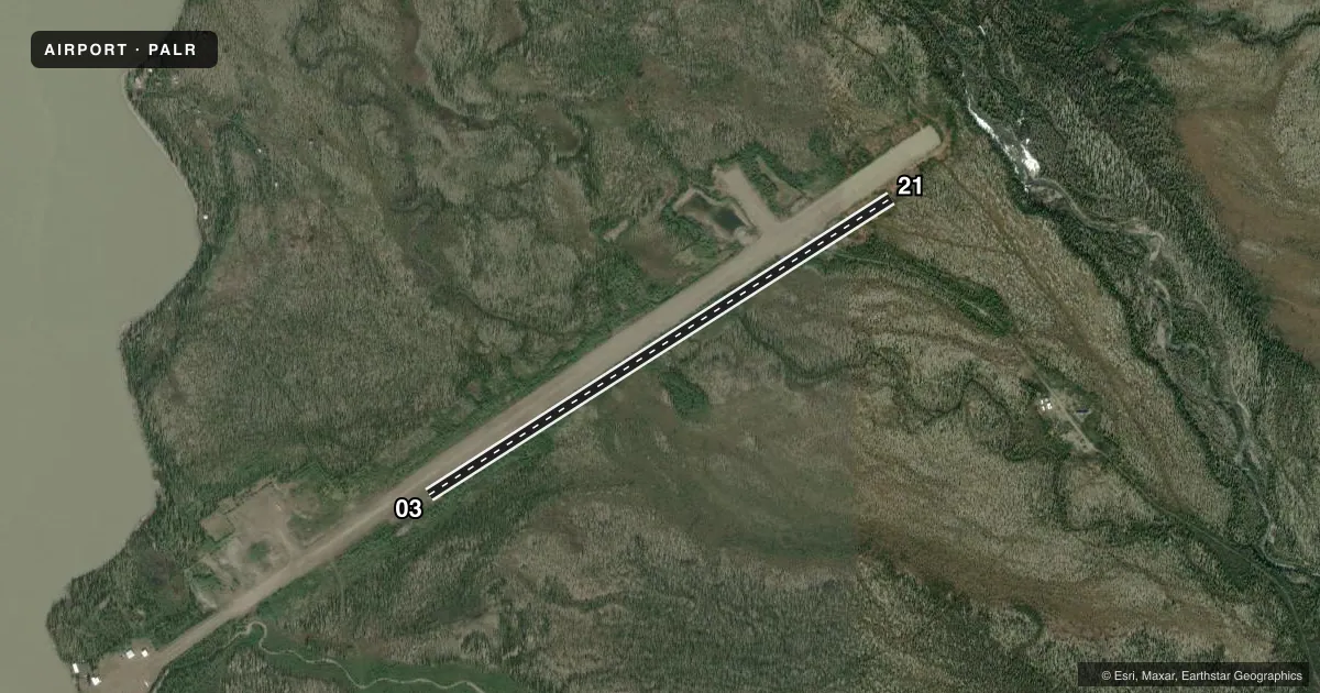
Runways & pattern
Full pagePattern entry · RWY 03
LEFT TRAFFICRunway end performance
| End | TORA | TODA | ASDA | LDA | VGSI | Approach lights | Obstruction |
|---|---|---|---|---|---|---|---|
| 03 | — | — | — | — | — | — | 8', brush, 0' from thr, 75' R of cntrln, slope 0 |
| 21 | — | — | — | — | — | — | 5', brush, 0' from thr, 60' R of cntrln, slope 0 |
Declared distances in feet. TORA = takeoff run available, TODA = takeoff distance, ASDA = accelerate-stop, LDA = landing distance.
Airport sketch
Runways drawn to scale from FAA survey coordinates, rendered over satellite imagery. Not for navigation.
Approaches & charts
Services on the field
Fuel grades, oxygen, maintenance, ramp storage and lighting — as declared to the FAA by the airport operator.
Fuel & services
- Fuel
- Not available
Ramp & ground
- Transient storage
- Tie-down
- Wind indicator
- Yes
- Segmented circle
- Yes
Fuel & FBOs
Cheapest 100LL and Jet A on the field and nearby. Always confirm with the FBO before taxi.
Airport notes
Surface conditions, obstructions, local procedures, lighting outages and other notes published with each FAA cycle.
General notes
- UNATTENDED. NO WINTER MAINT, SKI EQUIPPED AIRCRAFT ONLY. RWY NOT MAINTAINED AND CONDITION NOT MONITORED, RECOMMEND VISUAL INSPECTION PRIOR TO LANDING
Runway surface & condition
- 03/21SLOPES DOWN HILL 4% FROM N TO S.
Approach & departure obstructions
- 03RYS 04 & 22 NSTD MKGS; THLDS MKD WITH REFLECTIVE BOARDS, NO EDGE MKRS.
VFR map & nearby airports
VFR sectional. Tap any ICAO chip to open that airport.
Key facts · PALR
Answer card- ICAO
- PALR
- Name
- CHANDALAR LAKE
- Location
- CHANDALAR LAKE, ALASKA
- Elevation
- 1,920 ft MSL
- Traffic pattern altitude
- 2,920 ft MSL (1,000 AGL)
- Control tower
- Non-towered (use CTAF)
- Total runways
- 1
- Longest runway
- 03/21 · 3,000 ft
- Published ILS approaches
- 0
- Published frequencies
- 1
- Magnetic variation
- 22°
- Current flight rules
- VFR
- Current wind
- 120° at 6 kt
- Favored runway now
- RWY 03
Chandalar Lake Airport (PALR) is at Chandalar Lake, Alaska. The field elevation is 1,920 ft MSL. It has one runway. Runway 03/21 is 3,000 ft long with a gravel-dirt surface. The airport is unattended. There is no control tower. CTAF is 122.9.
No ILS approaches are published here. The pattern altitude is not published, so verify the current Chart Supplement before you go. The airport is high enough that density altitude can matter on warm days. The runway also slopes downhill 4 percent from north to south. That can change your takeoff and landing picture. The runway is not maintained and its condition is not monitored. A visual inspection before landing is recommended.
This is a ski-aircraft field in winter. Only ski-equipped aircraft are permitted then. There is no winter maintenance. Runway 04 and 22 have nonstandard markings. Thresholds are marked with reflective boards. There are no edge markers. There are no on-field FBOs listed. Check the airport operator or the current FAA Chart Supplement before arrival if you need current field condition details or local operating notes.